Difference between revisions of "2012-03-17 36 -88"
From Geohashing
imported>Team Tismon (→Participants) |
imported>Team Tismon (→Participants) |
||
| Line 25: | Line 25: | ||
== Participants == | == Participants == | ||
| − | *[[Team Tismon]] | + | *[[User:Team Tismon]] |
== Plans == | == Plans == | ||
Revision as of 16:00, 20 March 2012
| Sat 17 Mar 2012 in 36,-88: 36.9936191, -88.0928919 geohashing.info google osm bing/os kml crox |
Location
This was in the north-east corner of the Land Between the Lakes surrounded by lots of thorns.
- Latitude Longitude
- N 36 59.617 W 88 05.574
Participants
Plans
We were intending on this being a pretty quick run, but the downed trees and thorns made this much more interesting than expected.
Expedition
In the end, we got it and placed a geocache (future link) very nearby. We spent the rest of the day getting some of the more difficult caches in that area. Even ran across some devil's walking sticks among the thorns.
There should be a Luck of the Irish ribbon!
Photos
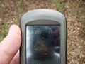
Proof

The team...some trying to hide behind the flyer
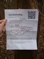
The flyer
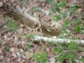
Devil's walking stick
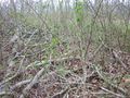
Lots of thorns
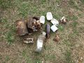
Trash


Achievements
Team Tismon earned the Land geohash achievement
|
Team Tismon earned the GeoTrash Geohash Achievement
|