Difference between revisions of "2012-03-18 -37 145"
imported>Kozz ([live picture] Hashpoint location) |
m (More specific location) |
||
| (30 intermediate revisions by 6 users not shown) | |||
| Line 1: | Line 1: | ||
| − | |||
| − | |||
| − | |||
| − | |||
| − | |||
| − | |||
| − | |||
| − | |||
| − | |||
| − | |||
{{meetup graticule | {{meetup graticule | ||
| lat=-37 | | lat=-37 | ||
| Line 14: | Line 4: | ||
| date=2012-03-18 | | date=2012-03-18 | ||
}} | }} | ||
| − | |||
| − | |||
__NOTOC__ | __NOTOC__ | ||
== Location == | == Location == | ||
| − | |||
== Participants == | == Participants == | ||
| − | + | *[[User:Kozz|kozz]], dog, wife and child | |
| + | *[[User:MykaDragonBlue|myka]] and Ez with [[User:MykaDragonBlue/Hashscot|possibly Fergus]] and polyester Bear | ||
| + | *[[User:Felix Dance|Felix Dance]] and [[User:Stevage|Stevage]] | ||
== Plans == | == Plans == | ||
| − | + | Kozz took his family for a walk at the hashpoint. | |
| + | Myka and Ez will be heading out after lunch, to have a look around | ||
| + | |||
| + | == Kozz == | ||
| + | [[user:kozz|Kozz]]: I spotted this last night and not seeing a grat page decided to do an in & out mission to Shepherd's Bush. The dog was an automatic +1, especially given there's an offlead area like 200m from the hashpoint, and I am familiar with the area as I frequently run up and down the EastLink Trail which is a few hundred metres away. Surprisingly, the wife and child decided to come along which, in combo with the dog, negated the possibility of a Run, Walk or Cycle hash. | ||
| + | |||
| + | We navigated in from Norton's Park and found the hashpoint - like Felix below, it seemed to think said hashpoint was on a well-formed trail in the middle of Shepherd's Bush, but the phone was jumping about 20 metres on each resync and wouldn't settle down, so I figure within the 10metre boundary would've been close. The phone initially said the hashpoint was right in the middle of the river - judging from Felix & Stevage's photos it was probably 5 metres up a bank off the trail. Anyway. Solid hash! | ||
| + | |||
| + | The whole area is awesome, there are bike paths (the Eastlink & Jells Park trail) nearby so very well habited. Glad to see there was a good turnout especially on a sports-packed day (Formula 1 + Rebels game) | ||
| + | |||
| + | Not sure when Myka & Ez got there but from the looks of the photos it wasn't much later than the Kozzezes. Next time, mate. | ||
| + | |||
| + | ==Myka And Ez== | ||
| + | We Arrives at Nortons park by car at around 1:45, apparently parking in pretty much the same spot as Kozz. we investigated the swamp with their very loud frogs, and enjoyed the park as we wandered down in the direction of the hash. | ||
| + | |||
| + | The quiet of the parks was quite amazing. If it was not for the quiet rumble of eastlink in the distance, it would have been hard to tell there was Melbourne around. It's somewhere myka shall have to go to again he thinks. It was a worthwhile trip just for that, if nothing else. | ||
| − | + | We found the hashpoint, and my GPS indicated it was just off the path, uphill from the creek... exactly where Kozz had taken the photo. after finding the hash, I decided to attempt to re-create the photo. I think it worked rather ok. | |
| − | |||
| + | We wandered back a different way and ended our rather enjoyable walk back at the parking area, after picking up a bag of clothes which had apparently been bagged up in preperation for recycling, but then dumped instead. Myka was just going to take them to a bin, but then Ez decided to take them, wash them, and add them to some she is going to donate to the salvos. | ||
| + | |||
| + | We arrived back at the car at about 2:30, having spent about 45 minutes in the area. | ||
| + | |||
| + | == [[User:Felix Dance|Felix Dance]] & [[User:Stevage|Stevage]] == | ||
| + | Apparently there were two expeditions! Oops. [[User:Felix Dance|Felix Dance]] and [[User:Stevage|Stevage]] cycled there, arriving around 4:45pm. Taking a navigationally suboptimal route, we found ourselves on the wrong side of the creek. Probably the most efficient thing to do would be to ride to the nearest bridge and back. Instead, we availed ourselves of a fallen log suspended over the creek. | ||
| + | |||
| + | Foolishly I couldn't find my GPS and had to rely on my phone. It said the point was basically right on the path. Felix's GPS didn't really settle down and seemed to be pointing into the bushes. We shrugged, took our photos, and headed back over the log of doom. | ||
| − | |||
== Tracklog == | == Tracklog == | ||
| − | + | *[http://app.strava.com/rides/5359553 Expedition #2] | |
| + | *[http://maps.cloudmade.com/?lat=-37.853712&lng=145.036354&zoom=12&directions=-37.79302,144.94222000000002,-37.80100196273655,144.9565315246582,-37.81107234249728,144.96468544006348,-37.853508811678125,144.98223781585693,-37.8616746913589,144.97507095336914,-37.867637583794796,144.9789547920227,-37.86841678977353,144.99034881591797,-37.81876830615201,144.99953269958496,-37.81080110447367,145.0261402130127,-37.81107234249728,145.0444221496582,-37.81327611450224,145.04412174224854,-37.822327841750955,145.0651502609253,-37.824938058756246,145.0696563720703,-37.83053107003993,145.0715446472168,-37.83293762928775,145.07184505462646,-37.83425950871272,145.08077144622803,-37.83608976419996,145.09197235107422,-37.84300365290346,145.0883674621582,-37.84476591303736,145.10437488555908,-37.84967968521245,145.10939598083496,-37.85361046719292,145.11488914489746,-37.85699890414293,145.13184070587158,-37.8648255980463,145.1909351348877,-37.88127249872226,145.1903772354126,-37.881450328765084,145.19105315208435&travel=bicycle&styleId=1&geocoding=house:124;+street:Melrose;+city:North+Melbourne&active_page=0&results_number=10&search_bbox=-38.38688056984748+144.06784057617188,-37.460688409207044+146.36123657226562&bbox=-38.38688056984748+144.06784057617188,-37.460688409207044+146.36123657226562&opened_tab=1 Felix's route] from home - including return: 75kms. | ||
== Photos == | == Photos == | ||
| − | + | ===Kozz=== | |
| − | |||
| − | |||
<gallery perrow="5"> | <gallery perrow="5"> | ||
| + | |||
| + | Image:2012-03-18_-37_145_21-16-24-486.jpg | Kozz's dog | ||
| + | |||
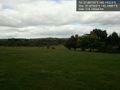
| + | Image:2012-03-18_-37_145_21-15-32-110.jpg | Norton Park | ||
| + | |||
| + | Image:2012-03-18_-37_145_21-17-29-607.jpg | Check Myka's photo below... | ||
| + | |||
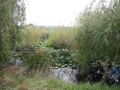
| + | Image:2012-03-18_-37_145_11-24-39-138.jpg | Ponds nearby | ||
| + | |||
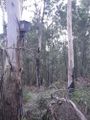
| + | Image:2012-03-18_-37_145_10-41-24-529.jpg | Hashpoint location | ||
Image:2012-03-18_-37_145_10-06-27-417.jpg | Reached! | Image:2012-03-18_-37_145_10-06-27-417.jpg | Reached! | ||
| − | |||
</gallery> | </gallery> | ||
| − | == | + | ===Myka & Ez=== |
| − | + | <gallery perrow="5"> | |
| − | + | ||
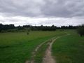
| + | Image:2012-03-18_-37_145_12-51-31-173.jpg | Arrived at Norton park. The hash is down that way [http://www.openstreetmap.org/?lat=-37.87920495&lon=145.19881320&zoom=16&layers=B000FTF @-37.8792,145.1988] | ||
| + | |||
| + | Image:2012-04-18_-37_145_mdb000.jpg | there were many frogs in the ponds. | ||
| + | Image:2012-04-18_-37_145_mdb001.jpg | out of norton park into ... shepards bush? | ||
| + | Image:2012-04-18_-37_145_mdb002.jpg | there was pigeons, they were not keen on pie | ||
| + | Image:2012-04-18_-37_145_mdb003.jpg | down we go towards the creek | ||
| + | |||
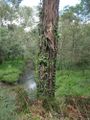
| + | Image:2012-03-18_-37_145_13-19-41-030.jpg | Recreating kozz' hash photo [http://www.openstreetmap.org/?lat=-37.88200000&lon=145.19300000&zoom=16&layers=B000FTF @-37.8820,145.1930] | ||
| + | |||
| + | Image:2012-04-18_-37_145_mdb004.jpg | hashpointnesses! | ||
| + | Image:2012-04-18_-37_145_mdb005.jpg | there were bat-houses (or similar) and markers which normally indicate paths, but just indicated scrub | ||
| + | Image:2012-04-18_-37_145_mdb006.jpg | interesting trees, and greenery by the path. pity the creek was a bit nasty | ||
| + | Image:2012-04-18_-37_145_mdb007.jpg | we found a rather chunky bag of geotrash. | ||
| + | Image:2012-04-18_-37_145_mdb008.jpg | back to Nortons Park | ||
| + | |||
| + | </gallery> | ||
| + | |||
| + | ===Felix & Stevage=== | ||
| + | <gallery perrow="5"> | ||
| + | Image:2012-03-18_-37_145_16-50-57-503.jpg | [http://www.openstreetmap.org/?lat=-37.88187808&lon=145.19318015&zoom=16&layers=B000FTF @-37.8819,145.1932] | ||
| + | |||
| + | Image:2012-03-18_-37_145_16-51-28-632.jpg | [http://www.openstreetmap.org/?lat=-37.88187366&lon=145.19317777&zoom=16&layers=B000FTF @-37.8819,145.1932] | ||
| + | |||
| + | Image:2012-03-18_-37_145_16-52-08-307.jpg | [http://www.openstreetmap.org/?lat=-37.88188964&lon=145.19319676&zoom=16&layers=B000FTF @-37.8819,145.1932] | ||
| + | |||
| + | Image:2012-03-18_-37_145_19-37-31-134.jpg | [http://www.openstreetmap.org/?lat=-37.83548850&lon=145.09160250&zoom=16&layers=B000FTF @-37.8355,145.0916] | ||
| + | |||
| + | Image:2012-03-18_-37_145_19-38-09-130.jpg | [http://www.openstreetmap.org/?lat=-37.83546550&lon=145.09160360&zoom=16&layers=B000FTF @-37.8355,145.0916] | ||
| + | Image:2012-03-18_-37_145_19-38-51-874.jpg | | ||
| − | < | + | </gallery> |
| − | |||
| − | |||
| − | + | == Achievements == | |
| − | + | {{#vardefine:ribbonwidth|800px}} | |
| − | [[ | + | {{Bicycle geohash |
| − | + | | latitude = -37 | |
| + | | longitude = 145 | ||
| + | | date = 2012-03-18 | ||
| + | | name = [[User:Felix Dance|Felix Dance]] and [[User:Stevage|Stevage]] | ||
| + | | distance = 75/45kms | ||
| + | | image = | ||
| + | }} | ||
| − | |||
[[Category:Expeditions]] | [[Category:Expeditions]] | ||
| − | |||
[[Category:Expeditions with photos]] | [[Category:Expeditions with photos]] | ||
| − | |||
| − | |||
| − | |||
| − | |||
| − | |||
[[Category:Coordinates reached]] | [[Category:Coordinates reached]] | ||
| − | + | {{location|AU|VIC|KN}} | |
| − | |||
| − | |||
| − | |||
| − | |||
| − | |||
| − | |||
| − | |||
| − | |||
| − | |||
Latest revision as of 12:13, 1 August 2020
| Sun 18 Mar 2012 in -37,145: -37.8819343, 145.1932346 geohashing.info google osm bing/os kml crox |
Location
Participants
- kozz, dog, wife and child
- myka and Ez with possibly Fergus and polyester Bear
- Felix Dance and Stevage
Plans
Kozz took his family for a walk at the hashpoint. Myka and Ez will be heading out after lunch, to have a look around
Kozz
Kozz: I spotted this last night and not seeing a grat page decided to do an in & out mission to Shepherd's Bush. The dog was an automatic +1, especially given there's an offlead area like 200m from the hashpoint, and I am familiar with the area as I frequently run up and down the EastLink Trail which is a few hundred metres away. Surprisingly, the wife and child decided to come along which, in combo with the dog, negated the possibility of a Run, Walk or Cycle hash.
We navigated in from Norton's Park and found the hashpoint - like Felix below, it seemed to think said hashpoint was on a well-formed trail in the middle of Shepherd's Bush, but the phone was jumping about 20 metres on each resync and wouldn't settle down, so I figure within the 10metre boundary would've been close. The phone initially said the hashpoint was right in the middle of the river - judging from Felix & Stevage's photos it was probably 5 metres up a bank off the trail. Anyway. Solid hash!
The whole area is awesome, there are bike paths (the Eastlink & Jells Park trail) nearby so very well habited. Glad to see there was a good turnout especially on a sports-packed day (Formula 1 + Rebels game)
Not sure when Myka & Ez got there but from the looks of the photos it wasn't much later than the Kozzezes. Next time, mate.
Myka And Ez
We Arrives at Nortons park by car at around 1:45, apparently parking in pretty much the same spot as Kozz. we investigated the swamp with their very loud frogs, and enjoyed the park as we wandered down in the direction of the hash.
The quiet of the parks was quite amazing. If it was not for the quiet rumble of eastlink in the distance, it would have been hard to tell there was Melbourne around. It's somewhere myka shall have to go to again he thinks. It was a worthwhile trip just for that, if nothing else.
We found the hashpoint, and my GPS indicated it was just off the path, uphill from the creek... exactly where Kozz had taken the photo. after finding the hash, I decided to attempt to re-create the photo. I think it worked rather ok.
We wandered back a different way and ended our rather enjoyable walk back at the parking area, after picking up a bag of clothes which had apparently been bagged up in preperation for recycling, but then dumped instead. Myka was just going to take them to a bin, but then Ez decided to take them, wash them, and add them to some she is going to donate to the salvos.
We arrived back at the car at about 2:30, having spent about 45 minutes in the area.
Felix Dance & Stevage
Apparently there were two expeditions! Oops. Felix Dance and Stevage cycled there, arriving around 4:45pm. Taking a navigationally suboptimal route, we found ourselves on the wrong side of the creek. Probably the most efficient thing to do would be to ride to the nearest bridge and back. Instead, we availed ourselves of a fallen log suspended over the creek.
Foolishly I couldn't find my GPS and had to rely on my phone. It said the point was basically right on the path. Felix's GPS didn't really settle down and seemed to be pointing into the bushes. We shrugged, took our photos, and headed back over the log of doom.
Tracklog
- Expedition #2
- Felix's route from home - including return: 75kms.
Photos
Kozz
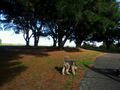
Kozz's dog
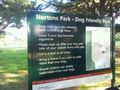
Norton Park
Check Myka's photo below...
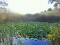
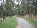
Ponds nearby
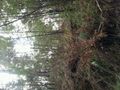
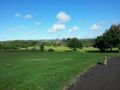
Hashpoint location
Reached!


Myka & Ez
Arrived at Norton park. The hash is down that way @-37.8792,145.1988
there were many frogs in the ponds.
out of norton park into ... shepards bush?
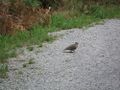
there was pigeons, they were not keen on pie
down we go towards the creek
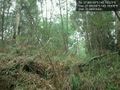
Recreating kozz' hash photo @-37.8820,145.1930

hashpointnesses!
there were bat-houses (or similar) and markers which normally indicate paths, but just indicated scrub
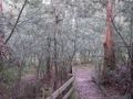
interesting trees, and greenery by the path. pity the creek was a bit nasty
we found a rather chunky bag of geotrash.
back to Nortons Park


Felix & Stevage


Achievements
Felix Dance and Stevage earned the Bicycle geohash achievement
|