Difference between revisions of "2012-03-20 -35 149"
imported>Mampfred (→1PE) |
m (More specific location) |
||
| (4 intermediate revisions by 3 users not shown) | |||
| Line 7: | Line 7: | ||
__NOTOC__ | __NOTOC__ | ||
== Location == | == Location == | ||
| − | + | A cow pasture at Carwoola, ~40km east of Canberra. | |
== Participants == | == Participants == | ||
| Line 31: | Line 31: | ||
Image:2012-03-20_-35_149-StThomas.JPG | St Thomas, Carwoola; a fine, historic church about 1.5km back up the road towards Queanbeyan and Canberra. | Image:2012-03-20_-35_149-StThomas.JPG | St Thomas, Carwoola; a fine, historic church about 1.5km back up the road towards Queanbeyan and Canberra. | ||
</gallery> | </gallery> | ||
| + | |||
| + | ==Award== | ||
| + | {{land geohash | ||
| + | | latitude = -35 | ||
| + | | longitude = 149 | ||
| + | | date = 2012-03-20 | ||
| + | | name = [[User:1PE|1PE]] | ||
| + | | image = 2012-03-20_-35_149-gate-poster.JPG | ||
| + | }} | ||
[[Category:Expeditions]] | [[Category:Expeditions]] | ||
[[Category:Expeditions with photos]] | [[Category:Expeditions with photos]] | ||
[[Category:Coordinates reached]] | [[Category:Coordinates reached]] | ||
| + | {{location|AU|NSW|QB}} | ||
Latest revision as of 12:13, 1 August 2020
| Tue 20 Mar 2012 in -35,149: -35.4478887, 149.4070098 geohashing.info google osm bing/os kml crox |
Location
A cow pasture at Carwoola, ~40km east of Canberra.
Participants
Plans
1PE realised that this was another lunch-time excursion, driving about 30km from the workplace.
1PE
1PE: This was just off the Captains Flat road at Carwoola in New South Wales, in the lovely Primrose Valley, some 40km by road east out of Canberra. I expected: great grass, lambs and cattle; I got: cattle dung in a field, and some puddles from recent rain. Google showed that site was adjacent to a gate in a farm field on the road, so access would be good. There is another gate and shed opposite as roadside markers. Tracks run from the gate into the field. And... so it was. The tracks led directly to the site that was otherwise unremarkable. I also investigated the marked square just to the north in the images and it appears to have been a fenced yard or shed site at some time, but nothing remains above ground.
I came equipped with an ActiveGeohasher.com poster (what a clever idea they are) in a plastic sleeve, and left it attached to the fence beside the gate. The farmer will hopefully see it some time before the wind shreds it, and have a laugh and a tale to tell.
Tracklog
None.
Photos
1PE
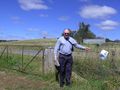
The gate, and the ActiveGeohasher.com poster. You can ALMOST smell the nearby cow dung.
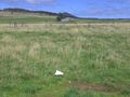
Looking south back to the gate and fence, with the shed on the other side of the road.
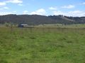
Looking north to the field's shed.
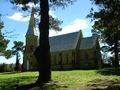
St Thomas, Carwoola; a fine, historic church about 1.5km back up the road towards Queanbeyan and Canberra.


Award
1PE earned the Land geohash achievement
|