Difference between revisions of "2012-03-23 -35 149"
From Geohashing
imported>NWoodruff (→Achievements) |
m (More specific location) |
||
| (5 intermediate revisions by 3 users not shown) | |||
| Line 1: | Line 1: | ||
| − | |||
| − | |||
| − | |||
| − | |||
| − | |||
| − | |||
| − | |||
| − | |||
| − | |||
{{meetup graticule | {{meetup graticule | ||
| lat=-35 | | lat=-35 | ||
| Line 27: | Line 18: | ||
== Expedition == | == Expedition == | ||
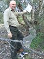
| − | + | 1PE: I had a meeting in Queanbeyan after work, so went to the hash point (beyond) before going back to the meeting. This turned out to be more interesting than the Google map suggested. There is a stile (for horsey types) at the corner of Wickerlack Road and then the track north-west into the open scrub led fairly steeply downhill. The track had been recently cut by rain and was rutted by the running water. The scrub and trees were fairly much as Google said, and the tracking to the spot was easy. I left a plastic-wrapped poster for other travellers to see and be astonished. | |
== Tracklog == | == Tracklog == | ||
| Line 45: | Line 36: | ||
| − | + | [[Category:Expeditions]] | |
| − | |||
| − | |||
| − | |||
| − | |||
| − | |||
| − | |||
| − | |||
| − | |||
| − | |||
| − | |||
| − | |||
| − | |||
| − | |||
[[Category:Expeditions with photos]] | [[Category:Expeditions with photos]] | ||
[[Category:Expedition without GPS]] | [[Category:Expedition without GPS]] | ||
[[Category:Coordinates reached]] | [[Category:Coordinates reached]] | ||
| − | + | {{location|AU|NSW|QB}} | |
| − | |||
| − | |||
| − | |||
| − | |||
| − | |||
| − | |||
| − | |||
| − | |||
Latest revision as of 12:14, 1 August 2020
| Fri 23 Mar 2012 in -35,149: -35.3886140, 149.2487151 geohashing.info google osm bing/os kml crox |
Location
Just off Wickerslack Road, Karabar (near Queanbeyan, near Canberra)
Participants
1PE and anyone else interested...
Expedition
~5.20-30pm
Expedition
1PE: I had a meeting in Queanbeyan after work, so went to the hash point (beyond) before going back to the meeting. This turned out to be more interesting than the Google map suggested. There is a stile (for horsey types) at the corner of Wickerlack Road and then the track north-west into the open scrub led fairly steeply downhill. The track had been recently cut by rain and was rutted by the running water. The scrub and trees were fairly much as Google said, and the tracking to the spot was easy. I left a plastic-wrapped poster for other travellers to see and be astonished.
Tracklog
Photos
There I am
