Difference between revisions of "2012-03-28 48 11"
imported>The T-Man m (→Plans) |
imported>FippeBot m (Location) |
||
| (5 intermediate revisions by 2 users not shown) | |||
| Line 1: | Line 1: | ||
| − | |||
| − | |||
| − | |||
| − | |||
| − | |||
| − | |||
| − | |||
| − | |||
| − | |||
{{meetup graticule | {{meetup graticule | ||
| lat=48 | | lat=48 | ||
| Line 13: | Line 4: | ||
| date=2012-03-28 | | date=2012-03-28 | ||
}} | }} | ||
| − | |||
| − | |||
__NOTOC__ | __NOTOC__ | ||
== Location == | == Location == | ||
| Line 20: | Line 9: | ||
== Participants == | == Participants == | ||
| − | [[User:DerFlob|DerFlob]] | + | [[User:DerFlob|DerFlob]]; [[User:The_T-Man|The_T-Man]] |
== Plans == | == Plans == | ||
| Line 26: | Line 15: | ||
:I'll buy myself a day-ticket tomorrow. Cycling is out of question, since I caught [[User:Scherzkeks|Scherzkeks']] cold. Probably going there after university, which ends at about 12:00 at Martinsried. From there I'll go to Karlsfeld via S-Bahn. -[[User:The T-Man|The T-Man]] 14:37, 27 March 2012 (EDT) | :I'll buy myself a day-ticket tomorrow. Cycling is out of question, since I caught [[User:Scherzkeks|Scherzkeks']] cold. Probably going there after university, which ends at about 12:00 at Martinsried. From there I'll go to Karlsfeld via S-Bahn. -[[User:The T-Man|The T-Man]] 14:37, 27 March 2012 (EDT) | ||
::Oh, and by the way: Lessingstraße AND Münchener Straße for my Monopoly project! :D -[[User:The T-Man|The T-Man]] 14:38, 27 March 2012 (EDT) | ::Oh, and by the way: Lessingstraße AND Münchener Straße for my Monopoly project! :D -[[User:The T-Man|The T-Man]] 14:38, 27 March 2012 (EDT) | ||
| + | :::Seems like I might be there at around 4 p.m., too, due to a slight change of plan -[[User:The T-Man|The T-Man]] 05:59, 28 March 2012 (EDT) | ||
== Expedition == | == Expedition == | ||
| − | |||
| − | == | + | === [[User:DerFlob|DerFlob]] === |
| − | + | ||
| + | I started my bike ride at about 2 p.m. I estimated that it will take about 90 minutes, but I wanted a bit of spare time so I wouldn't be late, because I haven't been cycling that far for a long time and maybe only a hand full of times overall. For routing I used a track calculated at OpenCycleMap.org, which I put on my new Garmin eTrex 20 that had been delivered the same morning. | ||
| + | At first I didn't follow the recommended track, because it would have routed me through München's pedestrian area, which probably would have been quite crowded. Instead I crossed the Isar river a bit to the north at the Friedensengel and got back on track thereafter. After driving through München's [http://en.wikipedia.org/wiki/Olympiapark,_Munich Olympiapark], the ride was rather unspectacular, mostly following a highway alongside towards Karlsfeld. After arriving at the hashpoint and taking some pictures, I still had some time before [[User:The_T-Man|The_T-Man]] wanted to arrive, so I headed towards the suburban train station of Karlsfeld, where I waited a few minutes for him to arrive. After heading back to the point, taking some additional pictures, we parted at the train station, from where I started my ride home. | ||
| + | This time I drove through München's center and pedestrian area, which, as expected, turned out to be a mistake, due to it being quite crowded and some evening rush hour traffic. Thus, it took me a good 2 hours to get back home, which can also be contributed to me being quite exhausted. In the end I cycled about 50km. | ||
| + | === [[User:The_T-Man|The_T-Man]] === | ||
| + | |||
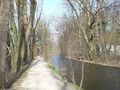
| + | On the day of this expedition I also had to go to my chemistry practical course and give some English lessons (as to whether or not my contributions on this wiki show any qualification on my side for this kind of job I leave open to you), so a lot of commuting had to be done. For the overall distance of about 110 kilometers I had to travel, a day-ticket was well worth its price. After visiting my mum for lunch, I took a train to Karlsfeld, where I was rather surprised to meet DerFlob right away, who had no difficulties spotting me while I just stared at my GPS while walking, which I tend to do far too often. Together we made it to the hashpoint, which my GPS displayed to be on a parking car some five or six meters away from where DerFlob's GPS had guided him. However, we had been at both locations, so that's alright. The way back was just as uneventful as it was before in the opposite direction, however, the beautiful weather as well as the not-so-urban environment with lots of plants and the Würmkanal river made it a rather pleasant journey. | ||
| + | |||
| + | <!--== Tracklog == | ||
| + | if your GPS device keeps a log, you may post a link here | ||
| + | maybe to follow -~~~~ | ||
| + | --> | ||
== Photos == | == Photos == | ||
| − | + | ||
| − | + | === [[User:DerFlob|DerFlob]] === | |
| − | + | ||
<gallery perrow="5"> | <gallery perrow="5"> | ||
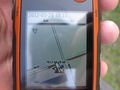
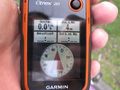
| + | Image:2012-03-28 48 11 Flob 01.jpg | Proof 1 | ||
| + | Image:2012-03-28 48 11 Flob 02.jpg | Proof 2 | ||
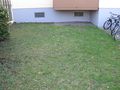
| + | Image:2012-03-28 48 11 Flob 03.jpg | Hash is on this piece of grass | ||
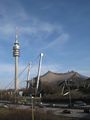
| + | Image:2012-03-28 48 11 Flob 04.jpg | Olympiaturm to the left and parts of Olympiahalle to the right | ||
</gallery> | </gallery> | ||
| − | == | + | === [[User:The_T-Man|The_T-Man]] === |
| − | |||
| − | |||
| − | |||
| − | |||
| − | |||
| − | |||
| − | |||
| − | |||
| + | <gallery perrow="5"> | ||
| + | Image:2012-03-28-TMan-01.jpg | A hybrid bus at the university. Just listening to it accelerating is awesome! | ||
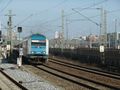
| + | Image:2012-03-28-TMan-02.jpg | The train that brought me to Karlsfeld. Missed the one 20 minutes before by 10 seconds or so. | ||
| + | Image:2012-03-28-TMan-03.jpg | En route to the hashpoint | ||
| + | Image:2012-03-28-TMan-04.jpg | The spot was right in front of this residential building | ||
| + | Image:2012-03-28-TMan-05.jpg | My GPS showed this Mercedes™ to be the hashcar of the day | ||
| + | Image:2012-03-28-TMan-06.jpg | Us hoping that nobody steals the camera while we take a picture of ourselves | ||
| + | Image:2012-03-28-TMan-07.jpg | A train towards [[2012-03-01 47 11|Gmund]] as seen on my way back | ||
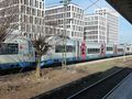
| + | Image:2012-03-28-TMan-08.jpg | Another train leaving München with the iconic Frauenkirche in the background | ||
| + | </gallery> | ||
| − | |||
[[Category:Expeditions]] | [[Category:Expeditions]] | ||
| − | + | [[Category:Expeditions with photos]] | |
| − | [[Category:Expeditions with photos]] | ||
| − | |||
| − | |||
| − | |||
| − | |||
| − | |||
[[Category:Coordinates reached]] | [[Category:Coordinates reached]] | ||
| − | + | {{location|DE|BY|DAH}} | |
| − | |||
| − | |||
| − | |||
| − | |||
| − | |||
| − | |||
| − | |||
| − | |||
| − | |||
Latest revision as of 03:13, 13 August 2019
| Wed 28 Mar 2012 in 48,11: 48.2292002, 11.4668425 geohashing.info google osm bing/os kml crox |
Location
On Lessingstraße in Karlsfeld N of München
Participants
Plans
I'm planning to go there by bike. Probably in the afternoon, between 3 and 4 p.m. But I'm open for other time suggestions. -DerFlob 11:25, 27 March 2012 (EDT)
- I'll buy myself a day-ticket tomorrow. Cycling is out of question, since I caught Scherzkeks' cold. Probably going there after university, which ends at about 12:00 at Martinsried. From there I'll go to Karlsfeld via S-Bahn. -The T-Man 14:37, 27 March 2012 (EDT)
Expedition
DerFlob
I started my bike ride at about 2 p.m. I estimated that it will take about 90 minutes, but I wanted a bit of spare time so I wouldn't be late, because I haven't been cycling that far for a long time and maybe only a hand full of times overall. For routing I used a track calculated at OpenCycleMap.org, which I put on my new Garmin eTrex 20 that had been delivered the same morning. At first I didn't follow the recommended track, because it would have routed me through München's pedestrian area, which probably would have been quite crowded. Instead I crossed the Isar river a bit to the north at the Friedensengel and got back on track thereafter. After driving through München's Olympiapark, the ride was rather unspectacular, mostly following a highway alongside towards Karlsfeld. After arriving at the hashpoint and taking some pictures, I still had some time before The_T-Man wanted to arrive, so I headed towards the suburban train station of Karlsfeld, where I waited a few minutes for him to arrive. After heading back to the point, taking some additional pictures, we parted at the train station, from where I started my ride home. This time I drove through München's center and pedestrian area, which, as expected, turned out to be a mistake, due to it being quite crowded and some evening rush hour traffic. Thus, it took me a good 2 hours to get back home, which can also be contributed to me being quite exhausted. In the end I cycled about 50km.
The_T-Man
On the day of this expedition I also had to go to my chemistry practical course and give some English lessons (as to whether or not my contributions on this wiki show any qualification on my side for this kind of job I leave open to you), so a lot of commuting had to be done. For the overall distance of about 110 kilometers I had to travel, a day-ticket was well worth its price. After visiting my mum for lunch, I took a train to Karlsfeld, where I was rather surprised to meet DerFlob right away, who had no difficulties spotting me while I just stared at my GPS while walking, which I tend to do far too often. Together we made it to the hashpoint, which my GPS displayed to be on a parking car some five or six meters away from where DerFlob's GPS had guided him. However, we had been at both locations, so that's alright. The way back was just as uneventful as it was before in the opposite direction, however, the beautiful weather as well as the not-so-urban environment with lots of plants and the Würmkanal river made it a rather pleasant journey.
Photos
DerFlob
Proof 1
Proof 2
Hash is on this piece of grass
Olympiaturm to the left and parts of Olympiahalle to the right


The_T-Man
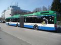
A hybrid bus at the university. Just listening to it accelerating is awesome!
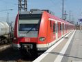
The train that brought me to Karlsfeld. Missed the one 20 minutes before by 10 seconds or so.
En route to the hashpoint
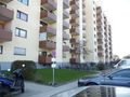
The spot was right in front of this residential building
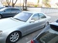
My GPS showed this Mercedes™ to be the hashcar of the day
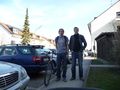
Us hoping that nobody steals the camera while we take a picture of ourselves
A train towards Gmund as seen on my way back
Another train leaving München with the iconic Frauenkirche in the background


