Difference between revisions of "2012-04-01 47 -122"
imported>Traveller (→Plans) |
imported>FippeBot m (Location) |
||
| (21 intermediate revisions by 4 users not shown) | |||
| Line 22: | Line 22: | ||
== Participants == | == Participants == | ||
<!-- who attended --> | <!-- who attended --> | ||
| − | [[User:ColinMacLeod|ColinMacLeod]] | + | [[User:ColinMacLeod|ColinMacLeod]] and son |
[[User:Traveller|Traveller]] | [[User:Traveller|Traveller]] | ||
[[User:OtherJack|OtherJack]] | [[User:OtherJack|OtherJack]] | ||
| + | |||
| + | [[User:Thomcat|Thomcat]] and dog | ||
| + | |||
| + | [[User:Michael5000|Michael5000]] and [[User:Niece4|Niece #4]] | ||
== Plans == | == Plans == | ||
| Line 39: | Line 43: | ||
We should have an alternate location in case we can't hit the primary right away. Name a spot and I'll aim for it, if there turns out to be a game. Also, my phone's completely nonfunctional now (no GPS, no camera, no phone-stuff). Should still be recognizable though... --[[User:Traveller|Traveller]] 05:23, 1 April 2012 (EDT) | We should have an alternate location in case we can't hit the primary right away. Name a spot and I'll aim for it, if there turns out to be a game. Also, my phone's completely nonfunctional now (no GPS, no camera, no phone-stuff). Should still be recognizable though... --[[User:Traveller|Traveller]] 05:23, 1 April 2012 (EDT) | ||
| + | |||
| + | How about just south of there? I mean, the point is at the very southern edge of the field. I think it'll be pretty clear. [[User:OtherJack|OtherJack]] 13:05, 1 April 2012 (EDT) | ||
| + | :Confirmed - The spot is just inside the foul line of View Ridge Baseball field #1, which is not scheduled for a game today. View Ridge #2 (diagonally across from #1) is scheduled for games at Noon and 2:00, though the fields might not be playable after yesterday's rains. I'll be under the big tree at 12:45 with a friendly dog. Cheers! --[[User:Thomcat|Thomcat]] 14:22, 1 April 2012 (EDT) | ||
== Expedition == | == Expedition == | ||
| − | + | ||
| + | [[User:OtherJack|OtherJack]] showed up around 12:55 on foot to find that [[User:Thomcat|Thomcat]] and his dog Lucy had already found the hashpoint. It was a dozen or two feet into fair territory and there was a game in progress (which [[User:Thomcat|Thomcat]] could conceivably have umpired and thus won the cubicle ribbon but did not). Jack took Thom's advice and ran onto the field between innings, getting his gps to read 0 feet for just a second before returning to foul ground, as it began to shower. [[User:Traveller|Traveller]] appeared shortly thereafter and everyone talked geohashing strategy and had a grand old time. [[User:Traveller|Traveller]]'s zeal for the squishy-consuming aspect of the sport is impressive. Eventually (1:10 or so) [[User:ColinMacLeod|ColinMacLeod]] strolled over from the east with his drag-along baby son and achieved his first hash. In a gesture of approval, the rain stopped. [[User:OtherJack|OtherJack]] had to leave five minutes later, so someone else should take over from here / modify the above... | ||
| + | |||
| + | ===Michael5000/Niece#4=== | ||
| + | |||
| + | Heading south down I-5 from Bellingham to Portland, me and Niece #4 got off the freeway and drove through pleasant residential neighborhoods to the park. We reached the hashpoint at about 1:30 p.m., which must have been within minutes of the local geohashers' convention! We left a note to mark the site in case anyone showed up behind us. Then we left in search of warm food. | ||
== Tracklog == | == Tracklog == | ||
| Line 51: | Line 63: | ||
--> | --> | ||
<gallery perrow="5"> | <gallery perrow="5"> | ||
| + | File:2012-04-01 IMG 3051.JPG | Thomcat and Traveller with Lucy | ||
| + | File:2012-04-01 IMG 3056.JPG | MacLeod does the hashdance | ||
| + | File:2012-04-01 IMG 3057.JPG | The group, minus the photographer OtherJack | ||
| + | File:2012-04-01 IMG 3052.JPG | Baseball! They didn't seem to mind | ||
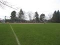
| + | File:2012-04-01 IMG 3054.JPG | View Ridge Park was nice | ||
| + | File:2012-04-01 47 -122 Michael5000.JPG|Michael5000 and Niece #4 at the hashpoint. | ||
</gallery> | </gallery> | ||
| Line 56: | Line 74: | ||
{{#vardefine:ribbonwidth|800px}} | {{#vardefine:ribbonwidth|800px}} | ||
<!-- Add any achievement ribbons you earned below, or remove this section --> | <!-- Add any achievement ribbons you earned below, or remove this section --> | ||
| + | {{Meet-up | ||
| + | |||
| + | | latitude = 47 | ||
| + | | longitude = -122 | ||
| + | | date = 2012-04-01 | ||
| + | | name = [[User:ColinMacLeod|ColinMacLeod]] and son, [[User:Traveller|Traveller]], [[User:OtherJack|OtherJack]], and [[User:Thomcat|Thomcat]] | ||
| + | | other = each other (well, mostly) | ||
| + | | image = 2012-04-01 IMG 3057.JPG | ||
| + | |||
| + | }} | ||
| + | |||
| + | {{Walk geohash | ||
| + | |||
| + | | latitude = 47 | ||
| + | | longitude = -122 | ||
| + | | date = 2012-04-01 | ||
| + | | name = [[User:ColinMacLeod|ColinMacLeod]] and [[User:OtherJack|OtherJack]] | ||
| + | }} | ||
| − | + | {{land geohash | |
| − | + | | latitude = 47 | |
| − | [[ | + | | longitude = -122 |
| + | | date = 2012-04-01 | ||
| + | | name = [[User:ColinMacLeod|ColinMacLeod]] and son | ||
| + | }} | ||
| − | + | {{Tron | |
| − | + | | latitude = 47 | |
| − | + | | longitude = -122 | |
| − | [[ | + | | date = 2012-04-01 |
| + | | tracklog = http://bit.ly/HJqsqj | ||
| + | | possessive = their | ||
| + | | name = [[User:ColinMacLeod|ColinMacLeod]] and son | ||
| + | }} | ||
| + | |||
| + | {{gratuitous ribbon | color = brown | icon = Dog.png | latitude = 47 | longitude = -122 | date = 2012-04-01 | achievement = Hashdog Ribbon | description = petting Lucy the dog at the | name = [[User:OtherJack|OtherJack]], [[User:ColinMacLeod|ColinMacLeod]] (and others??) }} | ||
| + | |||
| + | {{Geotrash | ||
| + | | latitude = 47 | ||
| + | | longitude = -122 | ||
| + | | date = 2012-04-01 | ||
| + | | name = [[User:ColinMacLeod|ColinMacLeod]] | ||
| + | }} | ||
| + | |||
| + | |||
| + | {{drag-along | ||
| + | | latitude = 47 | ||
| + | | longitude = -122 | ||
| + | | date = 2012-04-01 | ||
| + | | partner = Niece #4 | ||
| + | | name = Michael5000 | ||
| + | | 2012-04-01 47 -122 Michael5000.JPG | ||
| + | }} | ||
| + | |||
| + | |||
| + | == Fun facts == | ||
| + | *[[User:ColinMacLeod|ColinMacLeod]]'s name is not, in fact, Colin MacLeod. | ||
| + | *[[User:Thomcat|Thomcat]] is the Paul Erdős of geohashing, apparently. | ||
| + | |||
| + | *[[User:Michael5000|Michael5000]] has now dragged 75% of his nieces to hashpoints. | ||
| + | *It was also his northernmost Expedition. Six days later, though, he would get a full graticule further north, and drag along the last of the nieces. | ||
| − | |||
[[Category:Expeditions]] | [[Category:Expeditions]] | ||
| − | |||
[[Category:Expeditions with photos]] | [[Category:Expeditions with photos]] | ||
| − | |||
| − | |||
| − | |||
| − | |||
| − | |||
[[Category:Coordinates reached]] | [[Category:Coordinates reached]] | ||
| − | + | [[Category:Expeditions with dogs]] | |
| − | + | {{location|US|WA|KN}} | |
| − | |||
| − | [[Category: | ||
| − | |||
| − | |||
| − | |||
| − | |||
| − | |||
| − | |||
Latest revision as of 03:17, 13 August 2019
| Sun 1 Apr 2012 in 47,-122: 47.6803372, -122.2810392 geohashing.info google osm bing/os kml crox |
Location
View Ridge Park, along the right field line of a softball field.
Participants
ColinMacLeod and son
Thomcat and dog
Michael5000 and Niece #4
Plans
Weather permitting, I'd like to go in the early afternoon between 1pm and 2pm. -- ColinMacLeod
I'll try to make it as well (even if it's not a Saturday meet). As long as it's afternoon and not morning, I can get there. Although it occurs to me that, being right on the sidelines of a soccer field on a Sunday, right next to a school, there might be a game scheduled for the park... It could be worth calling Parks & Recreation and seeing if anyone's reserved the field? That might influence our scheduling, push it earlier or later. http://www.seattle.gov/parks/park_detail.asp?id=444 If I had a phone, I would. Also, possible squishies at the Wedgewood Chevron, NE 73rd St and 35th Ave SE. -- Traveller
Man, this is like two miles from where I live! This is going to be really easy. I could make it right at 1pm but would have to leave about 1:15 to get somewhere else. Earlier is fine too, but I'm busy 2-6. Should we say 1? 12:45? I will bring something to eat and get the picnic achievement... I encourage you all to do the same! OtherJack 18:13, 30 March 2012 (EDT)
Also, I was able to get in touch with the parks and rec guy, and he said the field is booked, but that the rain is probably going to be sufficient to rain it out. So I think that's good overall. Thanks for the link Traveller! OtherJack 18:24, 30 March 2012 (EDT)
We should have an alternate location in case we can't hit the primary right away. Name a spot and I'll aim for it, if there turns out to be a game. Also, my phone's completely nonfunctional now (no GPS, no camera, no phone-stuff). Should still be recognizable though... --Traveller 05:23, 1 April 2012 (EDT)
How about just south of there? I mean, the point is at the very southern edge of the field. I think it'll be pretty clear. OtherJack 13:05, 1 April 2012 (EDT)
- Confirmed - The spot is just inside the foul line of View Ridge Baseball field #1, which is not scheduled for a game today. View Ridge #2 (diagonally across from #1) is scheduled for games at Noon and 2:00, though the fields might not be playable after yesterday's rains. I'll be under the big tree at 12:45 with a friendly dog. Cheers! --Thomcat 14:22, 1 April 2012 (EDT)
Expedition
OtherJack showed up around 12:55 on foot to find that Thomcat and his dog Lucy had already found the hashpoint. It was a dozen or two feet into fair territory and there was a game in progress (which Thomcat could conceivably have umpired and thus won the cubicle ribbon but did not). Jack took Thom's advice and ran onto the field between innings, getting his gps to read 0 feet for just a second before returning to foul ground, as it began to shower. Traveller appeared shortly thereafter and everyone talked geohashing strategy and had a grand old time. Traveller's zeal for the squishy-consuming aspect of the sport is impressive. Eventually (1:10 or so) ColinMacLeod strolled over from the east with his drag-along baby son and achieved his first hash. In a gesture of approval, the rain stopped. OtherJack had to leave five minutes later, so someone else should take over from here / modify the above...
Michael5000/Niece#4
Heading south down I-5 from Bellingham to Portland, me and Niece #4 got off the freeway and drove through pleasant residential neighborhoods to the park. We reached the hashpoint at about 1:30 p.m., which must have been within minutes of the local geohashers' convention! We left a note to mark the site in case anyone showed up behind us. Then we left in search of warm food.
Tracklog
Photos
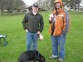
Thomcat and Traveller with Lucy
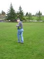
MacLeod does the hashdance
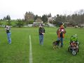
The group, minus the photographer OtherJack
Baseball! They didn't seem to mind
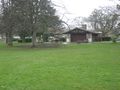
View Ridge Park was nice

Michael5000 and Niece #4 at the hashpoint.


Achievements
ColinMacLeod and son, Traveller, OtherJack, and Thomcat earned the Meet-up achievement
|
ColinMacLeod and OtherJack earned the Walk geohash Achievement
|
ColinMacLeod and son earned the Land geohash achievement
|
ColinMacLeod and son earned the Tron achievement
|
OtherJack, ColinMacLeod (and others??) earned the Hashdog Ribbon
|
ColinMacLeod earned the GeoTrash Geohash Achievement
|
Michael5000 earned the Drag-along achievement
|
Fun facts
- ColinMacLeod's name is not, in fact, Colin MacLeod.
- Thomcat is the Paul Erdős of geohashing, apparently.
- Michael5000 has now dragged 75% of his nieces to hashpoints.
- It was also his northernmost Expedition. Six days later, though, he would get a full graticule further north, and drag along the last of the nieces.