Difference between revisions of "2012-04-05 38 -90"
imported>RocketMac m (moved 2012-04-05 39 -90 to 2012-04-05 38 -90: Wrong coordinates) |
imported>FippeBot m (Location) |
||
| (3 intermediate revisions by 2 users not shown) | |||
| Line 1: | Line 1: | ||
| − | |||
| − | |||
| − | |||
| − | |||
| − | |||
| − | |||
| − | |||
| − | |||
| − | |||
| − | |||
{{meetup graticule | {{meetup graticule | ||
| − | | lat= | + | | lat=38 |
| lon=-90 | | lon=-90 | ||
| date=2012-04-05 | | date=2012-04-05 | ||
}} | }} | ||
| − | |||
| − | |||
== Location == | == Location == | ||
| − | + | A patch of grass between the freeway and a park of sorts. | |
== Participants == | == Participants == | ||
| − | + | * [[User:RocketMac|RocketMac]] - Visiting from [[43,-88|MKE]] for the week for work. | |
== Plans == | == Plans == | ||
| − | + | When I saw this morning that the hashpoint was reachable '''and''' a [[Hash_collision_achievement|hash collision]] I had to give it a try. | |
== Expedition == | == Expedition == | ||
| − | + | After my last students left, I stopped back at my hotel for dinner before heading out. I had determined a route to get there and looked up sunset for the area. My initial route took me too far North and tried to have me park on the freeway nearby instead. North of the river, I adjusted my endpoint and found a better path. One I had actually driven past on my way up. Oh well. | |
| + | |||
| + | Upon arriving at the park, I took a few pictures including the rising moon and the setting sun. There is a metal memorial shelter nearby with plantings around that I liked so I took pictures of it as well while it was still light. From there I booked down the path until I had to go off-trail to get to the hashpoint. At the hash, I took pictures as well for proof and posterity. | ||
| + | |||
| + | I had determined that there was a [http://coord.info/GC2EVR1 geocache] about 400 feet away, so I popped over there. I was trying to take a picture of the cache in its hiding spot when a red truck pulled up nearby. After a moment, it backed up and sat near where I was. I couldn't see what they were doing so I grabbed the cache and made my way to the nearby shelter for more pictures and to sign the cache log. While I was taking pictures of the shelter, the truck got bored with me and pulled away. I put the cache back and made my way back to the car to head back to the hotel. | ||
| + | |||
| + | Nice trip! | ||
== Tracklog == | == Tracklog == | ||
| − | + | My tracklog is available in [http://coldshadow.com/geohashing/2012-04-05.gpx GPX] and [http://coldshadow.com/geohashing/2012-04-05.kmz KMZ] formats. | |
== Photos == | == Photos == | ||
| − | |||
| − | |||
| − | |||
<gallery perrow="5"> | <gallery perrow="5"> | ||
| + | Image:RocketMac 2012-04-05 38 -90 08.jpg | Stupid Grin | ||
| + | Image:RocketMac 2012-04-05 38 -90 04.jpg | Highway from Hashpoint | ||
| + | Image:RocketMac 2012-04-05 38 -90 05.jpg | Highway from Hashpoint | ||
| + | Image:RocketMac 2012-04-05 38 -90 06.jpg | Highway from Hashpoint | ||
| + | Image:RocketMac 2012-04-05 38 -90 07.jpg | That's no moon... Oh wait, it is. | ||
| + | Image:RocketMac 2012-04-05 38 -90 03.jpg | RocketMac was Here | ||
| + | Image:RocketMac 2012-04-05 38 -90 01.jpg | Pretty Park | ||
| + | Image:RocketMac 2012-04-05 38 -90 02.jpg | Signage | ||
| + | Image:RocketMac 2012-04-05 38 -90 09.jpg | Geocache | ||
| + | Image:RocketMac 2012-04-05 38 -90 10.jpg | The Shelter | ||
| + | Image:RocketMac 2012-04-05 38 -90 12.jpg | Hash to Cache | ||
| + | Image:RocketMac 2012-04-05 38 -90 11.jpg | Nice Sunset | ||
</gallery> | </gallery> | ||
== Achievements == | == Achievements == | ||
{{#vardefine:ribbonwidth|800px}} | {{#vardefine:ribbonwidth|800px}} | ||
| − | + | {{land geohash | |
| + | | latitude = 38 | ||
| + | | longitude = -90 | ||
| + | | date = 2012-04-05 | ||
| + | | name = RocketMac | ||
| + | | image = | ||
| + | }} | ||
| + | {{Hash collision | ||
| + | | latitude = 38 | ||
| + | | longitude = -90 | ||
| + | | date = 2012-04-05 | ||
| + | | name = RocketMac | ||
| + | | id = GC2EVR1 | ||
| + | | link = http://coord.info/GC2EVR1 | ||
| + | | distance = 461 feet | ||
| + | | image = | ||
| + | | honor = | ||
| + | }} | ||
| − | |||
| − | |||
| − | |||
| − | |||
| − | |||
| − | |||
| − | |||
| − | |||
| − | |||
[[Category:Expeditions]] | [[Category:Expeditions]] | ||
| − | |||
[[Category:Expeditions with photos]] | [[Category:Expeditions with photos]] | ||
| − | |||
| − | |||
| − | |||
| − | |||
| − | |||
[[Category:Coordinates reached]] | [[Category:Coordinates reached]] | ||
| − | + | {{location|US|MO|SL}} | |
| − | |||
| − | |||
| − | |||
| − | |||
| − | |||
| − | |||
| − | |||
| − | |||
| − | |||
Latest revision as of 03:20, 13 August 2019
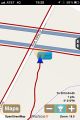
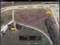
| Thu 5 Apr 2012 in 38,-90: 38.7187826, -90.5108466 geohashing.info google osm bing/os kml crox |
Location
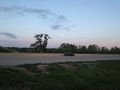
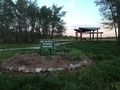
A patch of grass between the freeway and a park of sorts.
Participants
Plans
When I saw this morning that the hashpoint was reachable and a hash collision I had to give it a try.
Expedition
After my last students left, I stopped back at my hotel for dinner before heading out. I had determined a route to get there and looked up sunset for the area. My initial route took me too far North and tried to have me park on the freeway nearby instead. North of the river, I adjusted my endpoint and found a better path. One I had actually driven past on my way up. Oh well.
Upon arriving at the park, I took a few pictures including the rising moon and the setting sun. There is a metal memorial shelter nearby with plantings around that I liked so I took pictures of it as well while it was still light. From there I booked down the path until I had to go off-trail to get to the hashpoint. At the hash, I took pictures as well for proof and posterity.
I had determined that there was a geocache about 400 feet away, so I popped over there. I was trying to take a picture of the cache in its hiding spot when a red truck pulled up nearby. After a moment, it backed up and sat near where I was. I couldn't see what they were doing so I grabbed the cache and made my way to the nearby shelter for more pictures and to sign the cache log. While I was taking pictures of the shelter, the truck got bored with me and pulled away. I put the cache back and made my way back to the car to head back to the hotel.
Nice trip!
Tracklog
My tracklog is available in GPX and KMZ formats.
Photos
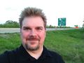
Stupid Grin
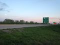
Highway from Hashpoint
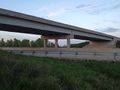
Highway from Hashpoint
Highway from Hashpoint

That's no moon... Oh wait, it is.
RocketMac was Here
Pretty Park
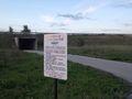
Signage
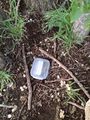
Geocache
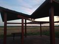
The Shelter
Hash to Cache
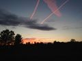
Nice Sunset


Achievements
RocketMac earned the Land geohash achievement
|
RocketMac earned the Hash collision achievement
|