Difference between revisions of "2012-04-07 47 -121"
imported>Michael5000 m (→Photos) |
m (per Renaming Proposal) |
||
| (9 intermediate revisions by 3 users not shown) | |||
| Line 33: | Line 33: | ||
I got into this expedition like people get into gambling debt, starting out with risks that seemed perfectly reasonable, then taking additional risks to justify the initial risks, and then eventually staggering around in panic and despair. Except in this version I survived the crisis and emerged a wiser man. I’ll never take foolish risks for geohashing again, or at least not for the remainder of the weekend. | I got into this expedition like people get into gambling debt, starting out with risks that seemed perfectly reasonable, then taking additional risks to justify the initial risks, and then eventually staggering around in panic and despair. Except in this version I survived the crisis and emerged a wiser man. I’ll never take foolish risks for geohashing again, or at least not for the remainder of the weekend. | ||
| − | The first bad money, after which additional bad money would be thrown, was the decision to drive 44 miles out of my way in order to take a swing at the Snoqualimie graticule. Five miles southeast of Enumclaw, Washington – an especially odd name, I’ve always thought | + | The first bad money, after which additional bad money would be thrown, was the decision to drive 44 miles out of my way in order to take a swing at the Snoqualimie graticule. Five miles southeast of Enumclaw, Washington – an especially odd name, I’ve always thought - I got to a gated forest road. I was irked to see that it was 1½ miles to the hashpoint, double what I expected. “This is going to take a whole hour!” I thought to myself. But I had already driven so far… |
| − | So I walked a half mile down a broad, well-graded road until it forked. The branch heading in the right direction was behind another gate, and badly overgrown. But by now I was within a | + | So I walked a half mile down a broad, well-graded road until it forked. The branch heading in the right direction was behind another gate, and badly overgrown. But by now I was within a mile of the hashpoint… |
The “road” now hadn’t been used in a year or two, and recent storms had blown hundreds of trees down across it. I would walk for ten seconds, and then fight my way down or around a fallen tree. This was clearly going to take a long time to pull off. But, I kept getting closer and closer! After a while, the old roadbed turned into a causeway between two shallow ponds, and then I reached a point where it had been washed away, and the gap dammed up by beavers. My Kingdom for a B-- …except, I had already worked so hard! So I scouted around until I found a line of rocks that let me hop over the stream. | The “road” now hadn’t been used in a year or two, and recent storms had blown hundreds of trees down across it. I would walk for ten seconds, and then fight my way down or around a fallen tree. This was clearly going to take a long time to pull off. But, I kept getting closer and closer! After a while, the old roadbed turned into a causeway between two shallow ponds, and then I reached a point where it had been washed away, and the gap dammed up by beavers. My Kingdom for a B-- …except, I had already worked so hard! So I scouted around until I found a line of rocks that let me hop over the stream. | ||
| Line 45: | Line 45: | ||
After that, it was just moderate bushwhacking until I got to the hashpoint – which, obnoxiously, was in the open clearing of a wide, well-maintained forest road. From somewhere, I could have just strolled up to this one. But I’m not sure where from. | After that, it was just moderate bushwhacking until I got to the hashpoint – which, obnoxiously, was in the open clearing of a wide, well-maintained forest road. From somewhere, I could have just strolled up to this one. But I’m not sure where from. | ||
| − | Epilogue: You’d think that I would have an easier time getting back. But I followed the new wide road to a dead end in one direction, and until it was heading straight away from my truck in the other, then formulated a “short cut” into some of the worst forest terrain I have ever encountered in my Northwestern life. Every fourth or fifth tree had been blown down in some crazy storm, sudden gaping holes opened out of sound looking logs, and the ground got boggier and boggier. Literally every step required bushwhacking, which I had not dressed or equipped myself | + | Epilogue: You’d think that I would have an easier time getting back. But I followed the new wide road to a dead end in one direction, and until it was heading straight away from my truck in the other, then formulated a “short cut” into some of the worst forest terrain I have ever encountered in my Northwestern life. Every fourth or fifth tree had been blown down in some crazy storm, sudden gaping holes opened out of sound looking logs, and the ground got boggier and boggier. Literally every step required bushwhacking, which I had not dressed or equipped myself for. I couldn’t go fast enough for my GPS to figure which direction I was heading in, and had to reckon my direction by the afternoon sun. Five or six times, I fell to the ground with that sickening thud of childhood. A toenail pulled partially away from a toe. And after a hour or so of this, I got to the creek. |
Well, I made it out. Seldom have I been so glad that I keep a fresh pair of clothes in my truck. I drove home, went to bed sore and with my toe throbbing with pain, and woke up stiff, sore, scratched, and bruised. And ridiculously pleased with myself. | Well, I made it out. Seldom have I been so glad that I keep a fresh pair of clothes in my truck. I drove home, went to bed sore and with my toe throbbing with pain, and woke up stiff, sore, scratched, and bruised. And ridiculously pleased with myself. | ||
| − | |||
| − | |||
| − | |||
== Photos == | == Photos == | ||
| − | |||
| − | |||
| − | |||
| − | |||
| − | |||
<gallery perrow="5"> | <gallery perrow="5"> | ||
File:2012-04-07 47 -121 Sign.JPG|A logging company sign: "Be Concerned About Quality!" | File:2012-04-07 47 -121 Sign.JPG|A logging company sign: "Be Concerned About Quality!" | ||
| + | File:2012-04-07 47 -121 Fork.JPG|The nice easy path turns off to the east. The gate leads to the Roadbed of Horrors. | ||
| + | File:2012-04-07 47 -121 Road, kind of.JPG|Endless fallen trees, every one a fence. | ||
| + | File:2012-04-07 47 -121 dam.JPG|The beaver dam. I crossed the creek on the rocks to the left. | ||
| + | File:2012-04-07 47 -121 Cliff.JPG|View from on top of the cliff. | ||
| + | File:2012-04-07 47 -121 Clearing.JPG|The hashpoint clearing. | ||
| + | File:2012-04-07 47 -121 Growl.JPG|Hashscot at Hashpoint. | ||
| + | File:2012-04-07 47 -121 Creek.JPG|Yet another obstacle. | ||
| + | File:2012-04-07 47 -121 End.JPG|Looking at my best, having made it back to the logging road. | ||
</gallery> | </gallery> | ||
| Line 67: | Line 67: | ||
<!-- Add any achievement ribbons you earned below, or remove this section --> | <!-- Add any achievement ribbons you earned below, or remove this section --> | ||
| + | {{one with nature | ||
| + | | latitude = 47 | ||
| + | | longitude = -121 | ||
| + | | date = 2012-04-07 | ||
| + | | name = [[User:Michael5000|Michael5000]] | ||
| + | }} | ||
| + | |||
| + | {{Minesweeper geohash | ||
| + | | graticule = [[Mt. St. Helens, Washington]] | ||
| + | | ranknumber = 8 | ||
| + | | n = true | ||
| + | | ne = true | ||
| + | | e = true | ||
| + | | se = true | ||
| + | | s = true | ||
| + | | sw = true | ||
| + | | w = true | ||
| + | | nw = true | ||
| + | | name = [[User:Michael5000|Michael5000]] | ||
| + | }} | ||
| − | + | {{Minesweeper geohash | |
| − | + | | graticule = [[Seattle, Washington]] | |
| − | [[ | + | | ranknumber = 6 |
| + | | n = true | ||
| + | | e = true | ||
| + | | w = true | ||
| + | | se = true | ||
| + | | sw = true | ||
| + | | s = true | ||
| + | | name = [[User:Michael5000|Michael5000]] | ||
| + | }} | ||
| − | + | * My first Expedition to the [[Snoqualmie, Washington]] graticule. | |
| − | |||
| − | [[ | ||
| − | |||
| − | |||
[[Category:Expeditions]] | [[Category:Expeditions]] | ||
| − | |||
[[Category:Expeditions with photos]] | [[Category:Expeditions with photos]] | ||
| − | |||
| − | |||
| − | |||
| − | |||
| − | |||
[[Category:Coordinates reached]] | [[Category:Coordinates reached]] | ||
| − | + | [[Category:Insane]] | |
| − | + | {{location|US|WA|KN}} | |
| − | |||
| − | [[Category: | ||
| − | |||
| − | |||
| − | |||
| − | |||
| − | |||
| − | |||
Latest revision as of 14:36, 2 April 2024
| Sat 7 Apr 2012 in 47,-121: 47.1885982, -121.8898827 geohashing.info google osm bing/os kml crox |
Location
In the woods southeast of Enumclaw, Washington.
Participants
Plans
Insufficient.
Expedition
I got into this expedition like people get into gambling debt, starting out with risks that seemed perfectly reasonable, then taking additional risks to justify the initial risks, and then eventually staggering around in panic and despair. Except in this version I survived the crisis and emerged a wiser man. I’ll never take foolish risks for geohashing again, or at least not for the remainder of the weekend.
The first bad money, after which additional bad money would be thrown, was the decision to drive 44 miles out of my way in order to take a swing at the Snoqualimie graticule. Five miles southeast of Enumclaw, Washington – an especially odd name, I’ve always thought - I got to a gated forest road. I was irked to see that it was 1½ miles to the hashpoint, double what I expected. “This is going to take a whole hour!” I thought to myself. But I had already driven so far…
So I walked a half mile down a broad, well-graded road until it forked. The branch heading in the right direction was behind another gate, and badly overgrown. But by now I was within a mile of the hashpoint…
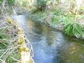
The “road” now hadn’t been used in a year or two, and recent storms had blown hundreds of trees down across it. I would walk for ten seconds, and then fight my way down or around a fallen tree. This was clearly going to take a long time to pull off. But, I kept getting closer and closer! After a while, the old roadbed turned into a causeway between two shallow ponds, and then I reached a point where it had been washed away, and the gap dammed up by beavers. My Kingdom for a B-- …except, I had already worked so hard! So I scouted around until I found a line of rocks that let me hop over the stream.
Except now, the old road was starting to curve away from the hashpoint. It wouldn’t get me any closer than .2 miles. I bushwhacked through fairly friendly forest to the .15 mark, where I was met with – a cliff. Normally, I wouldn’t have risked this cliff, especially as it wasn’t the kind of cliff one comes back down very easily. But I’d worked so hard to get to this point!
Now I am a very fit, large adult human, and not afraid of getting dirty. And I struggled mightily with this cliff. I dragged myself up five or six steps at a time from tree to tree, resting each time and breathing raggedly. And again. And again. And again. I spent a long time on this cliff face. But finally I got to a point where it was no longer as much a “cliff” as a “steep slope.” I looked at my GPS. It still said .15.
After that, it was just moderate bushwhacking until I got to the hashpoint – which, obnoxiously, was in the open clearing of a wide, well-maintained forest road. From somewhere, I could have just strolled up to this one. But I’m not sure where from.
Epilogue: You’d think that I would have an easier time getting back. But I followed the new wide road to a dead end in one direction, and until it was heading straight away from my truck in the other, then formulated a “short cut” into some of the worst forest terrain I have ever encountered in my Northwestern life. Every fourth or fifth tree had been blown down in some crazy storm, sudden gaping holes opened out of sound looking logs, and the ground got boggier and boggier. Literally every step required bushwhacking, which I had not dressed or equipped myself for. I couldn’t go fast enough for my GPS to figure which direction I was heading in, and had to reckon my direction by the afternoon sun. Five or six times, I fell to the ground with that sickening thud of childhood. A toenail pulled partially away from a toe. And after a hour or so of this, I got to the creek.
Well, I made it out. Seldom have I been so glad that I keep a fresh pair of clothes in my truck. I drove home, went to bed sore and with my toe throbbing with pain, and woke up stiff, sore, scratched, and bruised. And ridiculously pleased with myself.
Photos
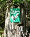
A logging company sign: "Be Concerned About Quality!"
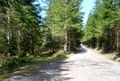
The nice easy path turns off to the east. The gate leads to the Roadbed of Horrors.
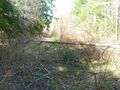
Endless fallen trees, every one a fence.
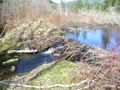
The beaver dam. I crossed the creek on the rocks to the left.
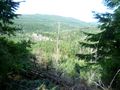
View from on top of the cliff.

The hashpoint clearing.
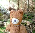
Hashscot at Hashpoint.
Yet another obstacle.

Looking at my best, having made it back to the logging road.


Achievements
Michael5000 earned the One with Nature Geohash Achievement
|
Michael5000 completed the Minesweeper Geohash achievement
|
Michael5000 achieved level 6 of the Minesweeper Geohash achievement
|
- My first Expedition to the Snoqualmie, Washington graticule.