Difference between revisions of "2012-04-18 53 -120"
imported>Dunstergirl (→Plans) |
m (per Renaming Proposal) |
||
| (15 intermediate revisions by 4 users not shown) | |||
| Line 1: | Line 1: | ||
| − | |||
| − | |||
| − | |||
| − | |||
| − | |||
{{meetup graticule | {{meetup graticule | ||
| lat=53 | | lat=53 | ||
| Line 10: | Line 5: | ||
}} | }} | ||
| − | |||
__NOTOC__ | __NOTOC__ | ||
== Location == | == Location == | ||
| Line 22: | Line 16: | ||
== Expedition == | == Expedition == | ||
| − | + | Thought about it. No-brainer, felt guilty about another highway point but we get so few that are even reachable, couldn't pass it up. Took a bath. Then got excited about taking care of my chickens and spent an hour on that and got filthy and had to change. Then finally off but had to detour to the Dunster General Store to get provisions for child. | |
| + | |||
| + | Finally off to town. Scoped the spot on my way in to McBride (yes, that is where it should be), went on and did errands (wasn't planning to go today but there is always something to do), and stopped on the way back since the spot was on that side of the highway. Wandered a bit off (see tracklog) to get my bearings, then found it. Kept expecting someone I knew (or a complete stranger) to stop and ask why I was pulled over on the side of the road in such a random spot, but nobody did. Took obligatory picture (not of me this time, those get boring fast) and then drove home. | ||
== Tracklog == | == Tracklog == | ||
| − | + | These work better for me than pictures of the stupid GPS, which never seem to turn out: [http://maps.google.ca/maps/ms?msid=209617897925873257647.0004bdfbdd5c3e513b4b9&msa=0&ll=53.271476,-120.100822&spn=0.084077,0.143681] | |
== Photos == | == Photos == | ||
| Line 32: | Line 28: | ||
--> | --> | ||
<gallery perrow="5"> | <gallery perrow="5"> | ||
| + | Image:2012-04-18 53 -120.jpg | View from near the hashpoint. Why I live here. | ||
</gallery> | </gallery> | ||
== Achievements == | == Achievements == | ||
{{#vardefine:ribbonwidth|800px}} | {{#vardefine:ribbonwidth|800px}} | ||
| − | + | {{graticule unlocked | latitude = 53 | longitude = -120 | date = 2012-04-18 | name = [[User:dunstergirl|dunstergirl]]}} | |
| + | {{Déjà vu geohash | ||
| + | | latitude = 53 | ||
| + | | longitude = -120 | ||
| + | | date = 2012-04-18 | ||
| + | | olddate = first time in 1986. Again in 1989. And thousands of times now since 1993. No proof except it's the road to town, and back. | ||
| + | |||
| + | | name = [[User:dunstergirl|dunstergirl]] | ||
| + | }} | ||
| − | |||
| − | |||
| − | |||
| − | |||
| − | |||
| − | |||
| − | |||
| − | |||
[[Category:Expeditions]] | [[Category:Expeditions]] | ||
| − | |||
[[Category:Expeditions with photos]] | [[Category:Expeditions with photos]] | ||
| − | |||
| − | |||
| − | |||
| − | |||
| − | |||
[[Category:Coordinates reached]] | [[Category:Coordinates reached]] | ||
| − | + | {{location|CA|BC|FF}} | |
| − | |||
| − | |||
| − | |||
| − | |||
| − | |||
| − | |||
| − | |||
| − | |||
| − | |||
Latest revision as of 05:40, 20 March 2024
| Wed 18 Apr 2012 in 53,-120: 53.2927153, -120.1036508 geohashing.info google osm bing/os kml crox |
Location
Near McBride, British Columbia
Participants
Plans
Right on the highway on the way to town. Drive there, scope it on the way in, do errands, come back, stop and find exact spot.
Expedition
Thought about it. No-brainer, felt guilty about another highway point but we get so few that are even reachable, couldn't pass it up. Took a bath. Then got excited about taking care of my chickens and spent an hour on that and got filthy and had to change. Then finally off but had to detour to the Dunster General Store to get provisions for child.
Finally off to town. Scoped the spot on my way in to McBride (yes, that is where it should be), went on and did errands (wasn't planning to go today but there is always something to do), and stopped on the way back since the spot was on that side of the highway. Wandered a bit off (see tracklog) to get my bearings, then found it. Kept expecting someone I knew (or a complete stranger) to stop and ask why I was pulled over on the side of the road in such a random spot, but nobody did. Took obligatory picture (not of me this time, those get boring fast) and then drove home.
Tracklog
These work better for me than pictures of the stupid GPS, which never seem to turn out: [1]
Photos
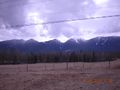
View from near the hashpoint. Why I live here.

Achievements
dunstergirl earned the Graticule Unlocked Achievement
|
dunstergirl earned the Déjà Vu Geohash Achievement
|