Difference between revisions of "2012-04-21 -37 145"
imported>Felix Dance (Added Expedition) |
m (More specific location) |
||
| (2 intermediate revisions by 2 users not shown) | |||
| Line 25: | Line 25: | ||
== Photos == | == Photos == | ||
<gallery perrow="5"> | <gallery perrow="5"> | ||
| − | + | Image:Geohash 2012 04 21 -37 145 GPS.JPG|Blurry GPS Proof | |
| + | Image:Geohash 2012 04 21 -37 145 Felix.JPG|Awkwardly close photo of Felix | ||
| + | Image:Geohash 2012 04 21 -37 145 Road.JPG|The Hash Road | ||
</gallery> | </gallery> | ||
[[Category:Expeditions]] | [[Category:Expeditions]] | ||
[[Category:Coordinates reached]] | [[Category:Coordinates reached]] | ||
| + | {{location|AU|VIC|MS}} | ||
Latest revision as of 12:15, 1 August 2020
| Sat 21 Apr 2012 in -37,145: -37.8800045, 145.1758045 geohashing.info google osm bing/os kml crox |
Location
On a residential street in Glen Waverly, Melbourne.
Who went
Expedition
Felix Dance
Checking today's hash on a Saturday at work, I found out how incredibly easy it would be - pretty much on my way home from Wonthaggi, PLUS right in the middle of a street - not even inside someone's house!
Sadly, as I left work, I realised I'd left my nobbly bike tyre at home which I needed for a mountain biking race the next day, so I had to drive back to Inverloch for that. Then I decided to take the scenic route to avoid boredom, so I went over the Strzleckis and up the Latrobe Valley.
Arriving at the hash I jumped out and took some photos on my phone (my normal camera is stuffed), before running off into a nearby park to take a much-needed piss (we guys can do these sorts of things). After this I was back in the car and on my way to tAlex' place to do a beer bottling, then off to Stevage's place to pick up him and his bike for this mountain biking thing the next day.
Here is the Google Maps route I took.
Hash reached: 3:40pm-ish
Photos
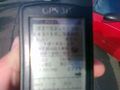
Blurry GPS Proof
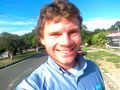
Awkwardly close photo of Felix
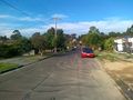
The Hash Road


