Difference between revisions of "2012-04-21 52 13"
From Geohashing
imported>Baran |
imported>Jiml m (Adjust comments) |
||
| Line 5: | Line 5: | ||
}} | }} | ||
| − | + | ||
__NOTOC__ | __NOTOC__ | ||
== Location == | == Location == | ||
| Line 21: | Line 21: | ||
== Expedition == | == Expedition == | ||
| − | Just like the plan, but could not reach geohash by motorcycle. The small sandy roads in the wood were special forest roads | + | Just like the plan, but could not reach geohash by motorcycle. The small sandy roads in the wood were special forest roads forbidden for normal vehicles. So I had to walk the rest. |
| − | |||
| − | |||
== Photos == | == Photos == | ||
<gallery perrow="5"> | <gallery perrow="5"> | ||
| − | Image: 2012-04-21_52_13-1_road_from_rail_track.jpg|Road | + | Image:2012-04-21_52_13-1_road_from_rail_track.jpg|Road coming from rail track |
| − | Image: 2012-04-21_52_13-2_parking_motorcycle.jpg|parked motorcycle | + | Image:2012-04-21_52_13-2_parking_motorcycle.jpg|parked motorcycle |
| − | Image: 2012-04-21_52_13-3_road_leading_into_forest.jpg|forest road | + | Image:2012-04-21_52_13-3_road_leading_into_forest.jpg|forest road |
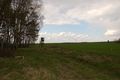
| − | Image: 2012-04-21_52_13-4_way_to_geohash.jpg|way out of the forest heading north | + | Image:2012-04-21_52_13-4_way_to_geohash.jpg|way out of the forest heading north |
| − | Image: 2012-04-21_52_13-5_last_meters.jpg|last meters | + | Image:2012-04-21_52_13-5_last_meters.jpg|last meters |
| − | Image: 2012-04-21_52_13-6_walked_into_forest.jpg|walked into forest again | + | Image:2012-04-21_52_13-6_walked_into_forest.jpg|walked into forest again |
| − | Image: 2012-04-21_52_13-7_baran_at_geohash.jpg|arrived! | + | Image:2012-04-21_52_13-7_baran_at_geohash.jpg|arrived! |
| − | Image: 2012-04-21_52_13-8_the_prove.jpg|the | + | Image:2012-04-21_52_13-8_the_prove.jpg|the proof |
</gallery> | </gallery> | ||
| Line 47: | Line 45: | ||
}} | }} | ||
| − | + | ||
[[Category:Expeditions]] | [[Category:Expeditions]] | ||
[[Category:Expeditions with photos]] | [[Category:Expeditions with photos]] | ||
[[Category:Coordinates reached]] | [[Category:Coordinates reached]] | ||
Revision as of 00:38, 22 April 2012
| Sat 21 Apr 2012 in 52,13: 52.8800045, 13.1758045 geohashing.info google osm bing/os kml crox |
Location
South of Löwenberg/Neulöwenberg.
Participants
baran by motorcycle.
Plans
Take the motorcycle, starting at Berlin Prenzlauer Berg and driving:
- federal highway 96a to Schildow
- country road L21 to Liebenwalde
- federal highway 167 to Neu Löwenberg, main station
- small road near rail track to south and then west through the forest
Expedition
Just like the plan, but could not reach geohash by motorcycle. The small sandy roads in the wood were special forest roads forbidden for normal vehicles. So I had to walk the rest.
Photos
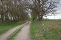
Road coming from rail track
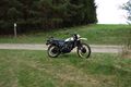
parked motorcycle
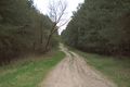
forest road
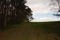
way out of the forest heading north
last meters
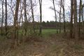
walked into forest again

arrived!
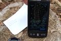
the proof


Achievements
baran earned the Land geohash achievement
|