Difference between revisions of "2012-05-04 33 -115"
imported>JesseW (add minimal report) |
imported>JesseW (longer write up, with 5 pictures!) |
||
| Line 17: | Line 17: | ||
<!-- who attended: If you link to your wiki user name in this section, your expedition will be picked up by the various statistics generated for geohashing. You may use three tildes ~ as a shortcut to automatically insert the user signature of the account you are editing with. | <!-- who attended: If you link to your wiki user name in this section, your expedition will be picked up by the various statistics generated for geohashing. You may use three tildes ~ as a shortcut to automatically insert the user signature of the account you are editing with. | ||
--> | --> | ||
| − | [[User:JesseW|JesseW]] | + | [[User:JesseW|JesseW]] (along with the other three people in the car (not pictured)) |
| + | |||
== Plans == | == Plans == | ||
<!-- what were the original plans --> | <!-- what were the original plans --> | ||
| + | On May 4th, I had an already planned trip out to Arizona (from Los Angeles). When I checked the coordinates that morning, I found that I was going to pass really close to '''three''' hashes. This was the first one. (Here are the write-ups for the [[2012-05-04_33_-114|second]] and [[2012-05-04_34_-112|third]].) | ||
== Expedition == | == Expedition == | ||
<!-- how it all turned out. your narrative goes here. --> | <!-- how it all turned out. your narrative goes here. --> | ||
| − | |||
| − | + | According to our in-car navigation system, we were supposed to get off the freeway on Chuckwalla Valley Rd., then turn on Corn Springs Rd. Soon after we turned off onto Corn Springs Rd. (which turned out to be dirt), in the middle of the desert, we found that the road was blocked by construction! Apparently they were building something for the Gas Company. At this point (33.673255, -115.236480), we decided to give up, and go on to the next one. | |
| − | |||
== Photos == | == Photos == | ||
| − | |||
| − | |||
| − | |||
<gallery perrow="5"> | <gallery perrow="5"> | ||
| + | Image:2012-05-04 33 -115 1 On the way.jpg | The in-car navigation system. | ||
| + | Image:2012-05-04 33 -115 2 Off into the desert.jpg | Heading off into the desert! | ||
| + | Image:2012-05-04 33 -115 3 Only to be stopped by construction.jpg | Only to be stopped by giant construction equipment. | ||
| + | Image:2012-05-04 33 -115 4 Silly grin.jpg | In front of which you can see my Silly Grin™. | ||
| + | Image:2012-05-04 33 -115 5 GPS.jpg | And proof (that we got close, but not there). | ||
</gallery> | </gallery> | ||
| Line 40: | Line 42: | ||
| − | |||
| − | |||
| − | |||
| − | |||
| − | |||
| − | |||
| − | |||
| − | |||
| − | |||
| − | |||
[[Category:Expeditions]] | [[Category:Expeditions]] | ||
| − | |||
[[Category:Expeditions with photos]] | [[Category:Expeditions with photos]] | ||
| − | |||
| − | |||
| − | |||
| − | + | [[Category:Coordinates not reached]] | |
| − | [[Category:Coordinates reached]] | ||
| − | |||
| − | + | [[Category:Not reached - Mother Nature]] | |
| − | + | [[Category:Not reached - No public access]] | |
| − | |||
| − | [[Category:Not reached - Mother Nature]] | ||
| − | [[Category:Not reached - No public access]] | ||
| − | |||
| − | |||
| − | |||
Revision as of 00:27, 16 May 2012
| Fri 4 May 2012 in 33,-115: 33.6134706, -115.2861907 geohashing.info google osm bing/os kml crox |
Location
Participants
JesseW (along with the other three people in the car (not pictured))
Plans
On May 4th, I had an already planned trip out to Arizona (from Los Angeles). When I checked the coordinates that morning, I found that I was going to pass really close to three hashes. This was the first one. (Here are the write-ups for the second and third.)
Expedition
According to our in-car navigation system, we were supposed to get off the freeway on Chuckwalla Valley Rd., then turn on Corn Springs Rd. Soon after we turned off onto Corn Springs Rd. (which turned out to be dirt), in the middle of the desert, we found that the road was blocked by construction! Apparently they were building something for the Gas Company. At this point (33.673255, -115.236480), we decided to give up, and go on to the next one.
Photos
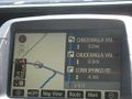
The in-car navigation system.
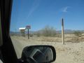
Heading off into the desert!
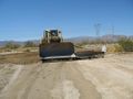
Only to be stopped by giant construction equipment.
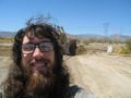
In front of which you can see my Silly Grin™.
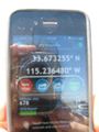
And proof (that we got close, but not there).


