Difference between revisions of "2012-05-06 52 6"
imported>Elwingelfje (→Expedition) |
imported>FippeBot m (Location) |
||
| (6 intermediate revisions by 2 users not shown) | |||
| Line 1: | Line 1: | ||
| − | |||
{{meetup graticule | {{meetup graticule | ||
| lat=52 | | lat=52 | ||
| Line 11: | Line 10: | ||
== Participants == | == Participants == | ||
| − | [[User:Elwingelfje|Elwingelfje]] | + | * [[User:Elwingelfje|Elwingelfje]] |
== Plans == | == Plans == | ||
| Line 25: | Line 24: | ||
== Photos == | == Photos == | ||
| − | + | ||
| − | + | It was getting dark so it was difficult to get a picture where it is clear that I am at the hashpoint. I took one of the google maps printout though, where you can see that the layout of the parking lot in picture one really looks a lot like the aerial photograph. Also no pictures of me actually driving through it (something about danger). | |
| − | + | ||
<gallery perrow="5"> | <gallery perrow="5"> | ||
| + | Image:2012-05-06 52 6 car.JPG | My car quite near the hashpoint | ||
| + | Image:2012-05-06 52 6 printout.JPG | See! | ||
| + | Image:2012-05-06 52 6 me.JPG | Silly grin had a day off. | ||
</gallery> | </gallery> | ||
== Achievements == | == Achievements == | ||
{{#vardefine:ribbonwidth|800px}} | {{#vardefine:ribbonwidth|800px}} | ||
| − | |||
| + | {{land geohash | ||
| + | | latitude = 52 | ||
| + | | longitude = 6 | ||
| + | | date = 2012-05-06 | ||
| + | | name = [[user:elwingelfje|elwingelfje]] | ||
| + | }} | ||
| − | + | {{Speed racer | |
| − | + | | latitude = 52 | |
| − | [[ | + | | longitude = 6 |
| + | | date = 2012-05-06 | ||
| + | | name = [[user:elwingelfje|elwingelfje]] | ||
| + | | speed = 50 km/h | ||
| + | }} | ||
| − | |||
| − | |||
[[Category:Expeditions]] | [[Category:Expeditions]] | ||
| − | |||
[[Category:Expeditions with photos]] | [[Category:Expeditions with photos]] | ||
| − | |||
[[Category:Expedition without GPS]] | [[Category:Expedition without GPS]] | ||
| − | |||
| − | |||
| − | |||
[[Category:Coordinates reached]] | [[Category:Coordinates reached]] | ||
| − | + | {{location|NL|DR}} | |
| − | |||
| − | |||
| − | |||
| − | |||
| − | |||
| − | |||
| − | |||
| − | |||
| − | |||
Latest revision as of 03:50, 13 August 2019
| Sun 6 May 2012 in 52,6: 52.9780112, 6.5630312 geohashing.info google osm bing/os kml crox |
Location
Assen
Participants
Plans
Go by car to Assen (I'm passing through anyway), leave the A28 highway, enter the parking lot and drive through at the speed limit!
Expedition
It all turned out rather well, actually.
The way there was a bit complicated as I had memorized it coming from Groningen, but I came from the other direction. I decided to exit the highway, find a spot to stop the car for a moment and turn on the navigation. At that point - oh wonder - I found out I was only one street away from the hashpoint. Amazing innate sense of direction, or just lucky? We may never know.
The hashpoint itself was in the middle of a parking lot, that apparently belonged to some ministerial building on the other side of the street. It was a lot more green and tree-ish than is visible on the satellite photo. I wish my workplace had such a nice parking lot! Another lucky point: the entrance barrier was up. Two minutes before arriving I realized I had no cash on me to pay a possible parking fee, so that was really lucky. I could drive right in. I drove through the hashpoint at the speed limit (which in the Netherlands is 50 km/h in cities) and took a few pictures. Then I quickly left, feeling a bit suspicious and out of place in the empty parking lot.
Photos
It was getting dark so it was difficult to get a picture where it is clear that I am at the hashpoint. I took one of the google maps printout though, where you can see that the layout of the parking lot in picture one really looks a lot like the aerial photograph. Also no pictures of me actually driving through it (something about danger).
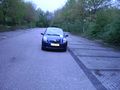
My car quite near the hashpoint
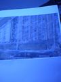
See!

Silly grin had a day off.


Achievements
elwingelfje earned the Land geohash achievement
|
