Difference between revisions of "2012-05-10 43 -87"
imported>RocketMac (Created page with "{{Subst:Expedition | lat = 43 | lon = -87 | date = 2012-05-10 }}") |
imported>FippeBot m (Location) |
||
| (12 intermediate revisions by 2 users not shown) | |||
| Line 1: | Line 1: | ||
| − | |||
| − | |||
| − | |||
| − | |||
| − | |||
{{meetup graticule | {{meetup graticule | ||
| lat=43 | | lat=43 | ||
| Line 10: | Line 5: | ||
}} | }} | ||
| − | |||
| − | |||
== Location == | == Location == | ||
| − | + | ||
| + | The corner of North and Prospect in Milwaukee, WI. | ||
== Participants == | == Participants == | ||
| − | + | ||
| − | + | *[[User:RocketMac|RocketMac]] | |
== Plans == | == Plans == | ||
| − | + | ||
| + | The Wyf has an event for work downtown tonight, so she'll be in the area. This hashpoint is only a couple of miles from [http://safe-house.com The Safe House] so I'll try to find this hashpoint and meet her for drinks after. | ||
== Expedition == | == Expedition == | ||
| − | + | The Wyf and I met at home for dinner, chores, and dog duty before she went to her event. I tried mowing the front lawn, but the mower is electric (battery) and the grass is high, so I didnt finish before running out of juice. That must mean it's time to go geohashing! | |
| + | |||
| + | Despite getting my GPS all set and ready, I forgot to start the tracklog until I was most of the way there. No worries. I do have the tracklog showing reaching the spot. | ||
| + | |||
| + | As I reached the area of the hashpoint, I had a series of small flashbacks. I'm not in this area often, but I have some fond memories of visits to this area even before I lived in the state. | ||
| + | |||
| + | Finding a parking spot in this area on a Thursday night wasn't as easy as I would have liked, but it could have been much worse. It was a gorgeous night. I snapped a couple of pictures of the area and it was time to move on. There were at least three pubs in view of the hashpoint, but I had already made plans to meet my wife at the Safe House for drinks, so I chose to pass on the ones here. | ||
| + | |||
| + | When I got to the Safe House I still had time to spare, so I made a long overdue stop at the [http://en.wikipedia.org/wiki/Bronze_Fonz Bronze Fonz]. Between the Safe House and [http://geocaching.com Geocaching] I am a fan of Cold War spy stuff. I'm also a tech geek, so I appreciate the [http://deaddrops.com/ Dead Drops] project and they have a drop in the rail behind the Fonz, so I wanted to check it out. Sadly, it's destroyed, so I'm going to report it to the site and see if anyone needs help maintaining it. | ||
| + | |||
| + | There was a time when The Wyf and I were weekly regulars at the Safe House. For financial reasons, we cut back on our eating out including our weekly visits. It's still nice to know that every face in that place is a familar one. Before The Wyf arrived, I'd already caught up with most of those on duty. I do miss that place. Our usual booth was available so I took a seat and ordered our usual drinks. Thanks to my iPad and Wiki Edit, I started documenting my expedition. | ||
| + | |||
| + | Nice trip. | ||
== Tracklog == | == Tracklog == | ||
| − | + | ||
| + | My tracklog for this trip is available in [http://coldshadow.com/geohashing/2012-05-10.gpx GPX] and [http://coldshadow.com/geohashing/2012-05-10.kmz KMZ] formats. | ||
== Photos == | == Photos == | ||
| − | |||
| − | |||
| − | |||
<gallery perrow="5"> | <gallery perrow="5"> | ||
| + | Image:RocketMac 2012-05-10 43 -87 03.jpg | Stupid Grin | ||
| + | Image:RocketMac 2012-05-10 43 -87 01.png | Tracklog | ||
| + | Image:RocketMac 2012-05-10 43 -87 02.png | GPS reading | ||
| + | Image:RocketMac 2012-05-10 43 -87 04.jpg | Nice building | ||
| + | Image:RocketMac 2012-05-10 43 -87 05.jpg | Lot of pub options | ||
| + | Image:RocketMac 2012-05-10 43 -87 06.jpg | Broken dead drop | ||
| + | Image:RocketMac 2012-05-10 43 -87 07.jpg | Bronze Fonz | ||
| + | Image:RocketMac 2012-05-10 43 -87 08.jpg | Blood Orange Martini | ||
</gallery> | </gallery> | ||
== Achievements == | == Achievements == | ||
{{#vardefine:ribbonwidth|800px}} | {{#vardefine:ribbonwidth|800px}} | ||
| − | + | {{land geohash | |
| − | + | | latitude = 43 | |
| − | + | | longitude = -87 | |
| − | + | | date = 2012-05-10 | |
| − | + | | name = RocketMac | |
| − | + | | image = | |
| + | }} | ||
| + | {{Easy_geohash | ||
| + | | latitude = 43 | ||
| + | | longitude = -87 | ||
| + | | date = 2012-05-10 | ||
| + | | name = RocketMac | ||
| + | | image = | ||
| + | }} | ||
| + | {{pub geohash | ||
| + | | latitude = 43 | ||
| + | | longitude = -87 | ||
| + | | date = 2012-05-10 | ||
| + | | name = RocketMac | ||
| + | | image = | ||
| + | }} | ||
| − | |||
| − | |||
| − | |||
| − | |||
| − | |||
[[Category:Expeditions]] | [[Category:Expeditions]] | ||
| − | |||
[[Category:Expeditions with photos]] | [[Category:Expeditions with photos]] | ||
| − | |||
| − | |||
| − | |||
| − | |||
| − | |||
[[Category:Coordinates reached]] | [[Category:Coordinates reached]] | ||
| − | + | {{location|US|WI|MU}} | |
| − | |||
| − | |||
| − | |||
| − | |||
| − | |||
| − | |||
| − | |||
| − | |||
| − | |||
Latest revision as of 03:54, 13 August 2019
| Thu 10 May 2012 in 43,-87: 43.0602154, -87.8839399 geohashing.info google osm bing/os kml crox |
Location
The corner of North and Prospect in Milwaukee, WI.
Participants
Plans
The Wyf has an event for work downtown tonight, so she'll be in the area. This hashpoint is only a couple of miles from The Safe House so I'll try to find this hashpoint and meet her for drinks after.
Expedition
The Wyf and I met at home for dinner, chores, and dog duty before she went to her event. I tried mowing the front lawn, but the mower is electric (battery) and the grass is high, so I didnt finish before running out of juice. That must mean it's time to go geohashing!
Despite getting my GPS all set and ready, I forgot to start the tracklog until I was most of the way there. No worries. I do have the tracklog showing reaching the spot.
As I reached the area of the hashpoint, I had a series of small flashbacks. I'm not in this area often, but I have some fond memories of visits to this area even before I lived in the state.
Finding a parking spot in this area on a Thursday night wasn't as easy as I would have liked, but it could have been much worse. It was a gorgeous night. I snapped a couple of pictures of the area and it was time to move on. There were at least three pubs in view of the hashpoint, but I had already made plans to meet my wife at the Safe House for drinks, so I chose to pass on the ones here.
When I got to the Safe House I still had time to spare, so I made a long overdue stop at the Bronze Fonz. Between the Safe House and Geocaching I am a fan of Cold War spy stuff. I'm also a tech geek, so I appreciate the Dead Drops project and they have a drop in the rail behind the Fonz, so I wanted to check it out. Sadly, it's destroyed, so I'm going to report it to the site and see if anyone needs help maintaining it.
There was a time when The Wyf and I were weekly regulars at the Safe House. For financial reasons, we cut back on our eating out including our weekly visits. It's still nice to know that every face in that place is a familar one. Before The Wyf arrived, I'd already caught up with most of those on duty. I do miss that place. Our usual booth was available so I took a seat and ordered our usual drinks. Thanks to my iPad and Wiki Edit, I started documenting my expedition.
Nice trip.
Tracklog
My tracklog for this trip is available in GPX and KMZ formats.
Photos

Stupid Grin
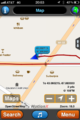
Tracklog
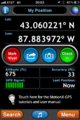
GPS reading
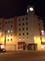
Nice building
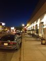
Lot of pub options
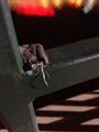
Broken dead drop
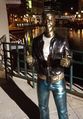
Bronze Fonz

Blood Orange Martini


Achievements
RocketMac earned the Land geohash achievement
|
RocketMac has visited an Easy Geohash
|
RocketMac earned the Pub Geohash Achievement
|