Difference between revisions of "2012-05-12 38 23"
imported>Jonas.gbl (→Participants) |
m (per Renaming Proposal) |
||
| (20 intermediate revisions by 5 users not shown) | |||
| Line 1: | Line 1: | ||
| − | |||
<!-- If you did not specify these parameters in the template, please substitute appropriate values for IMAGE, LAT, LON, and DATE (YYYY-MM-DD format) | <!-- If you did not specify these parameters in the template, please substitute appropriate values for IMAGE, LAT, LON, and DATE (YYYY-MM-DD format) | ||
| Line 10: | Line 9: | ||
}} | }} | ||
| − | + | ||
__NOTOC__ | __NOTOC__ | ||
== Location == | == Location == | ||
| Line 16: | Line 15: | ||
== Participants == | == Participants == | ||
| − | * | + | * [[User:jonas.gbl|jonas.gbl]] |
== Plans == | == Plans == | ||
| − | Well, my graticule has a lot of water and I live on the island of Evia. Last week I found an | + | Well, my graticule has a lot of water and I live on the island of Evia. |
| + | |||
| + | Last week I found an RSS feed of geohashes. Until today, all of them were on | ||
| + | water or across on continental Greece. However today's (2012-05-12 Saturday) geohash | ||
| + | was just 0.8 km off my every-Saturday cycling route (Yes, I am a geek: I cycle the | ||
| + | same route every Saturday), this one I couldn't miss. | ||
| + | |||
| + | It was too symbolic: First expedition near my Saturday cycling route on Saturday on a virgin graticule :-) ... | ||
== Expedition == | == Expedition == | ||
| − | Well, I simply started cycling my Saturday Cycling Route. After approximately 38km, I just took a left turn cycled 600 meters, turned left again, cycled 60 meters and I was almost there.I climbed the hill 20 meter on foot and I was there. I just had to do some | + | Well, I simply started cycling my Saturday Cycling Route. |
| + | |||
| + | After approximately 38km, I just took a left turn, cycled 600 meters, turned left | ||
| + | again, cycled 60 meters and I was almost there. | ||
| + | |||
| + | I climbed the hill 20 meter on foot and I was there. I just had to do some circles | ||
| + | around the geohash, because of limited GPS accuracy: There were a lot of trees. | ||
| + | |||
| + | That's all! | ||
== Tracklog == | == Tracklog == | ||
| Line 28: | Line 42: | ||
== Photos == | == Photos == | ||
| + | All photos are GPS-tagged, as a proof of being there at the correct place & date. For some reason Lat/Lon are not shown on the MetaData table. Just download the files to see the coordinates with an external application such as ACDSee. | ||
<gallery perrow="5"> | <gallery perrow="5"> | ||
| + | File:2012-05-12_38_23_p2.jpg | The geoHash spot | ||
File:2012-05-12_38_23_p1.jpg | The geoHash spot in a more artistic photo :P | File:2012-05-12_38_23_p1.jpg | The geoHash spot in a more artistic photo :P | ||
| − | File:2012-05- | + | File:2012-05-12_38_23_p3.jpg | A souvenir of the expedition |
| + | File:2012-05-12_38_23_p4.jpg | A little swim on the way back to celebrate success! | ||
</gallery> | </gallery> | ||
| Line 44: | Line 61: | ||
<!-- Add any achievement ribbons you earned below, or remove this section --> | <!-- Add any achievement ribbons you earned below, or remove this section --> | ||
| − | + | {{ Land geohash | latitude = 38 | longitude = 23 | date = 2012-05-12 | name = jonas.gbl}} | |
| − | + | {{Graticule unlocked | latitude = 38 | longitude = 23 | date = 2012-05-12 | name = jonas.gbl}} | |
| − | + | {{Easy_geohash | latitude = 38 | longitude = 23 | date = 2012-05-12 | name = jonas.gbl}} | |
| − | + | {{location|GR|H}} | |
| − | |||
| − | |||
| − | |||
| − | |||
| − | |||
| − | |||
| − | |||
| − | |||
| − | |||
| − | |||
| − | |||
| − | |||
| − | |||
| − | |||
| − | |||
| − | |||
| − | |||
| − | |||
| − | |||
| − | |||
| − | |||
| − | |||
| − | |||
| − | |||
| − | |||
| − | |||
Latest revision as of 05:38, 20 March 2024
| Sat 12 May 2012 in 38,23: 38.9260412, 23.3618228 geohashing.info google osm bing/os kml crox |
Location
In the woods near Papades, a little village of Greece
Participants
Plans
Well, my graticule has a lot of water and I live on the island of Evia.
Last week I found an RSS feed of geohashes. Until today, all of them were on water or across on continental Greece. However today's (2012-05-12 Saturday) geohash was just 0.8 km off my every-Saturday cycling route (Yes, I am a geek: I cycle the same route every Saturday), this one I couldn't miss.
It was too symbolic: First expedition near my Saturday cycling route on Saturday on a virgin graticule :-) ...
Expedition
Well, I simply started cycling my Saturday Cycling Route.
After approximately 38km, I just took a left turn, cycled 600 meters, turned left again, cycled 60 meters and I was almost there.
I climbed the hill 20 meter on foot and I was there. I just had to do some circles around the geohash, because of limited GPS accuracy: There were a lot of trees.
That's all!
Tracklog
The tracklog can be seen here in GPX format.
Photos
All photos are GPS-tagged, as a proof of being there at the correct place & date. For some reason Lat/Lon are not shown on the MetaData table. Just download the files to see the coordinates with an external application such as ACDSee.
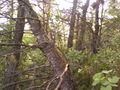
The geoHash spot
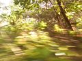
The geoHash spot in a more artistic photo :P
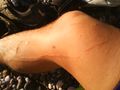
A souvenir of the expedition
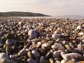
A little swim on the way back to celebrate success!


Achievements
jonas.gbl earned the Land geohash achievement
|
jonas.gbl earned the Graticule Unlocked Achievement
|
jonas.gbl has visited an Easy Geohash
|