Difference between revisions of "2012-05-13 48 2"
imported>Dunaril (→Participants) |
m (Replacing http://wiki.xkcd.com/geohashing/2012-05-12_48_2 with 2012-05-12 48 2) |
||
| (24 intermediate revisions by 3 users not shown) | |||
| Line 1: | Line 1: | ||
| − | |||
| − | |||
| − | |||
| − | |||
{{meetup graticule | {{meetup graticule | ||
| lat=48 | | lat=48 | ||
| Line 9: | Line 5: | ||
}} | }} | ||
| − | |||
__NOTOC__ | __NOTOC__ | ||
== Location == | == Location == | ||
| − | |||
| − | In Paris, 16th arrondissement. In front of the 102 avenue Kleber, fortunately on a pedestrian way between roads. | + | In Paris, 16th arrondissement, between Trocadero and the Arc de Triomphe. In front of the 102 avenue Kleber, fortunately on a pedestrian way between roads. |
== Participants == | == Participants == | ||
| − | |||
| − | |||
[[User:Dunaril|Dunaril]] and [[User:Katu|Katu]]. | [[User:Dunaril|Dunaril]] and [[User:Katu|Katu]]. | ||
== Plans == | == Plans == | ||
| − | |||
It is very rare that a geohash lands inside Paris. We plan to arrive here around 4pm. If other people are interested and would prefer to meet at another time, let us know here! | It is very rare that a geohash lands inside Paris. We plan to arrive here around 4pm. If other people are interested and would prefer to meet at another time, let us know here! | ||
== Expedition == | == Expedition == | ||
| − | |||
| − | |||
We made it, but it took longer than planned and we didn't arrive at the hash before 5pm. | We made it, but it took longer than planned and we didn't arrive at the hash before 5pm. | ||
Given the good weather, we wanted to make the trip by bike, and to make it funnier we went for the Tron achievement. | Given the good weather, we wanted to make the trip by bike, and to make it funnier we went for the Tron achievement. | ||
| + | |||
| + | Paris has a very cool bicycle sharing system, called Vélib. We had a 24 hours pass and could rent bikes at any of the hundreds of stations throughout Paris. These don't really fit to the description of "Light Cycles" though. | ||
| + | We started with a south-east trajectory, just to get a bike and let the way open and Tron-compliant for our journey back. Then we circled around our neighborhood and got to the Panthéon, from which we could start the actual trip. | ||
| + | |||
| + | We first biked around the Parc du Luxembourg, turned North to join Saint-Sulpice, and then followed a few straight lines west, up to the Eiffel Tower. Crossing the Seine between "her" and the Trocadero, we reached the hash point from the south without any difficulty, given that the Street View pictures of the street were still very actual, and the building in front of the point was quite recognizable. We then continued north on the Kleber avenue, turned east and went back to the Seine, and crossed back at the Alma bridge. We followed the quai d'Orsay and biked all the way down the Boulevard Saint-Germain, until we were close to the Panthéon again. We left the bikes at a close station and nearly got trapped into our own trail by the Sorbonne building, but the rue Cujas saved us :) We went back north and followed the rue des Ecoles, to finally climb up and get to the rue Descartes and our home, from the north, thus completing the loop. | ||
== Tracklog == | == Tracklog == | ||
| − | + | Here is [http://maps.google.com/maps/ms?ie=UTF&msa=0&msid=206353263660375712428.0004bfee3ad857a876c69 the link] to the GPS track log. Vélib is very cool and cheap, but we had to make checkpoints at the stations every 30 minutes. This reflects on the track, as we had to stop and wait five minutes each time before picking up a new bike, and the Wi-Fi tracking would make us wander all over the place. It is the same for all the photo stops, and the stop at the hashpoint. In addition, the track always cuts into buildings and rarely follows streets perfectly - but I think our actual route can still be guessed. | |
== Photos == | == Photos == | ||
| + | |||
| + | Biking through Paris is just amazing. Every street has its treasures of monuments, gardens, churches, public institutions.. In retrospect, we should have taken pictures of these little and unknown corners, instead of the most iconic monuments. However we hope you'll enjoy this little gallery :) | ||
| + | |||
<gallery> | <gallery> | ||
| + | |||
| + | Image:2012-05-13_48_2_00-44-44-146.jpg | Heavy Cycles | ||
| + | |||
| + | Image:2012-05-13_48_2_00-44-17-346.jpg | Ready to trail. | ||
| + | |||
| + | Image:2012-05-13_48_2_00-41-49-617.jpg | Ready to play! | ||
| + | |||
| + | Image:2012-05-13_48_2_00-42-14-143.jpg | In front of the Panthéon. The journey begins. | ||
| + | |||
| + | Image:2012-05-13_48_2_00-42-39-800.jpg | Parc du Luxembourg | ||
| + | |||
| + | Image:2012-05-13_48_2_Sulpice.jpg | Saint-Sulpice, and a Metallica fan we probably had met [[2012-05-12 48 2|the day before]] | ||
| + | |||
| + | Image:2012-05-13_48_2_00-43-43-557.jpg | Invalides | ||
| + | |||
| + | Image:2012-05-13_48_2_00-45-15-150.jpg | | ||
| + | |||
| + | Image:2012-05-13_48_2_00-45-45-979.jpg | Trocadéro | ||
Image:2012-05-13_48_2_17-47-16-222.jpg | Coordinates reached! [http://www.openstreetmap.org/?lat=48.86543698&lon=2.28903405&zoom=16&layers=B000FTF @48.8654,2.2890] | Image:2012-05-13_48_2_17-47-16-222.jpg | Coordinates reached! [http://www.openstreetmap.org/?lat=48.86543698&lon=2.28903405&zoom=16&layers=B000FTF @48.8654,2.2890] | ||
Image:2012-05-13_48_2_17-52-58-163.jpg | [http://www.openstreetmap.org/?lat=48.86541347&lon=2.28905476&zoom=16&layers=B000FTF @48.8654,2.2891] | Image:2012-05-13_48_2_17-52-58-163.jpg | [http://www.openstreetmap.org/?lat=48.86541347&lon=2.28905476&zoom=16&layers=B000FTF @48.8654,2.2891] | ||
| + | |||
| + | Image:2012-05-13_48_2_00-46-35-811.jpg | Assemblée Nationale - in front of the Concorde square. | ||
| + | |||
| + | Image:2012-05-13_48_2_00-47-15-766.jpg | The Socialist Party HQ, still recovering of last Sunday's presidential victory :) | ||
</gallery> | </gallery> | ||
| − | |||
| − | |||
| − | |||
| − | |||
== Achievements == | == Achievements == | ||
{{#vardefine:ribbonwidth|800px}} | {{#vardefine:ribbonwidth|800px}} | ||
| − | |||
| + | {{land geohash | ||
| + | | latitude = 48 | ||
| + | | longitude = 2 | ||
| + | | date = 2012-05-13 | ||
| + | | name = [[User:Dunaril|Dunaril]] and [[User:Katu|Katu]] | ||
| + | | image = 2012-05-13_48_2_00-45-15-150.jpg | ||
| + | }} | ||
| + | |||
| + | {{Bicycle geohash | ||
| + | | latitude = 48 | ||
| + | | longitude = 2 | ||
| + | | date = 2012-05-13 | ||
| + | | name = [[User:Dunaril|Dunaril]] and [[User:Katu|Katu]] | ||
| + | | distance = 15km | ||
| + | | image = 2012-05-13_48_2_00-41-49-617.jpg | ||
| + | }} | ||
| − | + | {{Tron | |
| − | + | | latitude = 48 | |
| + | | longitude = 2 | ||
| + | | date = 2012-05-13 | ||
| + | | tracklog = http://maps.google.com/maps/ms?ie=UTF&msa=0&msid=206353263660375712428.0004bfee3ad857a876c69 | ||
| + | | possessive = their | ||
| + | | name = [[User:Dunaril|Dunaril]] and [[User:Katu|Katu]] | ||
| + | | image = 2012-05-13 48 2 00-44-17-346.jpg | ||
| + | }} | ||
| − | [[ | + | {{consecutive geohash |
| + | | count = 2 | ||
| + | | latitude = 48 | ||
| + | | longitude = 2 | ||
| + | | date = 2012-05-12 | ||
| + | | name = [[User:Dunaril|Dunaril]] and [[User:Katu|Katu]] | ||
| + | }} | ||
| − | <!-- | + | <!-- =============== USEFUL CATEGORIES FOLLOW ================ --> |
| − | |||
| − | |||
| − | --> | ||
| − | + | [[Category:Coordinates reached]] | |
[[Category:Expeditions]] | [[Category:Expeditions]] | ||
| − | |||
[[Category:Expeditions with photos]] | [[Category:Expeditions with photos]] | ||
| − | + | {{location|FR|75}} | |
| − | |||
| − | |||
| − | |||
| − | |||
| − | |||
| − | |||
| − | |||
| − | |||
| − | |||
| − | |||
| − | |||
| − | |||
| − | |||
| − | |||
| − | |||
Latest revision as of 09:50, 19 February 2020
| Sun 13 May 2012 in 48,2: 48.8654550, 2.2888676 geohashing.info google osm bing/os kml crox |
Location
In Paris, 16th arrondissement, between Trocadero and the Arc de Triomphe. In front of the 102 avenue Kleber, fortunately on a pedestrian way between roads.
Participants
Plans
It is very rare that a geohash lands inside Paris. We plan to arrive here around 4pm. If other people are interested and would prefer to meet at another time, let us know here!
Expedition
We made it, but it took longer than planned and we didn't arrive at the hash before 5pm. Given the good weather, we wanted to make the trip by bike, and to make it funnier we went for the Tron achievement.
Paris has a very cool bicycle sharing system, called Vélib. We had a 24 hours pass and could rent bikes at any of the hundreds of stations throughout Paris. These don't really fit to the description of "Light Cycles" though. We started with a south-east trajectory, just to get a bike and let the way open and Tron-compliant for our journey back. Then we circled around our neighborhood and got to the Panthéon, from which we could start the actual trip.
We first biked around the Parc du Luxembourg, turned North to join Saint-Sulpice, and then followed a few straight lines west, up to the Eiffel Tower. Crossing the Seine between "her" and the Trocadero, we reached the hash point from the south without any difficulty, given that the Street View pictures of the street were still very actual, and the building in front of the point was quite recognizable. We then continued north on the Kleber avenue, turned east and went back to the Seine, and crossed back at the Alma bridge. We followed the quai d'Orsay and biked all the way down the Boulevard Saint-Germain, until we were close to the Panthéon again. We left the bikes at a close station and nearly got trapped into our own trail by the Sorbonne building, but the rue Cujas saved us :) We went back north and followed the rue des Ecoles, to finally climb up and get to the rue Descartes and our home, from the north, thus completing the loop.
Tracklog
Here is the link to the GPS track log. Vélib is very cool and cheap, but we had to make checkpoints at the stations every 30 minutes. This reflects on the track, as we had to stop and wait five minutes each time before picking up a new bike, and the Wi-Fi tracking would make us wander all over the place. It is the same for all the photo stops, and the stop at the hashpoint. In addition, the track always cuts into buildings and rarely follows streets perfectly - but I think our actual route can still be guessed.
Photos
Biking through Paris is just amazing. Every street has its treasures of monuments, gardens, churches, public institutions.. In retrospect, we should have taken pictures of these little and unknown corners, instead of the most iconic monuments. However we hope you'll enjoy this little gallery :)
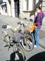
Heavy Cycles
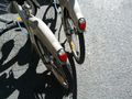
Ready to trail.
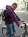
Ready to play!
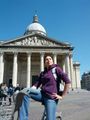
In front of the Panthéon. The journey begins.

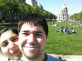
Parc du Luxembourg
Saint-Sulpice, and a Metallica fan we probably had met the day before
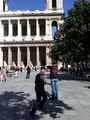
Invalides
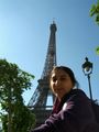
Trocadéro
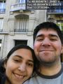
Coordinates reached! @48.8654,2.2890

Assemblée Nationale - in front of the Concorde square.

The Socialist Party HQ, still recovering of last Sunday's presidential victory :)


Achievements
Dunaril and Katu earned the Land geohash achievement
|
Dunaril and Katu earned the Bicycle geohash achievement
|
Dunaril and Katu earned the Tron achievement
|
Dunaril and Katu earned the Consecutive geohash achievement
|