Difference between revisions of "2012-05-21 59 18"
imported>Cjk ([live] Happy geohashing day!) |
imported>FippeBot m (Location) |
||
| (14 intermediate revisions by 2 users not shown) | |||
| Line 1: | Line 1: | ||
| − | + | {| width="100%" border=0 cellpadding=0 cellspacing=0 style="border: 0; border-collapse: collapse; border-spacing: 0; margin: 0; padding: 0" | |
| − | + | | align="left" valign="top" style="padding: 0.5em 1em 0.5em 0" | [[Image:2012-05-21 59 18 20-34-39-219.jpg|border|467px]] | |
| − | -- | + | |
| − | {{meetup graticule | + | | align="right" valign="top" | {{meetup graticule |
| lat=59 | | lat=59 | ||
| lon=18 | | lon=18 | ||
| date=2012-05-21 | | date=2012-05-21 | ||
| + | | graticule_name=Stockholm | ||
| + | | graticule_link=Stockholm, Sweden | ||
}} | }} | ||
| − | + | |} | |
| + | |||
__NOTOC__ | __NOTOC__ | ||
| + | |||
== Location == | == Location == | ||
In a field close to Garnsviken, five miles north-northwest of Åkersberga. | In a field close to Garnsviken, five miles north-northwest of Åkersberga. | ||
| Line 16: | Line 20: | ||
== Participants == | == Participants == | ||
* [[User:Per S|Per S]] | * [[User:Per S|Per S]] | ||
| + | * [[User:Cjk|Cjk]] | ||
| + | * [[User:TheNuclearScientist|TheNuclearScientist]] | ||
== Plans == | == Plans == | ||
| Line 21: | Line 27: | ||
== Expedition == | == Expedition == | ||
| − | + | *Happy geohashing day! -- [[User:Cjk|Cjk]] [http://www.openstreetmap.org/?lat=59.54337041&lon=18.26265701&zoom=16&layers=B000FTF @59.5434,18.2627] 20:25, 21 May 2012 (CEST) | |
| + | === Per S === | ||
| + | I went there in a Volvo C30 after work. I tried to make the Tron achievement by planning my route carefully, but I failed. After parking the car, I went the wrong direction and had to intersect my own path to get back to the car. I also went into a dead end while driving back, just to make sure there was no chance of claiming the Tron achievement. | ||
| + | The hash point was in a field (as usual :). It was a beautiful place close to the water and the evening sun lit up the fields nicely. I had to pass several electric fences to get to the hash point, but there were no animals in the fields, so I don't think the fences were turned on. | ||
| + | |||
| + | I had talked to Cjk earlier and knew he was also going, so I built a little cairn to mark the spot. I also put up a poster on a tree stump close by. | ||
| + | |||
| + | === Cjk and TheNuclearScientist === | ||
| + | Cjk was working a bit late and biked home to TheNuclearScientist. I messaged Per S and he called me up but he was already at the hash, attempting his TRON. TheNuclearScientist was driving to the Forsmark Nuclear powerplant this evening anyway and the hash was not far from his path anyway so it was decided to try it. After some food and packing we were off. Just followed the E18 and then it was just a 2 km drive to the spot. Had some trouble finding a good spot to park in order to walk to the spot without going onto private property. | ||
| + | |||
| + | We got out near a farm house and started walking to the hash. Found it very quickly and we saw the cairn that Per S had built. Snapped some pics and this was TheNuclearScientist's first hash that he actually visited. His last one, he was only along for safety by the side of the ice. | ||
| + | |||
| + | The sun was setting so tried to get some nice panoramas. We went back to the car and I was dropped off by the bus stop and took public transport home to Stockholm. | ||
| − | |||
== Tracklog == | == Tracklog == | ||
<!-- if your GPS device keeps a log, you may post a link here --> | <!-- if your GPS device keeps a log, you may post a link here --> | ||
| + | Cjk's [https://maps.google.com/maps/ms?msa=0&msid=209560846421673743077.0004c09125ff792a01b54 map] | ||
| + | == Photos == | ||
| + | === Per S === | ||
| + | <gallery widths=117px perrow="5"> | ||
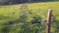
| + | Image:2012-05-21 59 18 1 Fence.jpg | Had to pass a lot of these | ||
| + | Image:2012-05-21 59 18 2 Coordinates Reached.png | Coordinates Reached | ||
| + | Image:2012-05-21 59 18 3 Cairn.jpg | Cairn | ||
| + | Image:2012-05-21 59 18 4 Field.jpg | Field | ||
| + | Image:2012-05-21 59 18 5 Field.jpg | Field | ||
| + | Image:2012-05-21 59 18 6 Field.jpg | Field | ||
| + | Image:2012-05-21 59 18 7 Poster.jpg | Poster | ||
| + | </gallery> | ||
| − | == | + | === Cjk === |
| − | < | + | <gallery widths=117px perrow="5"> |
| − | Image: | + | Image:2012-05-21_59_18_20-33-16-823.jpg | TheNuclearScientist [http://www.openstreetmap.org/?lat=59.54340000&lon=18.26270000&zoom=16&layers=B000FTF @59.5434,18.2627] |
| − | -- | + | Image:2012-05-21_59_18_20-34-39-219.jpg | Me [http://www.openstreetmap.org/?lat=59.54340000&lon=18.26270000&zoom=16&layers=B000FTF @59.5434,18.2627] |
| − | + | Image:2012-05-21_59_18_20-35-06-169.jpg | [http://www.openstreetmap.org/?lat=59.54370000&lon=18.26250000&zoom=16&layers=B000FTF @59.5437,18.2625] | |
| + | Image:2012-05-21_59_18_20-36-35-505.jpg | Orange [http://www.openstreetmap.org/?lat=59.54340000&lon=18.26270000&zoom=16&layers=B000FTF @59.5434,18.2627] | ||
| + | Image:2012-05-21_59_18_20-37-57-057.jpg | Panorama 1 | ||
| + | Image:2012-05-21_59_18_20-39-14-001.jpg | Panorama 2 | ||
| + | Image:2012-05-21_59_18_20-51-14-154.jpg | Sunset, bus stop [http://www.openstreetmap.org/?lat=59.56000000&lon=18.23150000&zoom=16&layers=B000FTF @59.5600,18.2315] | ||
</gallery> | </gallery> | ||
== Achievements == | == Achievements == | ||
| − | {{#vardefine:ribbonwidth| | + | {{#vardefine:ribbonwidth|100%}} |
| − | + | ||
| + | {| | ||
| + | |{{Geohashing Day | ||
| + | | latitude = 59 | ||
| + | | longitude = 18 | ||
| + | | year = 2012 | ||
| + | | coorddate = 2012-05-21 | ||
| + | | name = [[User:Per S|Per S]], [[User:Cjk|Cjk]] and TheNuclearScientist | ||
| + | | image = 2012-05-21_59_18_20-34-39-219.jpg | ||
| + | }} | ||
| − | + | |} | |
| − | + | {{drag-along | latitude = 59 | longitude = 18 | date = 2012-05-21 | partner = [[User:TheNuclearScientist|TheNuclearScientist]] | name = [[User:Cjk|Cjk]] | image = 2012-05-21_59_18_20-33-16-823.jpg}} | |
| − | |||
| − | |||
[[Category:Expeditions]] | [[Category:Expeditions]] | ||
| − | |||
[[Category:Expeditions with photos]] | [[Category:Expeditions with photos]] | ||
| − | |||
| − | |||
| − | |||
| − | |||
| − | |||
[[Category:Coordinates reached]] | [[Category:Coordinates reached]] | ||
| − | + | {{location|SE|AB}} | |
| − | |||
| − | |||
| − | |||
| − | |||
| − | |||
| − | |||
| − | |||
| − | |||
| − | |||
Latest revision as of 04:09, 13 August 2019

|
| ||||||
Location
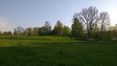
In a field close to Garnsviken, five miles north-northwest of Åkersberga.
Participants
Plans
I'm planning to go there after work, since it's Geohashing Day. -- Per S
Expedition
- Happy geohashing day! -- Cjk @59.5434,18.2627 20:25, 21 May 2012 (CEST)
Per S
I went there in a Volvo C30 after work. I tried to make the Tron achievement by planning my route carefully, but I failed. After parking the car, I went the wrong direction and had to intersect my own path to get back to the car. I also went into a dead end while driving back, just to make sure there was no chance of claiming the Tron achievement.
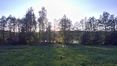
The hash point was in a field (as usual :). It was a beautiful place close to the water and the evening sun lit up the fields nicely. I had to pass several electric fences to get to the hash point, but there were no animals in the fields, so I don't think the fences were turned on.
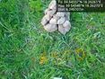
I had talked to Cjk earlier and knew he was also going, so I built a little cairn to mark the spot. I also put up a poster on a tree stump close by.
Cjk and TheNuclearScientist
Cjk was working a bit late and biked home to TheNuclearScientist. I messaged Per S and he called me up but he was already at the hash, attempting his TRON. TheNuclearScientist was driving to the Forsmark Nuclear powerplant this evening anyway and the hash was not far from his path anyway so it was decided to try it. After some food and packing we were off. Just followed the E18 and then it was just a 2 km drive to the spot. Had some trouble finding a good spot to park in order to walk to the spot without going onto private property.
We got out near a farm house and started walking to the hash. Found it very quickly and we saw the cairn that Per S had built. Snapped some pics and this was TheNuclearScientist's first hash that he actually visited. His last one, he was only along for safety by the side of the ice.
The sun was setting so tried to get some nice panoramas. We went back to the car and I was dropped off by the bus stop and took public transport home to Stockholm.
Tracklog
Cjk's map
Photos
Per S
Had to pass a lot of these
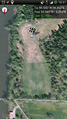
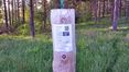
Coordinates Reached
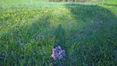
Cairn
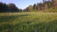
Field
Field
Field
Poster


Cjk
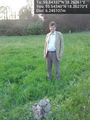
TheNuclearScientist @59.5434,18.2627
Orange @59.5434,18.2627
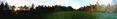
Panorama 1
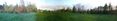
Panorama 2
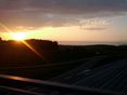
Sunset, bus stop @59.5600,18.2315


Achievements
|
Cjk earned the Drag-along achievement
|