Difference between revisions of "2012-05-22 48 11"
imported>Zertrin m |
m (Location correction) |
||
| (3 intermediate revisions by 3 users not shown) | |||
| Line 1: | Line 1: | ||
| − | |||
| − | |||
| − | |||
| − | |||
{{meetup graticule | {{meetup graticule | ||
| lat=48 | | lat=48 | ||
| Line 9: | Line 5: | ||
}} | }} | ||
| − | |||
__NOTOC__ | __NOTOC__ | ||
== Location == | == Location == | ||
| Line 20: | Line 15: | ||
== Participants == | == Participants == | ||
* [[User:Zertrin|Zertrin]] | * [[User:Zertrin|Zertrin]] | ||
| + | * [[User:DerFlob|DerFlob]] | ||
== Plans == | == Plans == | ||
| Line 31: | Line 27: | ||
Today's hash seemed quite easy to reach. Thank to the highway 95 I could be in the area of the hash in 20 minutes by car. The journey by car went uneventful, I parked in front of a Deutsche Post logistic center and continued by feet. | Today's hash seemed quite easy to reach. Thank to the highway 95 I could be in the area of the hash in 20 minutes by car. The journey by car went uneventful, I parked in front of a Deutsche Post logistic center and continued by feet. | ||
| − | The pathway began by going along some pastures with horses, and then enter the forest. Then I turned right at the first crossroads and followed the path. I knew that I had to look for a path (or at least that's how it looked like on google maps and OpenStreetMap) on my right that was due to fork from the main pathway about 330m after the crossroad. But as my geolocalisation indicated that I had been too far, without having seen any type of path on my right, I understood that in the end it wasn't going to be as easy as planned. Instead of a path there was just some "direction" where trees seemed to have been cut a long time ago (5th photo below), and I decided to follow this direction which coincided with the path line on google maps. The progression wasn't very easy at the beginning, because there were a lot of dead cut wood and I had to be careful of where I stepped (see 6th photo below). A little after It went relatively better, and it was just the typical difficulty of wandering | + | The pathway began by going along some pastures with horses, and then enter the forest. Then I turned right at the first crossroads and followed the path. I knew that I had to look for a path (or at least that's how it looked like on google maps and OpenStreetMap) on my right that was due to fork from the main pathway about 330m after the crossroad. But as my geolocalisation indicated that I had been too far, without having seen any type of path on my right, I understood that in the end it wasn't going to be as easy as planned. Instead of a path there was just some "direction" where trees seemed to have been cut a long time ago (5th photo below), and I decided to follow this direction which coincided with the path line on google maps. The progression wasn't very easy at the beginning, because there were a lot of dead cut wood and I had to be careful of where I stepped (see 6th photo below). A little after It went relatively better, and it was just the typical difficulty of wandering off the paths in a forest. |
I had some difficulties locating the exact location of the hash, as I thought I could locate it relative to the path I expected to encounter but which was totally non-existant. After some wanderings I elected the closest attempt to center the accuracy circle on the hash coords, took some pictures and headed back from the hash at around 3:30 p.m. as sounds of lumberjacks cutting wood began to be closer from where I was. | I had some difficulties locating the exact location of the hash, as I thought I could locate it relative to the path I expected to encounter but which was totally non-existant. After some wanderings I elected the closest attempt to center the accuracy circle on the hash coords, took some pictures and headed back from the hash at around 3:30 p.m. as sounds of lumberjacks cutting wood began to be closer from where I was. | ||
| Line 37: | Line 33: | ||
The journey back went uneventful and I even managed to attend the only lecture I had today at 4:45 p.m. | The journey back went uneventful and I even managed to attend the only lecture I had today at 4:45 p.m. | ||
| − | == | + | === DerFlob === |
| − | + | I started my tour at 3:15 p.m., mostly driving along or near the Isar river. After about 28 km I reached the hash at about 4:45 p.m. On the last 30 metres or so I went by foot, my GPS misguided me a bit. But luckily I spotted Zertrin's marker, helping me successfully reaching the spot. | |
| + | On my way driving through the forest, to and back from the hash, I crossed some wild boars with piglets search for food near the roads. Probably both times the same family of boars, quickly running away as I tried to get some closer pictures. | ||
| + | Also on my way back I came into some passing rain showers, for which I luckily packed my rain jacket. | ||
| + | All in all, I cycled about 55 km, which is currently pretty much the maximum I can go comfortably. | ||
== Photos == | == Photos == | ||
| − | |||
| − | |||
| − | |||
=== Zertrin === | === Zertrin === | ||
<gallery perrow="6"> | <gallery perrow="6"> | ||
| Line 59: | Line 55: | ||
Image:2012-05-22 48 11 On the way back.JPG | A wood chair I didn't notice on the way to the hash | Image:2012-05-22 48 11 On the way back.JPG | A wood chair I didn't notice on the way to the hash | ||
</gallery> | </gallery> | ||
| + | |||
| + | === DerFlob === | ||
| + | <gallery perrow="6"> | ||
| + | Image:2012-05-22 48 11 Flob 1.jpg | Some wild boars I came across | ||
| + | Image:2012-05-22 48 11 Flob 2.jpg | Zertrin's marker, which helped me more than my GPS to find the spot :) | ||
| + | Image:2012-05-22 48 11 Flob 3.jpg | Spot within GPS accuracy. You can see how my GPS mislead me at first | ||
| + | Image:2012-05-22 48 11 Flob 4.jpg | Stupid (not so) grin | ||
| + | Image:2012-05-22 48 11 Flob 5.jpg | Quite nice view across the Isar, with the [https://de.wikipedia.org/wiki/Wasserkraftwerk_Pullach Wasserkraftwerk Pullach] | ||
| + | </gallery> | ||
| + | |||
== Achievements == | == Achievements == | ||
| Line 64: | Line 70: | ||
<!-- Add any achievement ribbons you earned below, or remove this section --> | <!-- Add any achievement ribbons you earned below, or remove this section --> | ||
| − | |||
| − | |||
| − | |||
| − | |||
| − | |||
| − | |||
| − | |||
| − | |||
[[Category:Expeditions]] | [[Category:Expeditions]] | ||
[[Category:Expeditions with photos]] | [[Category:Expeditions with photos]] | ||
| − | |||
| − | |||
| − | |||
| − | |||
| − | |||
[[Category:Coordinates reached]] | [[Category:Coordinates reached]] | ||
| − | + | {{location|DE|BY|M}} | |
| − | |||
| − | |||
| − | |||
| − | |||
| − | |||
| − | |||
| − | |||
| − | |||
Latest revision as of 20:14, 16 May 2020
| Tue 22 May 2012 in 48,11: 48.0074559, 11.4330666 geohashing.info google osm bing/os kml crox |
Location
In the south area of the Forstenrieder Park, in the middle of the trees, about 400 meters from the nearest pathway.

The hash is located at A in the picture above.
Participants
Plans
I will go there by bike. ETA is 4:30 p.m. --DerFlob 14:35, 21 May 2012 (EDT)
- Tomorrow is Geohashing Day, so I'll try to get there, but in any case I won't be able to do it at 4:30 PM (I have a lecture), so either way before or way after that time (I don't know yet when I'll be motivated tomorrow ^^). As the weather doesn't seem to be really great, I may choose to go there by car. — Zertrin 19:05, 21 May 2012 (EDT)
- Isn't Geohashing Day on May 21? Unfortunately I can't go earlier, because I have lectures myself and wouldn't want to go later, because of the weather as you mentioned getting worse. --DerFlob 04:01, 22 May 2012 (EDT)
- Ach, you're right, I was mistaken with yesterday's date. Anyway, I reached the coords. — Zertrin 11:02, 22 May 2012 (EDT)
- Isn't Geohashing Day on May 21? Unfortunately I can't go earlier, because I have lectures myself and wouldn't want to go later, because of the weather as you mentioned getting worse. --DerFlob 04:01, 22 May 2012 (EDT)
Expedition
Zertrin
Today's hash seemed quite easy to reach. Thank to the highway 95 I could be in the area of the hash in 20 minutes by car. The journey by car went uneventful, I parked in front of a Deutsche Post logistic center and continued by feet.
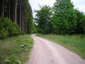
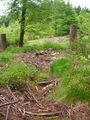
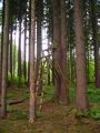
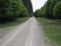
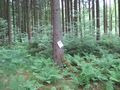
The pathway began by going along some pastures with horses, and then enter the forest. Then I turned right at the first crossroads and followed the path. I knew that I had to look for a path (or at least that's how it looked like on google maps and OpenStreetMap) on my right that was due to fork from the main pathway about 330m after the crossroad. But as my geolocalisation indicated that I had been too far, without having seen any type of path on my right, I understood that in the end it wasn't going to be as easy as planned. Instead of a path there was just some "direction" where trees seemed to have been cut a long time ago (5th photo below), and I decided to follow this direction which coincided with the path line on google maps. The progression wasn't very easy at the beginning, because there were a lot of dead cut wood and I had to be careful of where I stepped (see 6th photo below). A little after It went relatively better, and it was just the typical difficulty of wandering off the paths in a forest.
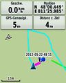
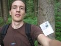
I had some difficulties locating the exact location of the hash, as I thought I could locate it relative to the path I expected to encounter but which was totally non-existant. After some wanderings I elected the closest attempt to center the accuracy circle on the hash coords, took some pictures and headed back from the hash at around 3:30 p.m. as sounds of lumberjacks cutting wood began to be closer from where I was.
The journey back went uneventful and I even managed to attend the only lecture I had today at 4:45 p.m.
DerFlob
I started my tour at 3:15 p.m., mostly driving along or near the Isar river. After about 28 km I reached the hash at about 4:45 p.m. On the last 30 metres or so I went by foot, my GPS misguided me a bit. But luckily I spotted Zertrin's marker, helping me successfully reaching the spot. On my way driving through the forest, to and back from the hash, I crossed some wild boars with piglets search for food near the roads. Probably both times the same family of boars, quickly running away as I tried to get some closer pictures. Also on my way back I came into some passing rain showers, for which I luckily packed my rain jacket. All in all, I cycled about 55 km, which is currently pretty much the maximum I can go comfortably.
Photos
Zertrin
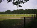
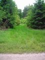
Before entering the forest, there were some horses in pastures
moar horses...
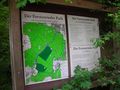
Map of the forest, we are merely at the bottom of it
A pathway by Google
Another pathway by Google
This is what Google Maps draws as a "path"...
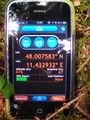
Coords reached (within accuracy range of the phone)

Zertrin at the coords
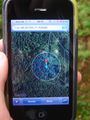
Google Maps at the coords
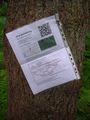
Active Geohasher poster
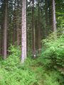
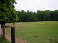
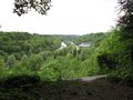
The environment of the hash
A wood chair I didn't notice on the way to the hash


DerFlob
Some wild boars I came across
Zertrin's marker, which helped me more than my GPS to find the spot :)
Spot within GPS accuracy. You can see how my GPS mislead me at first
Stupid (not so) grin
Quite nice view across the Isar, with the Wasserkraftwerk Pullach


