Difference between revisions of "2012-06-08 45 13"
imported>LarsVegas m |
imported>FippeBot m (Location) |
||
| (6 intermediate revisions by 2 users not shown) | |||
| Line 1: | Line 1: | ||
| − | |||
| − | |||
| − | |||
| − | |||
| − | |||
| − | |||
| − | |||
| − | |||
| − | |||
{{meetup graticule | {{meetup graticule | ||
| lat=45 | | lat=45 | ||
| lon=13 | | lon=13 | ||
| date=2012-06-08 | | date=2012-06-08 | ||
| − | }} | + | | graticule_name=Trieste |
| + | | graticule_link=Trieste, Italy}} | ||
| − | |||
__NOTOC__ | __NOTOC__ | ||
== Location == | == Location == | ||
| − | |||
| − | + | The hash was on a small grassy platform in the hills above Lucija, Slovenia. The hillside is a mixture of gardens, fields, orchards and houses. | |
== Participants == | == Participants == | ||
| Line 25: | Line 15: | ||
* [[User:LarsVegas|Lars Vegas]] | * [[User:LarsVegas|Lars Vegas]] | ||
| − | == | + | == Expedition == |
| − | |||
| − | + | I was on holidays in [[Pula,_Croatia|Pula, Croatia]] for two weeks. But the graticule consists of approx. 90% water and there wasn't any land-bound hash during that time. I would have liked to earn a virgin graticule achievement. But the chances were low, so I was also looking for easily accessible hashes in the [[Trieste,_Italy|Trieste, Italy]] or [[Rijeka,_Croatia|Rijeka, Croatia]] graticule. And on the day of our departure, the Trieste graticule had a hash just 2km off our chosen route. | |
| − | |||
| − | + | Unfortunately the built-in GPS of my car didn't allow to enter the coordinates directly, so I had to select the place via map, comparing it to the peeron map image on my notebook (courtesy of the camp site's free Wi-Fi). I had my Garmin for the last few meters and that worked fine. We left Pula, Croatia, were we spent two wonderful sunny weeks on a camp site at the sea at 09:00 AM. There was no waiting nor real checking at the border, though I didn't take any photos. But I have a receipt of the Croation highway toll booth that shows that I was in Croatia in the morning. | |
| − | + | After about 90 min of smooth driving on a brand new 4 lane highway with beautiful Mediterranean countryside on both sides (rolling hills, deep gorges, cypresses, ...), the car's GPS showed me the way up to about 60m of the final location. Because I didn't know where and how the path ended, I decided to park in a place where I could easily turn (would have liked to earn the [[Speed_racer_achievement|max speed award]], but the place was off the road anyway). My wife and the kids were so nice to give me 15min to search for the exact place which was easily accessible. I took some images of the surrounding area and went back to the car for a short trip to the next (and final) beach of this vacation (in Piran). | |
| − | |||
== Photos == | == Photos == | ||
| − | |||
| − | |||
| − | |||
<gallery perrow="5"> | <gallery perrow="5"> | ||
Image:2012-06-08_45_13_Lucija_Slovenia.jpg | The town of Lucija, Slovenia, to which the hashplace belongs. | Image:2012-06-08_45_13_Lucija_Slovenia.jpg | The town of Lucija, Slovenia, to which the hashplace belongs. | ||
| Line 45: | Line 29: | ||
Image:2012-06-08_45_13_Hills.jpg | Hills above the town. | Image:2012-06-08_45_13_Hills.jpg | Hills above the town. | ||
Image:2012-06-08_45_13_PathToSpot.jpg | The path to the spot. | Image:2012-06-08_45_13_PathToSpot.jpg | The path to the spot. | ||
| − | Image:2012-06-08_45_13_GPS_Proof_LarsVegas. | + | Image:2012-06-08_45_13_GPS_Proof_LarsVegas.jpg | I was there! My first geohash abroad. |
</gallery> | </gallery> | ||
== Achievements == | == Achievements == | ||
{{#vardefine:ribbonwidth|800px}} | {{#vardefine:ribbonwidth|800px}} | ||
| − | |||
| − | + | {{land geohash | |
| + | | latitude = 45 | ||
| + | | longitude = 13 | ||
| + | | date = 2012-06-08 | ||
| + | | name = [[User:LarsVegas|Lars Vegas]] | ||
| + | }} | ||
{{Border geohash achievement | latitude = 45 | longitude = 13 | date = 2012-06-08 | country1 = Croatia | country2 = Slovenia | name = Lars Vegas}} | {{Border geohash achievement | latitude = 45 | longitude = 13 | date = 2012-06-08 | country1 = Croatia | country2 = Slovenia | name = Lars Vegas}} | ||
| − | |||
| − | |||
| − | |||
[[Category:Expeditions]] | [[Category:Expeditions]] | ||
[[Category:Coordinates reached]] | [[Category:Coordinates reached]] | ||
| − | |||
| − | |||
| − | |||
| − | |||
| − | |||
| − | |||
| − | |||
| − | |||
| − | |||
| − | |||
| − | |||
[[Category:Expeditions with photos]] | [[Category:Expeditions with photos]] | ||
| − | + | {{location|SI|090}} | |
| − | |||
| − | |||
| − | |||
| − | |||
| − | |||
| − | |||
| − | |||
| − | |||
| − | |||
| − | |||
| − | |||
| − | |||
| − | |||
| − | |||
| − | |||
Latest revision as of 04:54, 6 August 2019
| Fri 8 Jun 2012 in Trieste: 45.5125909, 13.6141131 geohashing.info google osm bing/os kml crox |
Location
The hash was on a small grassy platform in the hills above Lucija, Slovenia. The hillside is a mixture of gardens, fields, orchards and houses.
Participants
Expedition
I was on holidays in Pula, Croatia for two weeks. But the graticule consists of approx. 90% water and there wasn't any land-bound hash during that time. I would have liked to earn a virgin graticule achievement. But the chances were low, so I was also looking for easily accessible hashes in the Trieste, Italy or Rijeka, Croatia graticule. And on the day of our departure, the Trieste graticule had a hash just 2km off our chosen route.
Unfortunately the built-in GPS of my car didn't allow to enter the coordinates directly, so I had to select the place via map, comparing it to the peeron map image on my notebook (courtesy of the camp site's free Wi-Fi). I had my Garmin for the last few meters and that worked fine. We left Pula, Croatia, were we spent two wonderful sunny weeks on a camp site at the sea at 09:00 AM. There was no waiting nor real checking at the border, though I didn't take any photos. But I have a receipt of the Croation highway toll booth that shows that I was in Croatia in the morning.
After about 90 min of smooth driving on a brand new 4 lane highway with beautiful Mediterranean countryside on both sides (rolling hills, deep gorges, cypresses, ...), the car's GPS showed me the way up to about 60m of the final location. Because I didn't know where and how the path ended, I decided to park in a place where I could easily turn (would have liked to earn the max speed award, but the place was off the road anyway). My wife and the kids were so nice to give me 15min to search for the exact place which was easily accessible. I took some images of the surrounding area and went back to the car for a short trip to the next (and final) beach of this vacation (in Piran).
Photos
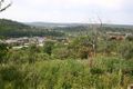
The town of Lucija, Slovenia, to which the hashplace belongs.
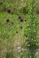
The exact place.
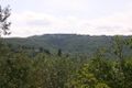
Hills above the town.
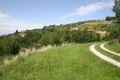
The path to the spot.
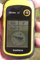
I was there! My first geohash abroad.


Achievements
Lars Vegas earned the Land geohash achievement
|
Lars Vegas earned the Border geohash achievement
|