Difference between revisions of "2012-06-08 55 13"
From Geohashing
imported>Fasanen (Created page with "{{meetup graticule | lat=55 | lon=13 | date=2012-06-08 }} __NOTOC__ == Location == == Participants == Fasanen == Plans == == Expedition == == Photos == ...") |
imported>FippeBot m (Location) |
||
| (3 intermediate revisions by one other user not shown) | |||
| Line 8: | Line 8: | ||
__NOTOC__ | __NOTOC__ | ||
== Location == | == Location == | ||
| + | A klick east of Rydsgårds Gods. | ||
== Participants == | == Participants == | ||
[[User:Fasanen|Fasanen]] | [[User:Fasanen|Fasanen]] | ||
| − | |||
| − | |||
| − | |||
== Expedition == | == Expedition == | ||
| + | I was sitting home working and about lunch time I had to stretch my leg, so why not visit the quite nearby Geohash? My Android device was out of batteries so I had to fire up my trusty old Garmin device instead. There was a heavy rain when I left home. When I got to the gravel road leading up to the geohash, it stopped. There where a tremendous amount of pheasants here. I got one meter from the hash while still sitting in the car, but this was about stretching legs, so I got out of the car and walked about for a while before going home and continued work. | ||
| + | BTW I noticed this was expedition #100 for 55 13, so it should count as some sort of milestone despite its gloominess. | ||
== Photos == | == Photos == | ||
<gallery perrow="4"> | <gallery perrow="4"> | ||
| + | File:201206085513_01.JPG| Wheels on hash | ||
| + | </gallery> | ||
| − | + | ==Track log== | |
| + | To be added | ||
== Achievements == | == Achievements == | ||
{{#vardefine:ribbonwidth|800px}} | {{#vardefine:ribbonwidth|800px}} | ||
{{land geohash | latitude=55 | longitude=13 | date=2012-06-08 | name=Fasanen}} | {{land geohash | latitude=55 | longitude=13 | date=2012-06-08 | name=Fasanen}} | ||
| + | {{Speed racer | ||
| + | | latitude = 55 | ||
| + | | longitude = 13 | ||
| + | | date = 2012-06-08 | ||
| + | | name = Fasanen | ||
| + | | speed = 10 km/h | ||
| + | }} | ||
| Line 34: | Line 44: | ||
[[Category:Coordinates reached]] | [[Category:Coordinates reached]] | ||
[[Category:Sweden]] | [[Category:Sweden]] | ||
| + | {{location|SE|M}} | ||
Latest revision as of 04:27, 13 August 2019
| Fri 8 Jun 2012 in 55,13: 55.5125909, 13.6141131 geohashing.info google osm bing/os kml crox |
Location
A klick east of Rydsgårds Gods.
Participants
Expedition
I was sitting home working and about lunch time I had to stretch my leg, so why not visit the quite nearby Geohash? My Android device was out of batteries so I had to fire up my trusty old Garmin device instead. There was a heavy rain when I left home. When I got to the gravel road leading up to the geohash, it stopped. There where a tremendous amount of pheasants here. I got one meter from the hash while still sitting in the car, but this was about stretching legs, so I got out of the car and walked about for a while before going home and continued work.
BTW I noticed this was expedition #100 for 55 13, so it should count as some sort of milestone despite its gloominess.
Photos
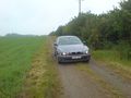
Wheels on hash

Track log
To be added
Achievements
Fasanen earned the Land geohash achievement
|

Fasanen earned the Speed racer achievement
by passing through the (55, 13) geohash on 2012-06-08 at 10 km/h.