Difference between revisions of "2012-06-18 40 -89"
imported>Dvdllr (New potential expedition) |
imported>FippeBot m (Location) |
||
| (2 intermediate revisions by one other user not shown) | |||
| Line 1: | Line 1: | ||
| − | + | __NOTOC__ | |
| − | |||
| − | |||
| − | |||
| − | |||
| − | |||
| − | |||
| − | |||
| − | |||
| − | |||
{{meetup graticule | {{meetup graticule | ||
| lat=40 | | lat=40 | ||
| Line 14: | Line 5: | ||
| date=2012-06-18 | | date=2012-06-18 | ||
}} | }} | ||
| − | |||
| − | |||
| − | |||
== Location == | == Location == | ||
| − | + | A rocky culvert drain, just off the road, in a business park in Morton. | |
== Participants == | == Participants == | ||
| − | + | * [[User:Dvdllr|Dvdllr]] | |
| − | |||
| − | |||
| − | |||
| − | |||
== Expedition == | == Expedition == | ||
| − | + | After getting off work and doing a few errands around Morton, I swung by with only my Active Geohasher flyer to show me where to go. I could see the location was right on top of a grey area amongst green, which I correctly surmised were rocks, but incorrectly surmised their purpose (I had though it might have been a landscaping thing). So, I didn't need a GPS to get me to the correct location. I pulled into the drive for the electrical relay station, the southerly of the two lots the location was in-between. That's when I found it was a culvert outlet. I just walked over, stood on the rocks, and took some pictures with my telephone. As culverts tend to gather garbage, I thought I'd do my geotrashing duty and pick up some bottles and cans - I didn't have a bag so that's the extent of what I was willing and able to clean up. That was it, and then I left! | |
| − | |||
| − | |||
| − | |||
== Photos == | == Photos == | ||
| − | |||
| − | |||
| − | |||
<gallery perrow="5"> | <gallery perrow="5"> | ||
| + | Image:2012-06-18 40 -89 1.jpg | The spot | ||
| + | Image:2012-06-18 40 -89 2.jpg | Proof of location (and date) | ||
| + | Image:2012-06-18 40 -89 3.jpg | Proof of me | ||
| + | Image:2012-06-18 40 -89 4.jpg | Shadow | ||
| + | Image:2012-06-18 40 -89 5.jpg | Powerlines to the south | ||
| + | Image:2012-06-18 40 -89 6.jpg | Butch's Pizza to the north | ||
| + | Image:2012-06-18 40 -89 7.jpg | Some garbage | ||
| + | Image:2012-06-18 40 -89 8.jpg | Sunbleached | ||
| + | Image:2012-06-18 40 -89 9.jpg | Road | ||
</gallery> | </gallery> | ||
== Achievements == | == Achievements == | ||
{{#vardefine:ribbonwidth|800px}} | {{#vardefine:ribbonwidth|800px}} | ||
| − | + | {{land geohash | |
| + | | latitude = 40 | ||
| + | | longitude = -89 | ||
| + | | date = 2012-06-18 | ||
| + | | name = [[User:Dvdllr|Dvdllr]] | ||
| + | }} | ||
| + | {{A Tale of Two Hashes challenge | ||
| + | | latitude = 40 | ||
| + | | longitude = -89 | ||
| + | | date = 2012-06-18 | ||
| + | | name = [[User:Dvdllr|Dvdllr]] | ||
| + | | place = [http://en.wikipedia.org/wiki/Flint_%28disambiguation%29#Places Flint] | ||
| + | }} | ||
| + | {{Geotrash | ||
| − | + | | latitude = 40 | |
| − | + | | longitude = -89 | |
| − | [[ | + | | date = 2012-06-18 |
| + | | name = [[User:Dvdllr|Dvdllr]] | ||
| − | + | }} | |
| − | + | {{No_batteries_geohash | |
| − | [[ | + | |
| − | + | | latitude = 40 | |
| + | | longitude = -89 | ||
| + | | date = 2012-06-18 | ||
| + | | name = [[User:Dvdllr|Dvdllr]] | ||
| + | }} | ||
| − | |||
[[Category:Expeditions]] | [[Category:Expeditions]] | ||
| − | |||
[[Category:Expeditions with photos]] | [[Category:Expeditions with photos]] | ||
| − | |||
[[Category:Expedition without GPS]] | [[Category:Expedition without GPS]] | ||
| − | |||
| − | |||
| − | |||
[[Category:Coordinates reached]] | [[Category:Coordinates reached]] | ||
| − | + | {{location|US|IL|TA}} | |
| − | |||
| − | |||
| − | |||
| − | |||
| − | |||
| − | |||
| − | |||
| − | |||
| − | |||
Latest revision as of 04:37, 13 August 2019
| Mon 18 Jun 2012 in 40,-89: 40.6027666, -89.4880911 geohashing.info google osm bing/os kml crox |
Location
A rocky culvert drain, just off the road, in a business park in Morton.
Participants
Expedition
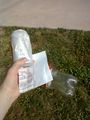
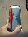
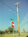
After getting off work and doing a few errands around Morton, I swung by with only my Active Geohasher flyer to show me where to go. I could see the location was right on top of a grey area amongst green, which I correctly surmised were rocks, but incorrectly surmised their purpose (I had though it might have been a landscaping thing). So, I didn't need a GPS to get me to the correct location. I pulled into the drive for the electrical relay station, the southerly of the two lots the location was in-between. That's when I found it was a culvert outlet. I just walked over, stood on the rocks, and took some pictures with my telephone. As culverts tend to gather garbage, I thought I'd do my geotrashing duty and pick up some bottles and cans - I didn't have a bag so that's the extent of what I was willing and able to clean up. That was it, and then I left!
Photos
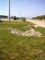
The spot
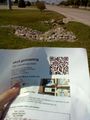
Proof of location (and date)

Proof of me
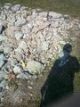
Shadow
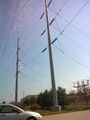
Powerlines to the south
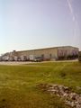
Butch's Pizza to the north
Some garbage
Sunbleached
Road


Achievements
Dvdllr earned the Land geohash achievement
|

Dvdllr earned the GeoTrash Geohash Achievement
|
Dvdllr earned the No Batteries Geohash Achievement
|