Difference between revisions of "2012-06-24 40 -74"
imported>Zubenelgenubi (Created page with "{{meetup graticule | lat=40 | lon=-74 | date=2012-06-24 }} <!-- edit as necessary --> __NOTOC__ == Participants == *Zubenelgenubi == Plans == The coordi...") |
imported>FippeBot m (Location) |
||
| (2 intermediate revisions by one other user not shown) | |||
| Line 11: | Line 11: | ||
== Plans == | == Plans == | ||
| − | The coordinates were on a roadside in South Brunswick Township. The plan was to aim for a [[Tron achievement|Tron achievement] by leaving home to the northeast and looping around to return from the south. | + | The coordinates were on a roadside in South Brunswick Township. The plan was to aim for a [[Tron achievement|Tron achievement]] by leaving home to the northeast and looping around to return from the south. |
== Expedition == | == Expedition == | ||
I overestimated my distance from the hashpoint after my first stop and had to backtrack after the second, blowing the Tron achievement. Much of the road had crash barriers for ditches on either side, making it hard to stop for long without climbing over the barriers. Eventually I honed in on a culvert near where the ditch joined a brook. | I overestimated my distance from the hashpoint after my first stop and had to backtrack after the second, blowing the Tron achievement. Much of the road had crash barriers for ditches on either side, making it hard to stop for long without climbing over the barriers. Eventually I honed in on a culvert near where the ditch joined a brook. | ||
| + | Instead of the Tron achievement, I picked up the [[Geotrash Geohash|Geotrash Geohash achievement]] by removing a beer can and half-full orange soda bottle from the roadside, but I did not attempt any of the litter in the ditch itself. | ||
== Photos == | == Photos == | ||
<gallery> | <gallery> | ||
| − | Image: | + | Image:20120624_bas_01.JPG|Seconds before this picture, my GPS read exactly the right coordinates in this location, then it changed. |
| − | Image: | + | Image:20120624_bas_02.JPG|Me with the almost-right coordinates |
| − | Image: | + | Image:20120624_bas_03.JPG|The culvert |
| + | Image:20120624_bas_04.JPG|Confluence of the mighty ditches | ||
| + | Image:20120624_bas_05.JPG|Sign | ||
| + | Image:20120624_bas_06.JPG|Emptying out the garbage for the [[Geotrash Geohash|Geotrash Geohash]] | ||
| + | Image:20120624_bas_07.JPG|Less than a mile from the geohash, this is <b>not</b> a construction site. | ||
| + | Image:20120624_bas_08.JPG|It's a site for training with construction/earthmoving equipment. | ||
| + | Image:20120624_bas_09.JPG|Basically, it's the biggest sandbox I've ever seen. | ||
</gallery> | </gallery> | ||
| Line 27: | Line 34: | ||
[[Category:Expeditions with photos]] | [[Category:Expeditions with photos]] | ||
[[Category:Coordinates reached]] | [[Category:Coordinates reached]] | ||
| + | {{location|US|NJ|MI}} | ||
Latest revision as of 04:42, 13 August 2019
| Sun 24 Jun 2012 in 40,-74: 40.3918425, -74.4812542 geohashing.info google osm bing/os kml crox |
Participants
Plans
The coordinates were on a roadside in South Brunswick Township. The plan was to aim for a Tron achievement by leaving home to the northeast and looping around to return from the south.
Expedition
I overestimated my distance from the hashpoint after my first stop and had to backtrack after the second, blowing the Tron achievement. Much of the road had crash barriers for ditches on either side, making it hard to stop for long without climbing over the barriers. Eventually I honed in on a culvert near where the ditch joined a brook.
Instead of the Tron achievement, I picked up the Geotrash Geohash achievement by removing a beer can and half-full orange soda bottle from the roadside, but I did not attempt any of the litter in the ditch itself.
Photos
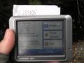
Seconds before this picture, my GPS read exactly the right coordinates in this location, then it changed.
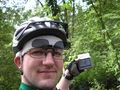
Me with the almost-right coordinates
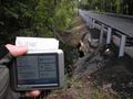
The culvert
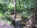
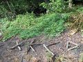
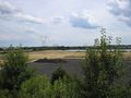
Confluence of the mighty ditches
Sign
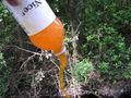
Emptying out the garbage for the Geotrash Geohash
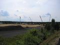
Less than a mile from the geohash, this is not a construction site.
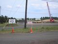
It's a site for training with construction/earthmoving equipment.
Basically, it's the biggest sandbox I've ever seen.


