Difference between revisions of "2012-06-30 52 13"
From Geohashing
imported>Kattapa (→Expedition) |
imported>FippeBot m (Location) |
||
| (9 intermediate revisions by 4 users not shown) | |||
| Line 1: | Line 1: | ||
| − | |||
| − | |||
| − | |||
| − | |||
| − | |||
| − | |||
| − | |||
| − | |||
| − | |||
| − | |||
{{meetup graticule | {{meetup graticule | ||
| lat=52 | | lat=52 | ||
| Line 15: | Line 5: | ||
}} | }} | ||
| − | |||
__NOTOC__ | __NOTOC__ | ||
== Location == | == Location == | ||
| Line 29: | Line 18: | ||
From Zeesen along some lakes and through some bits of forest to the geohash, then through another forest to Bestensee where I took the train home. | From Zeesen along some lakes and through some bits of forest to the geohash, then through another forest to Bestensee where I took the train home. | ||
| − | + | == Photos == | |
| − | |||
| − | |||
| − | == Photos == | ||
| − | |||
| − | |||
| − | |||
<gallery perrow="5"> | <gallery perrow="5"> | ||
| + | Image:2012_06_30_52_13_1.jpg|Zeesener See | ||
| + | Image:2012_06_30_52_13_2.jpg|On the road | ||
| + | Image:2012_06_30_52_13_3.jpg|Stupid Grin | ||
| + | Image:2012_06_30_52_13_4.jpg|Near the hash | ||
| + | Image:2012_06_30_52_13_5.jpg|On the way to Bestensee | ||
</gallery> | </gallery> | ||
== Achievements == | == Achievements == | ||
{{#vardefine:ribbonwidth|800px}} | {{#vardefine:ribbonwidth|800px}} | ||
| − | + | {{land geohash | |
| + | | latitude = 52 | ||
| + | | longitude = 13 | ||
| + | | date = 2012-06-30 | ||
| + | | name = [[User:Kattapa|Kattapa]] | ||
| + | }} | ||
| − | |||
| − | |||
| − | |||
| − | |||
| − | |||
| − | |||
| − | |||
| − | |||
| − | |||
| − | |||
| − | |||
[[Category:Expeditions]] | [[Category:Expeditions]] | ||
| − | |||
[[Category:Expeditions with photos]] | [[Category:Expeditions with photos]] | ||
| − | |||
| − | |||
| − | |||
| − | |||
| − | |||
[[Category:Coordinates reached]] | [[Category:Coordinates reached]] | ||
| − | + | {{location|DE|BB|LDS}} | |
| − | |||
| − | |||
| − | |||
| − | |||
| − | |||
| − | |||
| − | |||
| − | |||
| − | |||
Latest revision as of 04:50, 13 August 2019
| Sat 30 Jun 2012 in 52,13: 52.2420946, 13.6615016 geohashing.info google osm bing/os kml crox |
Location
In a Forest south of Königs Wusterhausen.
Participants
Expedition
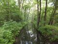
From Zeesen along some lakes and through some bits of forest to the geohash, then through another forest to Bestensee where I took the train home.
Photos
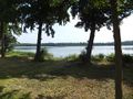
Zeesener See
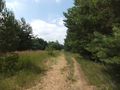
On the road
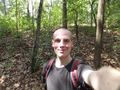
Stupid Grin
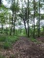
Near the hash
On the way to Bestensee


Achievements
Kattapa earned the Land geohash achievement
|