Difference between revisions of "2012-07-13 33 -116"
From Geohashing
imported>LucasBrown (→Achievements) |
imported>LucasBrown (→Photos) |
||
| Line 42: | Line 42: | ||
Image:2012-07-13_33_-116_12-46-16-072.jpg | Geohash Droid map at the hashpoint [http://www.openstreetmap.org/?lat=33.56629484&lon=-116.73697692&zoom=16&layers=B000FTF @33.5663,-116.7370] | Image:2012-07-13_33_-116_12-46-16-072.jpg | Geohash Droid map at the hashpoint [http://www.openstreetmap.org/?lat=33.56629484&lon=-116.73697692&zoom=16&layers=B000FTF @33.5663,-116.7370] | ||
| + | |||
| + | Image:2012-07-13_32_-117_12-48-51-181.jpg | The Hobbit achievement: barefoot, fed, and bearing a (key)ring [http://www.openstreetmap.org/?lat=33.56631688&lon=-116.73695723&zoom=16&layers=B000FTF @33.5663,-116.7370] | ||
</gallery> | </gallery> | ||
Revision as of 20:35, 13 July 2012
| Fri 13 Jul 2012 in 33,-116: 33.5662695, -116.7369868 geohashing.info google osm bing/os kml crox |
Location
Participants
Plans
Expedition
Tracklog
Photos
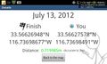
Geohash Droid details page at the hashpoint @33.5663,-116.7370
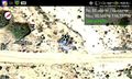
Geohash Droid map at the hashpoint @33.5663,-116.7370
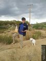
The Hobbit achievement: barefoot, fed, and bearing a (key)ring @33.5663,-116.7370


Achievements
LucasBrown earned the Hobbit Achievement
|