Difference between revisions of "2012-07-14 39 -105"
imported>Topbun (→Plans) |
imported>FippeBot m (Location) |
||
| (13 intermediate revisions by one other user not shown) | |||
| Line 1: | Line 1: | ||
| − | |||
<!-- If you did not specify these parameters in the template, please substitute appropriate values for IMAGE, LAT, LON, and DATE (YYYY-MM-DD format) | <!-- If you did not specify these parameters in the template, please substitute appropriate values for IMAGE, LAT, LON, and DATE (YYYY-MM-DD format) | ||
| Line 24: | Line 23: | ||
<!-- who attended: If you link to your wiki user name in this section, your expedition will be picked up by the various statistics generated for geohashing. You may use three tildes ~ as a shortcut to automatically insert the user signature of the account you are editing with. | <!-- who attended: If you link to your wiki user name in this section, your expedition will be picked up by the various statistics generated for geohashing. You may use three tildes ~ as a shortcut to automatically insert the user signature of the account you are editing with. | ||
--> | --> | ||
| + | [[User:Topbun|Topbun]] | ||
== Plans == | == Plans == | ||
| Line 31: | Line 31: | ||
== Expedition == | == Expedition == | ||
<!-- how it all turned out. your narrative goes here. --> | <!-- how it all turned out. your narrative goes here. --> | ||
| − | + | Getting to the hash was not overly complicated, I just had to do a few miles of riding on unmaintained forest service roads. The hash was located in the woods, about 500 feet from the road. I then rode to CR-80, which is the road which runs from Fraser to Nederland (FR 149). However, a sign near the beginning of the road informed me that a tunnel collapse now prevents travel to Nederland. I did some research later and discovered that Needle's Eye Tunnel has been caved in since 1990. This had happened in the past as well, but in a 1990 attempt to reopen the tunnel, a worker was killed and the efforts were stopped. Still, a cool road and spot/successful hash. | |
| − | + | [[Image:2012-07-14_39_-105_road.jpeg|240 px|thumb|right|The road is smooth and scenic here, 500 ft. from the hash.]] | |
| − | |||
== Photos == | == Photos == | ||
| Line 40: | Line 39: | ||
--> | --> | ||
<gallery perrow="5"> | <gallery perrow="5"> | ||
| + | Image:2012-07-14_39_-105_forest.jpeg | Walking through the forest to the hash point. | ||
| + | Image:2012-07-14_39_-105_hash_point.jpeg | The hash point in a grove of trees. | ||
| + | Image:File-2012-07-14_39_-105_fallen_tree.jpeg | A fallen tree near the hash. | ||
| + | Image:2012-07-14_39_-105_me.jpeg | Obligatory head shot. | ||
| + | Image:File-2012-07-14_39_-105_clearing.jpeg | A clearing next to the hash. | ||
| + | Image:2012-07-14_39_-105_bones.JPG | Some bones near the hash. | ||
| + | Image:2012-07-14_39_-105_GPS_info1.jpeg | GPS information/proof. | ||
</gallery> | </gallery> | ||
| Line 45: | Line 51: | ||
{{#vardefine:ribbonwidth|800px}} | {{#vardefine:ribbonwidth|800px}} | ||
<!-- Add any achievement ribbons you earned below, or remove this section --> | <!-- Add any achievement ribbons you earned below, or remove this section --> | ||
| + | {{consecutive geohash | ||
| + | | count = 2 | ||
| + | | latitude = 39 | ||
| + | | longitude = -105 | ||
| + | | date = 2012-07-13 | ||
| + | | name = Topbun | ||
| + | }} | ||
<!-- =============== USEFUL CATEGORIES FOLLOW ================ | <!-- =============== USEFUL CATEGORIES FOLLOW ================ | ||
Delete the next line ONLY if you have chosen the appropriate categories below. If you are unsure, don't worry. People will read your report and help you with the classification. --> | Delete the next line ONLY if you have chosen the appropriate categories below. If you are unsure, don't worry. People will read your report and help you with the classification. --> | ||
| − | + | ||
<!-- Potential categories. Please include all the ones appropriate to your expedition --> | <!-- Potential categories. Please include all the ones appropriate to your expedition --> | ||
| Line 56: | Line 69: | ||
--> | --> | ||
| − | + | ||
[[Category:Expeditions]] | [[Category:Expeditions]] | ||
| − | + | ||
[[Category:Expeditions with photos]] | [[Category:Expeditions with photos]] | ||
| − | + | ||
| − | + | ||
| − | |||
| − | |||
| − | |||
[[Category:Coordinates reached]] | [[Category:Coordinates reached]] | ||
| − | + | {{location|US|CO|GR}} | |
| − | |||
| − | |||
| − | |||
| − | |||
| − | |||
| − | |||
| − | |||
| − | |||
| − | |||
| − | |||
| − | |||
| − | |||
| − | |||
| − | |||
| − | |||
| − | |||
| − | |||
Latest revision as of 04:59, 6 August 2019
| Sat 14 Jul 2012 in 39,-105: 39.9940494, -105.7526735 geohashing.info google osm bing/os kml crox |
Location
A few miles NE of Fraser, CO, in the Arapaho National Forest.
Participants
Plans
I'm heading to Boulder today, so I did some map research and realized that I could get this hash on the way by taking an old mountain pass from Fraser to Nederland. Hopefully this will turn out to be a much easier hash than the last two days, as it appears to be less than 500 feet from the road it's near.
Expedition
Getting to the hash was not overly complicated, I just had to do a few miles of riding on unmaintained forest service roads. The hash was located in the woods, about 500 feet from the road. I then rode to CR-80, which is the road which runs from Fraser to Nederland (FR 149). However, a sign near the beginning of the road informed me that a tunnel collapse now prevents travel to Nederland. I did some research later and discovered that Needle's Eye Tunnel has been caved in since 1990. This had happened in the past as well, but in a 1990 attempt to reopen the tunnel, a worker was killed and the efforts were stopped. Still, a cool road and spot/successful hash.

Photos
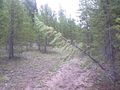
Walking through the forest to the hash point.
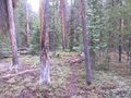
The hash point in a grove of trees.
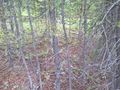
A fallen tree near the hash.
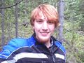
Obligatory head shot.

A clearing next to the hash.
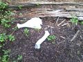
Some bones near the hash.
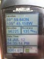
GPS information/proof.


Achievements
Topbun earned the Consecutive geohash achievement
|