Difference between revisions of "2012-07-14 51 5"
imported>Eupeodes (→Expedition) |
imported>FippeBot m (Location) |
||
| (17 intermediate revisions by 2 users not shown) | |||
| Line 1: | Line 1: | ||
| − | |||
<!-- If you did not specify these parameters in the template, please substitute appropriate values for IMAGE, LAT, LON, and DATE (YYYY-MM-DD format) | <!-- If you did not specify these parameters in the template, please substitute appropriate values for IMAGE, LAT, LON, and DATE (YYYY-MM-DD format) | ||
| Line 49: | Line 48: | ||
</gallery> | </gallery> | ||
| − | So it was a [[Midnight_Geohash|Midnight]] [[Birthday_Geohash|birthday]] [[Tron_achievement|tron]] [[Walk_geohash|walk]] geohash. Since I don't have a golf ball and did not manage to find one it does not qualify for [[ | + | So it was a [[Midnight_Geohash|Midnight]] [[Birthday_Geohash|birthday]] [[Tron_achievement|tron]] [[Walk_geohash|walk]] [[Land_geohash|land]] geohash. Since I don't have a golf ball and did not manage to find one it does not qualify for [[Golf Geohash]]. |
== Tracklog == | == Tracklog == | ||
<!-- if your GPS device keeps a log, you may post a link here --> | <!-- if your GPS device keeps a log, you may post a link here --> | ||
| + | GPS was not always very accurate, some moving back and forth recorded while I just walked on. So it is a tron but the gps fails a bit. | ||
| − | == | + | [https://maps.google.nl/maps?q=http:%2F%2Fgeohashing.eupeodes.nl%2Ftracks%2F20120714.kml&hl=nl&sll=51.967677,5.650564&sspn=0.007972,0.013797&t=w&z=12 Track of Eupeodes] |
| − | |||
| − | |||
| − | |||
| − | |||
| − | |||
== Achievements == | == Achievements == | ||
{{#vardefine:ribbonwidth|800px}} | {{#vardefine:ribbonwidth|800px}} | ||
<!-- Add any achievement ribbons you earned below, or remove this section --> | <!-- Add any achievement ribbons you earned below, or remove this section --> | ||
| + | {{Combo | ||
| + | | latitude = 51 | ||
| + | | longitude = 5 | ||
| + | | date = 2012-07-14 | ||
| + | | comboname = [[Midnight_Geohash|Midnight]] [[Birthday_Geohash|birthday]] [[Tron_achievement|tron]] [[Walk_geohash|walk]] [[Land_geohash|land]] geohash | ||
| + | | action = walking to the hash and reaching it at midnight at the start of his birthday and making sure not to cross his [https://maps.google.nl/maps?q=http:%2F%2Fgeohashing.eupeodes.nl%2Ftracks%2F20120714.kml&hl=nl&sll=51.967677,5.650564&sspn=0.007972,0.013797&t=w&z=12 own tracks] | ||
| + | | name = [[User:Eupeodes|Eupeodes]] | ||
| + | | icon4 = Walk.PNG | ||
| + | | icon3 = Lightcycle.png | ||
| + | | icon1 = Midnightgeohash.png | ||
| + | | icon2 = Birthday.PNG | ||
| + | | icon5 = Landgeohash.png | ||
| + | | cat4 = Walk_geohash_achievement | ||
| + | | cat3 = Tron_achievement | ||
| + | | cat1 = Midnight geohash achievement | ||
| + | | cat2 = Birthday geohash achievement | ||
| + | | cat5 = Land geohash achievement | ||
| + | }} | ||
| + | {{Radio Yerevan | ||
| + | | achievement = [[Golf Geohash]] | ||
| + | | detail = he did not have a golf ball to drop on the hashpoint | ||
| + | | date = 2012-07-14 | ||
| + | | latitude = 51 | ||
| + | | longitude = 5 | ||
| + | | user = [[User:Eupeodes|Eupeodes]] | ||
| + | }} | ||
| − | |||
| − | |||
| − | |||
| − | |||
| − | |||
| − | |||
| − | |||
| − | |||
| − | |||
| − | |||
| − | |||
[[Category:Expeditions]] | [[Category:Expeditions]] | ||
| − | |||
[[Category:Expeditions with photos]] | [[Category:Expeditions with photos]] | ||
| − | |||
| − | |||
| − | |||
| − | |||
| − | |||
[[Category:Coordinates reached]] | [[Category:Coordinates reached]] | ||
| − | + | [[Category:Eupeodes]] | |
| − | + | {{location|NL|GE}} | |
| − | |||
| − | [[Category: | ||
| − | |||
| − | |||
| − | |||
| − | |||
| − | |||
| − | |||
| − | |||
| − | |||
| − | |||
| − | |||
| − | |||
| − | |||
| − | |||
| − | |||
Latest revision as of 05:02, 13 August 2019
| Sat 14 Jul 2012 in 51,5: 51.9940494, 5.7526735 geohashing.info google osm bing/os kml crox |
Location
On a golf course near Heelsum
Participants
Plans
Walk there, be there at midnight at the start of birthday, take the last bus back to Wageningen and walk home. All in a perfect tron.
Expedition
At around 21:30 I left home, first I had to take some nice pictures of the sun.


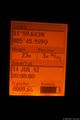
Now I could go, I walked trough Wageningen which was not that exciting. When I left Wageningen it became interesting. In the forest it was very dark and the GPS failed quite some time. It was just a straight road so no real difference for the track. After passing trough Heelsum I got on a road past the golf course. When I was at ~500 meters from the hash I left the road and walked onto the green, no signs that forbid access, only a sort of fence, more a line at a few centimeters above the ground so I ignored it. Now I walked on the course and at 5 minutes before midnight I was at 80 meters of the hash. Hash on the middel of the green, so walked there, waited until it was exactly midnight and took a picture of the gps. I omitted the stupid grin because it was dark so I had to use flash for it. I did not want to use it because I was in line of sight from several houses. Now I walked to the busstop. On the way to the busstop I found some signs telling that only players with accesscard were allowed on the course. At the busstop I took some more pictures including a grin. From the busstop I took the last bus of the day to Wageningen. From the busstation there was no connecting bus available but luckily the busdriver was willing to drop me of close to my home (much closer than the closest busstop). Now I could walk the last part completing the Tron.
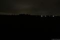
It was dark
Right place and moment

At the busstop
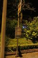
The busstop
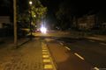
The bus is comming

Yes, it is my birthday


So it was a Midnight birthday tron walk land geohash. Since I don't have a golf ball and did not manage to find one it does not qualify for Golf Geohash.
Tracklog
GPS was not always very accurate, some moving back and forth recorded while I just walked on. So it is a tron but the gps fails a bit.
Achievements
Eupeodes earned the Midnight birthday tron walk land geohash Achievement
|
Is it true that Eupeodes earned the Golf Geohash?
|