Difference between revisions of "2012-07-15 37 -121"
imported>Chandru (Created page with "{{subst:meetup graticule |lat = 37 |lon = -121 |date = 2012-07-15 }} == Location == The Lexington Reservoir, off of Old Santa Cruz Highway. == Participants == [[User:Chandru...") |
m |
||
| (3 intermediate revisions by 3 users not shown) | |||
| Line 1: | Line 1: | ||
| − | {{ | + | {{meetup graticule |
| − | + | | lat=37 | |
| − | + | | lon=-121 | |
| − | + | | date=2012-07-15 | |
| − | + | }} | |
| − | |||
| − | |||
| − | |||
| − | |||
| − | |||
| − | |||
| − | |||
| − | |||
| − | |||
== Location == | == Location == | ||
| Line 21: | Line 12: | ||
== Participants == | == Participants == | ||
| − | [[User:Chandru|Chandru]] | + | *[[User:Chandru|Chandru]] |
== Expedition == | == Expedition == | ||
| − | As this is close to my house, Chandru plans to bike there sometime in the afternoon. | + | As this is close to my house, Chandru plans to bike there sometime in the afternoon. (''Probably should have put this in "Plans." Still new to the site.'') |
| + | |||
| + | Anyway, so after I found out that the hashpoint was <10 miles (9.9 to be precise) from my home, I had to go. I set out biking down Camden Avenue in San Jose, then it turned into San Tomas Expressway in Campbell. I entered the Los Gatos Creek trail from that road. | ||
| + | |||
| + | <gallery perrow="4"> | ||
| + | Image:lgcreekatsantomas71512.jpg|LG Creek Trail at San Tomas. You can see bikers, the creek, CA-17 (and the sign for the junction with CA-85), and the mountains where the geohash is. | ||
| + | Image:dogpark71512.jpg|The dog park off of LG Creek Trail. Accessible via the trail or by the parking lot on Sunnyoaks Avenue. | ||
| + | Image:vasona71512.jpg|Vasona Lake, easily accessible by the trail. Parking is off of Blossom Hill Road. Apologies for thumb on lens. | ||
| + | Image:bridgeover17_71512.jpg|Where the LG Creek Trail crosses CA-17, between CA-9 (LG-Saratoga Road) and Santa Cruz Avenue. Looks to be an accident, all I saw was a Fiesta facing the wrong way. There were a lot of rubberneckers, especially on the Mines Road bridge (bridge viewable in the foreground). | ||
| + | Image:sun71512.jpg|Some paintings on the bridge done by the local elementary school. | ||
| + | Image:firststeephillofthetrail71512.jpg|At this part of the trail, it became very steep and the gravel felt like sand. Time for me to walk my bike! | ||
| + | Image:hillside71512.jpg|This part shows where the trail leaves urban Los Gatos and goes towards rural Redwood Estates. | ||
| + | Image:aqueduct71512.jpg|Aqueduct. Carries hashwater (as in, water from the hashpoint) to homes across the Silicon Valley. | ||
| + | Image:randomstaircase71512.jpg|A random staircase that seems to lead to nowhere. Hadn't noticed it until today. | ||
| + | Image:almabridgeatlgcreektrail71512.jpg|The end of the trail! Lexington Reservoir, at the intersection of LG Creek Trail and Alma Bridge Road. | ||
| + | </gallery> | ||
| + | |||
| + | Here I reached the Lexington Reservoir. The water has submerged two ghost[http://en.wikipedia.org/wiki/Lexington,_California] towns[http://en.wikipedia.org/wiki/Alma,_California] and the old routing for CA-17[http://en.wikipedia.org/wiki/CA_17#History]. | ||
| + | |||
| + | After I exited the trail, I turned right on Alma Bridge Road. It ended on Highway 17. There was a small trail. I took that as I didn't want to go against the traffic on the major throughfare between Santa Cruz and SJ. It led to Old Santa Cruz Highway, then there was another trail that branched off of that road. | ||
| + | |||
| + | <gallery perrow="4"> | ||
| + | Image:almabridgeat17_71512.jpg|Alma Bridge at CA-17, with a view of the trail that follows the road. | ||
| + | Image:trail71512.jpg|The trail. It said "authorized vehicles only." I say, "what kind of vehicles can go on this narrow trail?" It barely fits my bike. | ||
| + | Image:nowading71512.jpg|I just realized that I completely ignored this sign. I went wading to attempt to reach the hashpoint. | ||
| + | Image:traffic71512.jpg|Glad I wasn't driving! I zoomed in heavily which was probably what made this picture look kind of weird and oil painting-like. In the foreground is Old Santa Cruz Highway, in the background is CA-17 (Santa Cruz Highway). | ||
| + | Image:notrespassing71512.jpg|Before you ask, I kept left. | ||
| + | </gallery> | ||
| + | |||
| + | After going down these tiny, poorly maintained trails (my bike, meant for use in the city mainly, was about to kill me), I saw a small trail that seemed to lead to lake's edge. I locked my bike to a random power line and went down the very steep grade. | ||
| + | |||
| + | <gallery perrow="4"> | ||
| + | Image:bike71512.jpg | ||
| + | Image:plant711512.jpg|I saw these plants close to the lake. Again, as in my previous geohash, I have no idea what they are. | ||
| + | </gallery> | ||
| + | |||
| + | When I reached the lake, I had a slight problem. I was expecting the lake to be reasonably easy to wade into. Nope. | ||
| + | |||
| + | <gallery perrow="4"> | ||
| + | Image:insidethereservoir71512.jpg|How did they build two towns and a freeway over this? | ||
| + | </gallery> | ||
| + | |||
| + | The GPS still said I had 30 meters to go. Impossible :( | ||
| + | |||
| + | I did manage to leave my temporary mark on the place... | ||
| + | |||
| + | <gallery perrow="4"> | ||
| + | Image:reservoiraftermyattemptathashing71512.jpg|Now I can see why they say no wading. Though it's probably to make sure you don't get stuck in the quicksand-like material under the reservoir. | ||
| + | </gallery> | ||
| + | |||
| + | And also in a good way! I got some Geotrashing done. | ||
| + | |||
| + | <gallery perrow="4"> | ||
| + | Image:geotrashing71512.jpg|Can you say irony? | ||
| + | </gallery> | ||
| + | |||
| + | I got some nice shots of the area though. | ||
| + | |||
| + | <gallery perrow="4"> | ||
| + | Image:panorama71512.jpg|I'm not sure, but I think I was still in the lake when I took these. | ||
| + | Image:panorama2_71512.jpg | ||
| + | Image:landpanorama71512.jpg|This one was on land | ||
| + | Image:obligatory71512.jpg|Obligatory. Don't know why I still had my bike helmet on. | ||
| + | </gallery> | ||
| + | |||
| + | While going back, I elected to avoid some of the trails. The fastest way to do this was to take Old Santa Cruz Highway and actually bike down 17 for a bit. It wasn't that bad though, the shoulder was wide and the freeway had ended (essentially it was a four-lane expressway at this point). Also traffic wasn't moving too fast. | ||
| + | |||
| + | <gallery perrow="4"> | ||
| + | Image:trafficon17_71512.jpg| | ||
| + | </gallery> | ||
| + | |||
| + | |||
| + | == Achievements == | ||
| + | {{mnb geohash | ||
| + | | latitude = 37 | ||
| + | | longitude = -121 | ||
| + | | date = 2012-07-15 | ||
| + | | name = Chandru | ||
| + | | image = obligatory71512.jpg | ||
| + | }} | ||
| + | |||
| + | {{Geotrash | ||
| + | | latitude = 37 | ||
| + | | longitude = -121 | ||
| + | | date = 2012-07-15 | ||
| + | | name = Chandru | ||
| + | | image = geotrashing71512.jpg | ||
| + | }} | ||
| + | |||
| + | [[Category:Expeditions]] | ||
| + | [[Category:Expeditions with photos]] | ||
| + | [[Category:Coordinates not reached]] | ||
| + | [[Category:Not reached - Mother Nature]] | ||
| + | {{location|US|CA|SL}} | ||
Revision as of 10:06, 22 September 2021
| Sun 15 Jul 2012 in 37,-121: 37.1840800, -121.9890418 geohashing.info google osm bing/os kml crox |
Location
The Lexington Reservoir, off of Old Santa Cruz Highway.
Participants
Expedition
As this is close to my house, Chandru plans to bike there sometime in the afternoon. (Probably should have put this in "Plans." Still new to the site.)
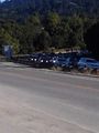
Anyway, so after I found out that the hashpoint was <10 miles (9.9 to be precise) from my home, I had to go. I set out biking down Camden Avenue in San Jose, then it turned into San Tomas Expressway in Campbell. I entered the Los Gatos Creek trail from that road.
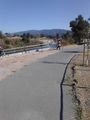
LG Creek Trail at San Tomas. You can see bikers, the creek, CA-17 (and the sign for the junction with CA-85), and the mountains where the geohash is.
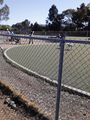
The dog park off of LG Creek Trail. Accessible via the trail or by the parking lot on Sunnyoaks Avenue.
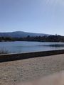
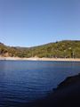
Vasona Lake, easily accessible by the trail. Parking is off of Blossom Hill Road. Apologies for thumb on lens.
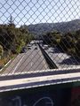
Where the LG Creek Trail crosses CA-17, between CA-9 (LG-Saratoga Road) and Santa Cruz Avenue. Looks to be an accident, all I saw was a Fiesta facing the wrong way. There were a lot of rubberneckers, especially on the Mines Road bridge (bridge viewable in the foreground).

Some paintings on the bridge done by the local elementary school.
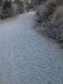
At this part of the trail, it became very steep and the gravel felt like sand. Time for me to walk my bike!
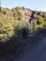
This part shows where the trail leaves urban Los Gatos and goes towards rural Redwood Estates.
Aqueduct. Carries hashwater (as in, water from the hashpoint) to homes across the Silicon Valley.
A random staircase that seems to lead to nowhere. Hadn't noticed it until today.
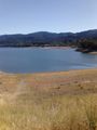
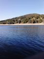
The end of the trail! Lexington Reservoir, at the intersection of LG Creek Trail and Alma Bridge Road.


Here I reached the Lexington Reservoir. The water has submerged two ghost[1] towns[2] and the old routing for CA-17[3].
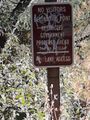
After I exited the trail, I turned right on Alma Bridge Road. It ended on Highway 17. There was a small trail. I took that as I didn't want to go against the traffic on the major throughfare between Santa Cruz and SJ. It led to Old Santa Cruz Highway, then there was another trail that branched off of that road.
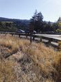
Alma Bridge at CA-17, with a view of the trail that follows the road.
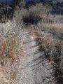
The trail. It said "authorized vehicles only." I say, "what kind of vehicles can go on this narrow trail?" It barely fits my bike.
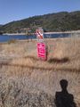
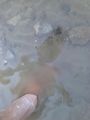
I just realized that I completely ignored this sign. I went wading to attempt to reach the hashpoint.
Glad I wasn't driving! I zoomed in heavily which was probably what made this picture look kind of weird and oil painting-like. In the foreground is Old Santa Cruz Highway, in the background is CA-17 (Santa Cruz Highway).
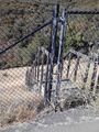
Before you ask, I kept left.


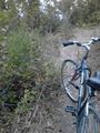
After going down these tiny, poorly maintained trails (my bike, meant for use in the city mainly, was about to kill me), I saw a small trail that seemed to lead to lake's edge. I locked my bike to a random power line and went down the very steep grade.
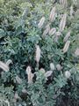
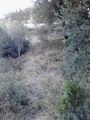
I saw these plants close to the lake. Again, as in my previous geohash, I have no idea what they are.


When I reached the lake, I had a slight problem. I was expecting the lake to be reasonably easy to wade into. Nope.
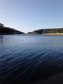
How did they build two towns and a freeway over this?

The GPS still said I had 30 meters to go. Impossible :(
I did manage to leave my temporary mark on the place...
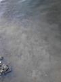
Now I can see why they say no wading. Though it's probably to make sure you don't get stuck in the quicksand-like material under the reservoir.

And also in a good way! I got some Geotrashing done.
Can you say irony?

I got some nice shots of the area though.
I'm not sure, but I think I was still in the lake when I took these.
This one was on land

Obligatory. Don't know why I still had my bike helmet on.


While going back, I elected to avoid some of the trails. The fastest way to do this was to take Old Santa Cruz Highway and actually bike down 17 for a bit. It wasn't that bad though, the shoulder was wide and the freeway had ended (essentially it was a four-lane expressway at this point). Also traffic wasn't moving too fast.

Achievements
Chandru earned the GeoTrash Geohash Achievement
|