Difference between revisions of "2012-07-20 39 -74"
From Geohashing
imported>Mischief (→Photos) |
imported>FippeBot m (Location) |
||
| (8 intermediate revisions by 2 users not shown) | |||
| Line 1: | Line 1: | ||
| − | |||
| − | |||
| − | |||
| − | |||
| − | |||
| − | |||
| − | |||
| − | |||
| − | |||
| − | |||
{{meetup graticule | {{meetup graticule | ||
| lat=39 | | lat=39 | ||
| Line 15: | Line 5: | ||
}} | }} | ||
| − | + | ||
__NOTOC__ | __NOTOC__ | ||
== Location == | == Location == | ||
| − | + | ||
| + | A small wooded development in Waterford, NJ. | ||
== Participants == | == Participants == | ||
| − | |||
| − | |||
| − | + | * [[User: Mischief | Mischief]] | |
| − | |||
== Expedition == | == Expedition == | ||
<!-- how it all turned out. your narrative goes here. --> | <!-- how it all turned out. your narrative goes here. --> | ||
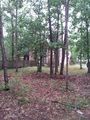
| + | Overall not too remarkable. It was a nice cool day after a long heat wave in NJ and a thunderstorm had blown in. Exhausted from last night's midnight showing of Dark Knight Rises I didn't want to try anything fancy. After an hour drive I arrived in a heavily wooded development and managed to get pretty close to the hash using side roads. After quickly peeing in a bush and being spot by some local inhabitants who decided to go out for a walk I disappeared into the woods to find the hash. I found it easily and snapped a picture; noticing some trash I tidied up a bit, enjoyed a victory protein bar and headed home. | ||
| − | == | + | == Photos == |
| − | |||
| − | |||
| − | |||
| − | |||
| − | |||
<gallery perrow="5"> | <gallery perrow="5"> | ||
Image:2012-07-20_39_-74_15-08-42-386.jpg | [http://www.openstreetmap.org/?lat=39.75439410&lon=-74.83261254&zoom=16&layers=B000FTF @39.7544,-74.8326] | Image:2012-07-20_39_-74_15-08-42-386.jpg | [http://www.openstreetmap.org/?lat=39.75439410&lon=-74.83261254&zoom=16&layers=B000FTF @39.7544,-74.8326] | ||
| − | |||
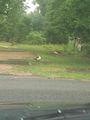
Image:2012_07_20_Duck.jpg | Image:2012_07_20_Duck.jpg | ||
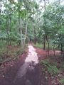
Image:2012_07_20_Trail.jpg | Image:2012_07_20_Trail.jpg | ||
| Line 49: | Line 32: | ||
== Achievements == | == Achievements == | ||
{{#vardefine:ribbonwidth|800px}} | {{#vardefine:ribbonwidth|800px}} | ||
| − | |||
| + | *Land Geohash | ||
| + | {{Geotrash | ||
| + | | latitude = 39 | ||
| + | | longitude = -74 | ||
| + | | date = 2012-07-20 | ||
| + | | name = [[User:Mischief | Mischief]] | ||
| + | | image = 2012_07_20_Geotrash.jpg | ||
| + | }} | ||
| − | |||
| − | |||
| − | |||
| − | |||
| − | |||
| − | |||
| − | |||
| − | |||
| − | |||
[[Category:Expeditions]] | [[Category:Expeditions]] | ||
| − | |||
[[Category:Expeditions with photos]] | [[Category:Expeditions with photos]] | ||
| − | |||
| − | |||
| − | |||
| − | |||
| − | |||
[[Category:Coordinates reached]] | [[Category:Coordinates reached]] | ||
| − | + | {{location|US|NJ|CM}} | |
| − | |||
| − | |||
| − | |||
| − | |||
| − | |||
| − | |||
| − | |||
| − | |||
| − | |||
| − | |||
| − | |||
| − | |||
| − | |||
| − | |||
| − | |||
| − | |||
| − | |||
Latest revision as of 05:07, 13 August 2019
| Fri 20 Jul 2012 in 39,-74: 39.7543930, -74.8327113 geohashing.info google osm bing/os kml crox |
Location
A small wooded development in Waterford, NJ.
Participants
Expedition
Overall not too remarkable. It was a nice cool day after a long heat wave in NJ and a thunderstorm had blown in. Exhausted from last night's midnight showing of Dark Knight Rises I didn't want to try anything fancy. After an hour drive I arrived in a heavily wooded development and managed to get pretty close to the hash using side roads. After quickly peeing in a bush and being spot by some local inhabitants who decided to go out for a walk I disappeared into the woods to find the hash. I found it easily and snapped a picture; noticing some trash I tidied up a bit, enjoyed a victory protein bar and headed home.
Photos
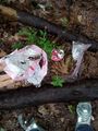
Geotrash at the Geohash


Achievements
- Land Geohash
Mischief earned the GeoTrash Geohash Achievement
|