Difference between revisions of "2012-07-21 33 -116"
imported>LucasBrown |
imported>FippeBot m (Location) |
||
| (14 intermediate revisions by 2 users not shown) | |||
| Line 1: | Line 1: | ||
| − | |||
| − | |||
| − | |||
| − | |||
| − | |||
| − | |||
| − | |||
| − | |||
| − | |||
{{meetup graticule | {{meetup graticule | ||
| lat=33 | | lat=33 | ||
| Line 14: | Line 5: | ||
}} | }} | ||
| − | |||
__NOTOC__ | __NOTOC__ | ||
== Location == | == Location == | ||
| − | + | Just off an unnamed dirt road that splits off of County Road S2 in the Anza-Borrego Desert amid a field of jumping cholla and various forms of yucca | |
== Participants == | == Participants == | ||
| − | + | * [[User:LucasBrown|LucasBrown]] | |
| − | |||
| − | |||
| − | |||
| − | |||
== Expedition == | == Expedition == | ||
| − | + | The hasher drove from his home in Poway out along SR67 to SR78 to Butterfield Stage Road | |
| + | (County Road S2). Traveling south along this road, an unpaved dirt road eventually splits | ||
| + | off to the left. After a brief drive down this road, the hasher parked the vehicle and | ||
| + | commenced walking west-southwest towards the hashpoint, about 300 meters away. | ||
| − | + | Accompanying the hasher were two small canines who often found it advantageous to scamper | |
| − | + | ahead of the hasher a few dozen feet to some shade to mitigate the effects of the 100+°F | |
| + | heat. They failed, however, to distinguish between jumping cholla cactus and benign flora | ||
| + | and consequently picked up several spiky burrs in their fur. | ||
== Photos == | == Photos == | ||
| − | |||
| − | |||
| − | |||
<gallery perrow="5"> | <gallery perrow="5"> | ||
| − | |||
| − | |||
Image:2012-07-21_33_-116_18-04-54-169.jpg | Geohash droid screenshot at the hashpoint | Image:2012-07-21_33_-116_18-04-54-169.jpg | Geohash droid screenshot at the hashpoint | ||
| Line 45: | Line 31: | ||
Image:2012-07-21_33_-116_18-07-01-393.jpg | A critter-hole near the hashpoint. In some places the ground was so dense (porous?) with them that the soil caved in underfoot. | Image:2012-07-21_33_-116_18-07-01-393.jpg | A critter-hole near the hashpoint. In some places the ground was so dense (porous?) with them that the soil caved in underfoot. | ||
| + | |||
| + | Image:2012-07-21_33_-116_18-10-12-805.jpg | Rubber chickens at the hashpoint | ||
| + | |||
| + | Image:2012-07-21_33_-116_18-11-54-756.jpg | Geotrash Geohash: Refuse found near the hashpoint. Six-inch rubber chicken for scale. | ||
| + | |||
| + | Image:2012-07-21_33_-116_18-13-41-606.jpg | Anthills near the hashpoint | ||
| + | |||
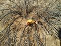
| + | Image:2012-07-21_33_-116_18-14-09-611.jpg | Local flora | ||
| + | |||
| + | Image:2012-07-21_33_-116_18-14-46-418.jpg | Local flora | ||
</gallery> | </gallery> | ||
== Achievements == | == Achievements == | ||
{{#vardefine:ribbonwidth|800px}} | {{#vardefine:ribbonwidth|800px}} | ||
| − | + | {{Geotrash | latitude = 33 | longitude = -116 | date = 2012-07-21 | name = LucasBrown}} | |
| − | + | {{Land geohash | latitude = 33 | longitude = -116 | date = 2012-07-21 | name = LucasBrown}} | |
| − | |||
| − | |||
| − | |||
| − | |||
| − | |||
| − | |||
| − | |||
| − | |||
| − | |||
[[Category:Expeditions]] | [[Category:Expeditions]] | ||
| − | |||
[[Category:Expeditions with photos]] | [[Category:Expeditions with photos]] | ||
| − | |||
| − | |||
| − | |||
| − | |||
| − | |||
[[Category:Coordinates reached]] | [[Category:Coordinates reached]] | ||
| − | + | {{location|US|CA|SD}} | |
| − | |||
| − | |||
| − | |||
| − | |||
| − | |||
| − | |||
| − | |||
| − | |||
| − | |||
| − | |||
| − | |||
| − | |||
| − | |||
| − | |||
| − | |||
| − | |||
| − | |||
Latest revision as of 05:08, 13 August 2019
| Sat 21 Jul 2012 in 33,-116: 33.0420860, -116.4041931 geohashing.info google osm bing/os kml crox |
Location
Just off an unnamed dirt road that splits off of County Road S2 in the Anza-Borrego Desert amid a field of jumping cholla and various forms of yucca
Participants
Expedition
The hasher drove from his home in Poway out along SR67 to SR78 to Butterfield Stage Road (County Road S2). Traveling south along this road, an unpaved dirt road eventually splits off to the left. After a brief drive down this road, the hasher parked the vehicle and commenced walking west-southwest towards the hashpoint, about 300 meters away.
Accompanying the hasher were two small canines who often found it advantageous to scamper ahead of the hasher a few dozen feet to some shade to mitigate the effects of the 100+°F heat. They failed, however, to distinguish between jumping cholla cactus and benign flora and consequently picked up several spiky burrs in their fur.
Photos
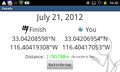
Geohash droid screenshot at the hashpoint
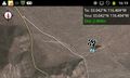
Geohash Droid map at the hashpoint
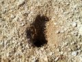
A critter-hole near the hashpoint. In some places the ground was so dense (porous?) with them that the soil caved in underfoot.
Rubber chickens at the hashpoint
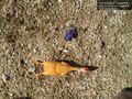
Geotrash Geohash: Refuse found near the hashpoint. Six-inch rubber chicken for scale.
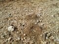
Anthills near the hashpoint
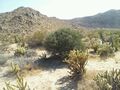
Local flora
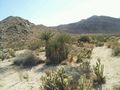
Local flora


Achievements
LucasBrown earned the GeoTrash Geohash Achievement
|
LucasBrown earned the Land geohash achievement
|