Difference between revisions of "2012-07-21 49 -122"
imported>Rhonda m (oops, forgot photo captions) |
m (More specific location) |
||
| (One intermediate revision by one other user not shown) | |||
| Line 42: | Line 42: | ||
[[Category:Expeditions with photos]] | [[Category:Expeditions with photos]] | ||
[[Category:Coordinates reached]] | [[Category:Coordinates reached]] | ||
| + | {{location|CA|BC|FV}} | ||
Latest revision as of 23:57, 9 August 2020
| Sat 21 Jul 2012 in 49,-122: 49.0420860, -122.4041931 geohashing.info google osm bing/os kml crox |
Participants
Location
Just off Ross Road, a few blocks west of Abbotsford airport
Plans
I'm going to be in Aldergrove anyway this afternoon so I'm going to swing by and see what's there. Probably between 3-4PM.
Expedition
After completing my plans in Aldergrove, I drove to the hashpoint, hoping it wouldn't be a farmer's field or something inaccessible.
Fortunately, there was plenty of room to pull off the road right by an open gate leading into a small grassy field where the hashpoint was. I didn't drive into the field although there were very obvious muddy tire tracks leading out, so clearly there were people who did drive in this field.
Walked into the field, looked around, looked at my GPS, took photos. I didn't leave any marker, largely because there didn't seem to be much in the way of debris at the hashpoint. It really was just a grassy field, almost a lawn.
Photos

Door's open, come on in

At the hashpoint there is ... grass.
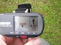
But this is definitely the right place.


