Difference between revisions of "2012-07-22 -31 -64"
imported>Onicofago (→Plans) |
m (per Renaming Proposal) |
||
| (9 intermediate revisions by 2 users not shown) | |||
| Line 1: | Line 1: | ||
| − | |||
<!-- If you did not specify these parameters in the template, please substitute appropriate values for IMAGE, LAT, LON, and DATE (YYYY-MM-DD format) | <!-- If you did not specify these parameters in the template, please substitute appropriate values for IMAGE, LAT, LON, and DATE (YYYY-MM-DD format) | ||
| Line 27: | Line 26: | ||
== Expedition == | == Expedition == | ||
| − | + | Having a gargantuan breakfast in bed was a very good way to start a birthday, I would say. Second to that, peeping at the iPhone GeoHash app and seeing that today's hash was an achievable one, was pure and unadulterated joy. | |
| + | |||
| + | SO and me hopped onto the car and swiftly rushed to the road, in a very pleasant and sunny Sunday. Lots of tourists had the very same idea, though. In the end, we got to the point and back, drinking mate in the car and chatting all along. | ||
| + | |||
| + | The hash was located in a high spot, approximately 200 meters over a nearby hill west of the road. I was thrilled, because I got three achievements in one single lucky fluke: My first Land geohash achievement, the Birthday Geohash Achievement and the Virgin Graticule achievement! | ||
| − | + | I took some pictures of the view from the hash, and one of my national ID booklet ([[http://en.wikipedia.org/wiki/Documento_Nacional_de_Identidad DNI]]) showing my birthdate to claim my Birthday Geohash. I present thee the pictures of my province in their full glory for your viewing pleasure. | |
| − | |||
== Photos == | == Photos == | ||
| − | |||
| − | |||
| − | |||
<gallery perrow="5"> | <gallery perrow="5"> | ||
| + | Image:2012-07-22_-31_-64_car.jpg | Our car is the first from the right | ||
| + | Image:2012-07-22_-31_-64_littleoni.jpg | Yours truly waving at the camera | ||
| + | Image:2012-07-22_-31_-64_prettygirl.jpg | SO waving at the other camera | ||
| + | Image:2012-07-22_-31_-64_right_spot.jpg | This is the right spot! | ||
| + | Image:2012-07-22_-31_-64_dni.jpg | Happy birthday to me! | ||
| + | Image:2012-07-22_-31_-64_hi.jpg | Hi there | ||
| + | Image:2012-07-22_-31_-64_view1.jpg | View to the NorthEast from the hashpoint | ||
| + | Image:2012-07-22_-31_-64_view2.jpg | View to the East from the hashpoint | ||
</gallery> | </gallery> | ||
== Achievements == | == Achievements == | ||
{{#vardefine:ribbonwidth|800px}} | {{#vardefine:ribbonwidth|800px}} | ||
| − | |||
| + | {{land geohash | ||
| + | | latitude = -31 | ||
| + | | longitude = -64 | ||
| + | | date = 2012-07-22 | ||
| + | | name = [[User:Onicofago|Onicofago]] | ||
| + | }} | ||
| − | + | {{Graticule unlocked | |
| − | + | | latitude = -31 | |
| − | [[ | + | | longitude = -64 |
| + | | date = 2012-07-22 | ||
| + | | name = [[User:Onicofago|Onicofago]] | ||
| + | }} | ||
| − | + | {{Birthday geohash | |
| − | + | | latitude = -31 | |
| − | [[ | + | | longitude = -64 |
| − | -- | + | | date = 2012-07-22 |
| + | | pronoun = his | ||
| + | | number = 41st | ||
| + | | name = [[User:Onicofago|Onicofago]] | ||
| + | | image = 2012-07-22_-31_-64_dni.jpg | ||
| + | }} | ||
| − | |||
[[Category:Expeditions]] | [[Category:Expeditions]] | ||
| − | |||
[[Category:Expeditions with photos]] | [[Category:Expeditions with photos]] | ||
| − | |||
| − | |||
| − | |||
| − | |||
| − | |||
[[Category:Coordinates reached]] | [[Category:Coordinates reached]] | ||
| − | + | {{location|AR|X}} | |
| − | |||
| − | |||
| − | |||
| − | |||
| − | |||
| − | |||
| − | |||
| − | |||
| − | |||
| − | |||
| − | |||
| − | |||
| − | |||
| − | |||
| − | |||
| − | |||
| − | |||
Latest revision as of 05:34, 20 March 2024
| Sun 22 Jul 2012 in -31,-64: -31.5994754, -64.7209116 geohashing.info google osm bing/os kml crox |
Location
Near RP28 (formerly RN20), a road that crosses from Valle de Punilla to the other side of the Sierras Grandes, trough Pampa de Achala, in Córdoba province, Argentina.
Participants
Onicofago and Significant Other
Plans
The expedition wasn't as planned as it should be, however, it was on my birthday! So I was confident the Universe would conspire for us to get to my first hash EVER.
Expedition
Having a gargantuan breakfast in bed was a very good way to start a birthday, I would say. Second to that, peeping at the iPhone GeoHash app and seeing that today's hash was an achievable one, was pure and unadulterated joy.
SO and me hopped onto the car and swiftly rushed to the road, in a very pleasant and sunny Sunday. Lots of tourists had the very same idea, though. In the end, we got to the point and back, drinking mate in the car and chatting all along.
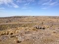
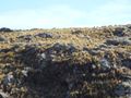
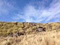
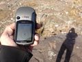
The hash was located in a high spot, approximately 200 meters over a nearby hill west of the road. I was thrilled, because I got three achievements in one single lucky fluke: My first Land geohash achievement, the Birthday Geohash Achievement and the Virgin Graticule achievement!
I took some pictures of the view from the hash, and one of my national ID booklet ([DNI]) showing my birthdate to claim my Birthday Geohash. I present thee the pictures of my province in their full glory for your viewing pleasure.
Photos
Our car is the first from the right
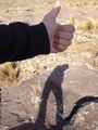
Yours truly waving at the camera
SO waving at the other camera
This is the right spot!
- Error creating thumbnail: Unable to save thumbnail to destination
Happy birthday to me!
Hi there
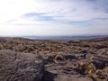
View to the NorthEast from the hashpoint
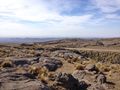
View to the East from the hashpoint


Achievements
Onicofago earned the Land geohash achievement
|
Onicofago earned the Graticule Unlocked Achievement
|
Onicofago earned the Birthday Geohash Achievement
|