Difference between revisions of "2012-08-06 50 10"
imported>Rincewind (→Photos) |
imported>FippeBot m (Location) |
||
| (8 intermediate revisions by 3 users not shown) | |||
| Line 1: | Line 1: | ||
| − | |||
| − | |||
| − | |||
| − | |||
| − | |||
| − | |||
| − | |||
| − | |||
| − | |||
| − | |||
{{meetup graticule | {{meetup graticule | ||
| lat=50 | | lat=50 | ||
| Line 15: | Line 5: | ||
}} | }} | ||
| − | |||
__NOTOC__ | __NOTOC__ | ||
== Location == | == Location == | ||
| Line 22: | Line 11: | ||
== Participants == | == Participants == | ||
* [[User:Mampfred|Mampfred]] | * [[User:Mampfred|Mampfred]] | ||
| − | * [[User:Rincewind|Rincewind]] | + | * [[User:Rincewind|Rincewind]] |
| + | * [[User:Yakamoz|Yakamoz]] | ||
== Plans == | == Plans == | ||
| − | I was intrigued as soon as I saw the location on Friday. Mampfred was... less intrigued by the prospect of water, but hoped for a boat to materialize. I tried phoning the hotel hundred meters from the hash, but they were apparently closed or had their day off. Yet I found another contact telling me that, while not strictly allowed, bathing was absolutely common in the lake and safe even in the area of the drainage, since it is 14m underwater and has little throughput. I now had an official goal. Mampfred was even less intrigued of swimming, but came along, and so did | + | I was intrigued as soon as I saw the location on Friday. Mampfred was... less intrigued by the prospect of water, but hoped for a boat to materialize. I tried phoning the hotel hundred meters from the hash, but they were apparently closed or had their day off. Yet I found another contact telling me that, while not strictly allowed, bathing was absolutely common in the lake and safe even in the area of the drainage, since it is 14m underwater and has little throughput. I now had an official goal. Mampfred was even less intrigued of swimming, but came along, and so did [[User:Yakamoz|Yakamoz]]. |
== Expedition == | == Expedition == | ||
We drove to the lake with the car navigation unit and parked next to it, after some very bumpy roads that were about the worst new roads I ever saw. | We drove to the lake with the car navigation unit and parked next to it, after some very bumpy roads that were about the worst new roads I ever saw. | ||
We then walked onto the dam itself until we had only 30m left and the gps' compass pointed straight onto the water... Off we went. | We then walked onto the dam itself until we had only 30m left and the gps' compass pointed straight onto the water... Off we went. | ||
| − | + | Yakamoz was in peace with her position of photographer, while Mampfred wasn't quite so content with his swimmer status. His concerns (and complaints) stopped abruptly after he reached the water's edge and, carefully testing it, found it warm instead of icy cold. I had sealed the GPS in a condom filled with styrofoam packaging pellets and equipped like this we stepped in. | |
(Styrofoam to keep it afloat should I lose grip, visibility underwater was zero so a drop would have been a loss quickly.) | (Styrofoam to keep it afloat should I lose grip, visibility underwater was zero so a drop would have been a loss quickly.) | ||
It was indeed warm and so we rather happily swam some meters into the lake and let ourself be guided by the compass. The usual hash dance was completely unneccessary, after a very short round I had a 0m-shot. Made some more photos and then headed out and to the towels. | It was indeed warm and so we rather happily swam some meters into the lake and let ourself be guided by the compass. The usual hash dance was completely unneccessary, after a very short round I had a 0m-shot. Made some more photos and then headed out and to the towels. | ||
| Line 36: | Line 26: | ||
After quite a long time, a really cool hash again, I think. | After quite a long time, a really cool hash again, I think. | ||
I certainly enjoyed the stupidity of this. :D | I certainly enjoyed the stupidity of this. :D | ||
| − | |||
| − | |||
| − | |||
== Photos == | == Photos == | ||
| − | < | + | <gallery perrow="3" widths="250"> |
| − | Image: | + | Image:2012-08-06_50_10_sign.jpg | Explaining the dam. |
| − | -- | + | Image:2012-08-06_50_10_boats.jpg | Yes, there were boats. Meh. |
| − | + | Image:2012-08-06_50_10_hash.jpg | Looking at the hash from the railing at the dam. | |
Image:2012-08-06_50_10_18-20-28-100.jpg | Preparations, we're going in ... | Image:2012-08-06_50_10_18-20-28-100.jpg | Preparations, we're going in ... | ||
Image:2012-08-06 50 10 swimsuit-grin.jpg | Sh#*, I forgot about the beach body thing. | Image:2012-08-06 50 10 swimsuit-grin.jpg | Sh#*, I forgot about the beach body thing. | ||
| − | |||
Image:2012-08-06 50 10 help.jpg|Help! | Image:2012-08-06 50 10 help.jpg|Help! | ||
Image:2012-08-06 50 10 German-engineering.jpg|German engineering. | Image:2012-08-06 50 10 German-engineering.jpg|German engineering. | ||
Image:2012-08-06 50 10 most-accurate-proof-yet.jpg|Bull's eye. :) | Image:2012-08-06 50 10 most-accurate-proof-yet.jpg|Bull's eye. :) | ||
| + | </gallery> | ||
| + | |||
| + | <gallery perrow="1" widths=800px> | ||
| + | Image:2012-08-06_50_10_panorama.jpg | Panorama of the lake | ||
</gallery> | </gallery> | ||
== Achievements == | == Achievements == | ||
{{#vardefine:ribbonwidth|800px}} | {{#vardefine:ribbonwidth|800px}} | ||
| − | + | {{Water geohash | |
| − | + | | latitude = 50 | |
| − | + | | longitude = 10 | |
| − | + | | date = 2012-08-06 | |
| − | + | | name = Rincewind and Mampfred | |
| − | + | }} | |
| − | |||
| − | |||
| − | |||
| − | |||
| − | |||
| − | |||
[[Category:Expeditions]] | [[Category:Expeditions]] | ||
| − | |||
[[Category:Expeditions with photos]] | [[Category:Expeditions with photos]] | ||
| − | |||
| − | |||
| − | |||
| − | |||
| − | |||
[[Category:Coordinates reached]] | [[Category:Coordinates reached]] | ||
| − | + | {{location|DE|TH|IK}} | |
| − | |||
| − | |||
| − | |||
| − | |||
| − | |||
| − | |||
| − | |||
| − | |||
| − | |||
| − | |||
| − | |||
| − | |||
| − | |||
| − | |||
| − | |||
| − | |||
| − | |||
Latest revision as of 05:25, 13 August 2019
| Mon 6 Aug 2012 in 50,10: 50.7405222, 10.9588775 geohashing.info google osm bing/os kml crox |
Location
In Talsperre Heyda (accumulation lake Heyda) near Ilmenau
Participants
Plans
I was intrigued as soon as I saw the location on Friday. Mampfred was... less intrigued by the prospect of water, but hoped for a boat to materialize. I tried phoning the hotel hundred meters from the hash, but they were apparently closed or had their day off. Yet I found another contact telling me that, while not strictly allowed, bathing was absolutely common in the lake and safe even in the area of the drainage, since it is 14m underwater and has little throughput. I now had an official goal. Mampfred was even less intrigued of swimming, but came along, and so did Yakamoz.
Expedition
We drove to the lake with the car navigation unit and parked next to it, after some very bumpy roads that were about the worst new roads I ever saw. We then walked onto the dam itself until we had only 30m left and the gps' compass pointed straight onto the water... Off we went. Yakamoz was in peace with her position of photographer, while Mampfred wasn't quite so content with his swimmer status. His concerns (and complaints) stopped abruptly after he reached the water's edge and, carefully testing it, found it warm instead of icy cold. I had sealed the GPS in a condom filled with styrofoam packaging pellets and equipped like this we stepped in. (Styrofoam to keep it afloat should I lose grip, visibility underwater was zero so a drop would have been a loss quickly.) It was indeed warm and so we rather happily swam some meters into the lake and let ourself be guided by the compass. The usual hash dance was completely unneccessary, after a very short round I had a 0m-shot. Made some more photos and then headed out and to the towels.
After quite a long time, a really cool hash again, I think. I certainly enjoyed the stupidity of this. :D
Photos
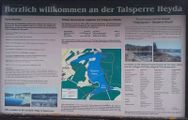
Explaining the dam.
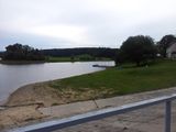
Yes, there were boats. Meh.
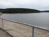
Looking at the hash from the railing at the dam.
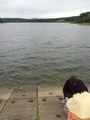
Preparations, we're going in ...
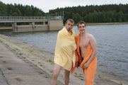
Sh#*, I forgot about the beach body thing.
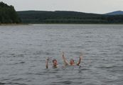
Help!
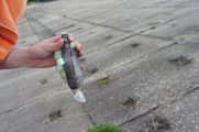
German engineering.
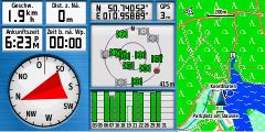
Bull's eye. :)


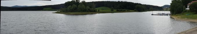
Panorama of the lake

Achievements
Rincewind and Mampfred earned the Water geohash achievement
|