Difference between revisions of "2012-08-11 48 9"
imported>FippeBot m (Location) |
m (Location correction) |
||
| Line 49: | Line 49: | ||
[[Category:Expedition without GPS]] | [[Category:Expedition without GPS]] | ||
[[Category:Coordinates reached]] | [[Category:Coordinates reached]] | ||
| − | {{location|DE|BW| | + | {{location|DE|BW|GP}} |
Revision as of 20:16, 16 May 2020
| Sat 11 Aug 2012 in 48,9: 48.7118274, 9.5016661 geohashing.info google osm bing/os kml crox |
Location
The location was close enough to be reached by bike, and I knew part of the way how to get there. So I just started. From the map it looked like it was on some field.
Participants
Plans
Just getting there and doing a little sport on the way.
Expedition
I used today's geohash for a bike trip. Most of the way went rather smooth. It was 20km as the bird flies and without training I thought it would be easy. But it did get tiresome before the end for me; I noticed I cannot drive the same way as the bird flies. And there were mountains! Well not really, a very small hill, but still. I had to drive quite some more distance to reach the place, as I had to cross a big highway and needed a bride. When I finally reached the place, I found that it was just 2 meters from a bike track. It would have been much easier to reach that place if I had known that before... But well, let's see things positive, it was easier to get back. And the good feeling of having reached my first geohash felt really good :)
Photos
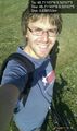
I did it! @48.7118,9.5017

Achievements
DarkMark earned the Land geohash achievement
|
DarkMark earned the Bicycle geohash achievement
|