Difference between revisions of "2012-08-13 46 11"
imported>Werther |
m (Location correction) |
||
| (4 intermediate revisions by 3 users not shown) | |||
| Line 14: | Line 14: | ||
}} | }} | ||
| − | + | ||
__NOTOC__ | __NOTOC__ | ||
== Location == | == Location == | ||
| Line 21: | Line 21: | ||
== Participants == | == Participants == | ||
| − | *[[User:Werther|Werther]] | + | |
| + | * [[User:Werther|Werther]] | ||
== Plans == | == Plans == | ||
| − | As I don't own any vehicle except for a 12-yrs old moped (which is currently broken, anyways), I have to move by public transport. | + | As I don't own any vehicle except for a 12-yrs old moped (which is currently broken, anyways), |
| + | I have to move by public transport. | ||
| + | |||
| + | The local company provides a decent coverage of the area. The coach travel is going to take | ||
| + | about one hour each way. Timetables are also pretty comfortable: I will have half an hour to | ||
| + | get to the spot, take photos and get back to the bus stop (with possibly getting something to | ||
| + | drink/eat at nearby huts in the meanwhile), which is exactly the amount of time I think I'll | ||
| + | need to do everything without being in a rush, and to avoid waiting too much at the bus stop later. | ||
| + | |||
| + | == Expedition == | ||
| + | I was counting on this old GPS we used for car trips until some time ago... | ||
| + | sadly I couldn't find it this morning, so I opted for a good ol' compass and some accurate map study. | ||
| + | |||
| + | The bus trip was fine- departed on time, arrived on time- though when I got off I realized I should | ||
| + | have brought some heavier clothes... it was way colder than I imagined. | ||
| + | |||
| + | I had to walk about 270m on a tarred road, and then turn south and keep walking for 110m. The part of the meadow the hash was in was classified a swamp, but the soil was quite dry and I got to the hash with no problems. | ||
| + | |||
| + | Again, the bus trip home proved as comfortable as my previous one. It was an incredibly smooth exploration- surely not the most exciting, but still a good start. | ||
| + | |||
| + | == Gallery == | ||
| − | + | <gallery> | |
| + | Image:20120813 Trento 001.JPG|Stunning view from my coach window, leaving the city. | ||
| + | Image:20120813 Trento 002.JPG|A quite failed attempt to get some sort of timestamp/proof from the bus' ticket machine. Well, I guess that the stop name ("Viote"), the date and time are still readable. | ||
| + | Image:20120813 Trento 003.JPG|As soon as I started walking, clouds appeared. No rain luckily. | ||
| + | Image:20120813 Trento 004.JPG|Once I walked the first 270 m, I turned south just to see I got to the swampy area. Yaay. | ||
| + | Image:20120813 Trento 005.JPG|After around 110m, I got to my first hash: this mountain pine bush. | ||
| + | Image:20120813 Trento 006.JPG|Oh well, it's grin time I guess... | ||
| + | Image:20120813 Trento 007.JPG|Same road shown in the third picture, but from the bus' window this time. Bye bye, my first hash! | ||
| + | </gallery> | ||
| − | [[Category: | + | [[Category:Expeditions]] |
| − | [[Category:Expedition | + | [[Category:Expeditions with photos]] |
| + | [[Category:Expedition without GPS]] | ||
| + | [[Category:Coordinates reached]] | ||
| + | {{location|IT|TT}} | ||
Latest revision as of 15:06, 28 July 2021
| Mon 13 Aug 2012 in 46,11: 46.0172701, 11.0439384 geohashing.info google osm bing/os kml crox |
Location
Located in a place called Viote- a flat area at the basis of the three tops of Mt.Bondone. An incredibly lucky pick- not only it is around 30 km from where I live, it happens to be very close to an intercity bus stop, it also lies on one of the few spots that don't require a tough hike around...
Participants
Plans
As I don't own any vehicle except for a 12-yrs old moped (which is currently broken, anyways), I have to move by public transport.
The local company provides a decent coverage of the area. The coach travel is going to take about one hour each way. Timetables are also pretty comfortable: I will have half an hour to get to the spot, take photos and get back to the bus stop (with possibly getting something to drink/eat at nearby huts in the meanwhile), which is exactly the amount of time I think I'll need to do everything without being in a rush, and to avoid waiting too much at the bus stop later.
Expedition
I was counting on this old GPS we used for car trips until some time ago... sadly I couldn't find it this morning, so I opted for a good ol' compass and some accurate map study.
The bus trip was fine- departed on time, arrived on time- though when I got off I realized I should have brought some heavier clothes... it was way colder than I imagined.
I had to walk about 270m on a tarred road, and then turn south and keep walking for 110m. The part of the meadow the hash was in was classified a swamp, but the soil was quite dry and I got to the hash with no problems.
Again, the bus trip home proved as comfortable as my previous one. It was an incredibly smooth exploration- surely not the most exciting, but still a good start.
Gallery
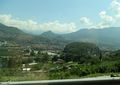
Stunning view from my coach window, leaving the city.

A quite failed attempt to get some sort of timestamp/proof from the bus' ticket machine. Well, I guess that the stop name ("Viote"), the date and time are still readable.
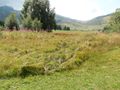
As soon as I started walking, clouds appeared. No rain luckily.
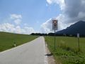
Once I walked the first 270 m, I turned south just to see I got to the swampy area. Yaay.
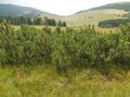
After around 110m, I got to my first hash: this mountain pine bush.
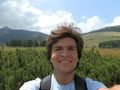
Oh well, it's grin time I guess...
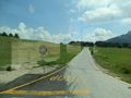
Same road shown in the third picture, but from the bus' window this time. Bye bye, my first hash!


