Difference between revisions of "2012-08-21 51 -1"
From Geohashing
imported>Benjw m (fix cat) |
imported>FippeBot m (Location) |
||
| (One intermediate revision by one other user not shown) | |||
| Line 38: | Line 38: | ||
Image:Ali0sha_2012-08-21_Drag-along.jpg|Proof of the Drag-along Achievement | Image:Ali0sha_2012-08-21_Drag-along.jpg|Proof of the Drag-along Achievement | ||
</gallery> | </gallery> | ||
| + | [[Category:Expeditions]] | ||
| + | [[Category:Expeditions with photos]] | ||
| + | [[Category:Coordinates reached]] | ||
| + | {{location|GB|ENG|OXF}} | ||
Latest revision as of 05:44, 13 August 2019
| Tue 21 Aug 2012 in 51,-1: 51.7228289, -1.1107242 geohashing.info google osm bing/os kml crox |
Location
A field near Cuddleston, east of Oxford, at around 2pm.
Participants
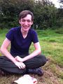
- Ali0sha
- Ellie and Peter (a friend and a brother)
Expedition
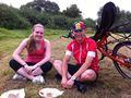
Having bribed them with the prospect of a picnic of tuna mayonnaise sandwiches, I set out on 'a little cycle ride into the country' with my friends, and 10km later we found ourselves standing more-or-less next to the field in which the hash lay. Baulking at the thought of eating a picnic sitting on recently harvested stubble, we sat in the next field to eat, then I traipsed across and got proof (amongst great protestation from the thus far unsuspecting tag-alongs) and returned. Dead easy.
Tracklog
Achievements
Ali0sha earned the Cycling Land Picnic Drag-along Achievement
|
Gallery
Proof of the Picnic Achievement (NB the brightly-coloured plate and the napkin)
Proof of the Drag-along Achievement

