Difference between revisions of "2012-08-29 55 13"
imported>Fasanen (Hej Simon. Nådde hashen och lämnade ett meddelande vid vägkanten. Hittade en geocache vid lundagränsen som du kan passa på att logga om du inte redan gjort det.) |
imported>Fasanen (An expedition) |
||
| Line 1: | Line 1: | ||
| − | + | {{meetup graticule | |
| − | |||
| − | |||
| − | |||
| − | |||
| − | |||
| − | |||
| − | |||
| − | |||
| − | |||
| − | {{meetup graticule | ||
| lat=55 | | lat=55 | ||
| lon=13 | | lon=13 | ||
| Line 15: | Line 5: | ||
}} | }} | ||
| − | |||
__NOTOC__ | __NOTOC__ | ||
== Location == | == Location == | ||
| − | + | On the road just south of Stora Råby. | |
== Participants == | == Participants == | ||
| − | + | [[User:Fasanen|Fasanen]] | |
| − | |||
| − | == | + | == 1st Expedition == |
| − | + | This was a nice day to have some geohashing for lunch. I emailed Llavids in the morning but he could not make it until later so I went by myself. From the map the coordinates looked to be on (or very close to) the road leading from Kyrkheddinge to Lund so it was likely to be an easy geohash. | |
| − | + | About lunch time the fog had cleared and left office. I did not turn on the navigation software until a few hundred meters from the geohash and I feared for a while that I would not be able to get the coordinates as my service provider seemed to have serious problems with data traffic. Finally I managed to get the few pieces of data needed to use geohashdroid and parked just next to the hash. | |
| − | |||
| − | + | I wrote a note to Llavids and put it on the ground by the roadside. After taking some photographs I left, drove through the geohash at 70 km/h and just after some hundred meters I passed one of many border signs marking the city limits of Lund. From the back of my mind I recollected that there was a series of geocaches placed by these locations so I stopped the car and found the cache at the first place I looked. The landscape was completely flat and the geohash was visible form the cache. | |
| − | + | ||
| + | Before heading back do the office desk I grabbed a burger at an American junk food establishment. | ||
== Photos == | == Photos == | ||
| − | |||
| − | |||
| − | |||
<gallery perrow="5"> | <gallery perrow="5"> | ||
| Line 44: | Line 29: | ||
== Achievements == | == Achievements == | ||
{{#vardefine:ribbonwidth|800px}} | {{#vardefine:ribbonwidth|800px}} | ||
| − | + | {{land geohash | latitude=55 | longitude=13 | date=2012-08-29 | name=Fasanen}} | |
| + | {{Speed racer | ||
| + | | latitude = 55 | ||
| + | | longitude = 13 | ||
| + | | date = 2012-08-29 | ||
| + | | name = Fasanen | ||
| + | | speed = 70 km/h | ||
| + | }} | ||
| + | {{Hash collision | latitude = 55 | longitude = 13 | date = 2012-08-29 | name = Fasanen | link =http://www.geocaching.com/seek/cache_details.aspx?guid=64790a77-9cfb-43e0-bf90-4a4cf6758e92 | id = GC2ZATR | distance = 0.47 km | honor }} | ||
| − | |||
| − | |||
| − | |||
| − | |||
| − | |||
| − | |||
| − | |||
| − | |||
| − | |||
[[Category:Expeditions]] | [[Category:Expeditions]] | ||
| − | |||
[[Category:Expeditions with photos]] | [[Category:Expeditions with photos]] | ||
| − | |||
| − | |||
| − | |||
| − | |||
| − | |||
[[Category:Coordinates reached]] | [[Category:Coordinates reached]] | ||
| − | + | [[Category:Sweden]] | |
| − | |||
| − | |||
| − | |||
| − | |||
| − | |||
| − | |||
| − | |||
| − | |||
| − | |||
| − | |||
| − | |||
| − | |||
| − | |||
| − | |||
| − | [[Category: | ||
| − | |||
| − | |||
Revision as of 20:37, 29 August 2012
| Wed 29 Aug 2012 in 55,13: 55.6807366, 13.2261487 geohashing.info google osm bing/os kml crox |
Location
On the road just south of Stora Råby.
Participants
1st Expedition
This was a nice day to have some geohashing for lunch. I emailed Llavids in the morning but he could not make it until later so I went by myself. From the map the coordinates looked to be on (or very close to) the road leading from Kyrkheddinge to Lund so it was likely to be an easy geohash.
About lunch time the fog had cleared and left office. I did not turn on the navigation software until a few hundred meters from the geohash and I feared for a while that I would not be able to get the coordinates as my service provider seemed to have serious problems with data traffic. Finally I managed to get the few pieces of data needed to use geohashdroid and parked just next to the hash.
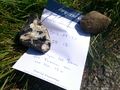
I wrote a note to Llavids and put it on the ground by the roadside. After taking some photographs I left, drove through the geohash at 70 km/h and just after some hundred meters I passed one of many border signs marking the city limits of Lund. From the back of my mind I recollected that there was a series of geocaches placed by these locations so I stopped the car and found the cache at the first place I looked. The landscape was completely flat and the geohash was visible form the cache.
Before heading back do the office desk I grabbed a burger at an American junk food establishment.
Photos
Hej Simon. Nådde hashen och lämnade ett meddelande vid vägkanten. Hittade en geocache vid lundagränsen som du kan passa på att logga om du inte redan gjort det.

Achievements
Fasanen earned the Land geohash achievement
|

Fasanen earned the Hash collision achievement
|