Difference between revisions of "2012-08-29 55 13"
imported>Fasanen (An expedition message sent via Geohash Droid for Android.) |
imported>FippeBot m (Location) |
||
| (8 intermediate revisions by 2 users not shown) | |||
| Line 1: | Line 1: | ||
| − | + | {{meetup graticule | |
| − | |||
| − | |||
| − | |||
| − | |||
| − | |||
| − | |||
| − | |||
| − | |||
| − | |||
| − | {{meetup graticule | ||
| lat=55 | | lat=55 | ||
| lon=13 | | lon=13 | ||
| Line 15: | Line 5: | ||
}} | }} | ||
| − | |||
__NOTOC__ | __NOTOC__ | ||
== Location == | == Location == | ||
| − | + | On the road just south of Stora Råby. | |
== Participants == | == Participants == | ||
| − | + | [[User:Fasanen|Fasanen]] | |
| − | |||
| − | == | + | == 1st Expedition == |
| − | + | This was a nice day to have some geohashing for lunch. I emailed Llavids in the morning but he could not make it until later so I went by myself. From the map the coordinates looked to be on (or very close to) the road leading from Kyrkheddinge to Lund so it was likely to be an easy geohash. | |
| + | |||
| + | About lunch time the fog had cleared and left office. I did not turn on the navigation software until a few hundred meters from the geohash and I feared for a while that I would not be able to get the coordinates as my service provider seemed to have serious problems with data traffic. Finally I managed to get the few pieces of data needed to use geohashdroid and parked just next to the hash. | ||
| − | + | I wrote a note to Llavids and put it on the ground by the roadside. After taking some photographs I left, drove through the geohash at 70 km/h and just after some hundred meters I passed one of many border signs marking the city limits of Lund. From the back of my mind I recollected that there was a series of geocaches placed by these locations so I stopped the car and found the cache at the first place I looked. The landscape was completely flat and the geohash was visible form the cache. | |
| − | |||
| − | + | Before heading back do the office desk I grabbed a burger at an American junk food establishment. | |
| − | |||
== Photos == | == Photos == | ||
| − | |||
| − | |||
| − | |||
<gallery perrow="5"> | <gallery perrow="5"> | ||
| + | |||
| + | Image:551320120829_01.jpg | Left a note for Llavids | ||
| + | Image:551320120829_02.jpg | The geohash with note | ||
| + | Image:551320120829_03.jpg | Not really a grin, is it? | ||
| + | Image:551320120829_04.jpg | Lund city limits | ||
| + | Image:551320120829_05.jpg | There is a cache hidden in the picture | ||
| + | Image:551320120829_06.jpg | Road heading south | ||
| + | Image:551320120829_07.png | Proof | ||
</gallery> | </gallery> | ||
== Achievements == | == Achievements == | ||
{{#vardefine:ribbonwidth|800px}} | {{#vardefine:ribbonwidth|800px}} | ||
| − | + | {{land geohash | latitude=55 | longitude=13 | date=2012-08-29 | name=Fasanen}} | |
| + | {{Speed racer | ||
| + | | latitude = 55 | ||
| + | | longitude = 13 | ||
| + | | date = 2012-08-29 | ||
| + | | name = Fasanen | ||
| + | | speed = 70 km/h | ||
| + | }} | ||
| + | |||
| + | {{Hash collision | latitude = 55 | longitude = 13 | date = 2012-08-29 | name = Fasanen | link =http://www.geocaching.com/seek/cache_details.aspx?guid=64790a77-9cfb-43e0-bf90-4a4cf6758e92 | id = GC2ZATR | distance = 0.47 km | honor }} | ||
| − | + | == Participants == | |
| − | + | [[User:Llavids|Llavids]] | |
| − | [[ | ||
| − | + | == Plans == | |
| − | + | Try to make it during the day, couldn't make it when Fasanen went there. | |
| − | |||
| − | |||
| − | < | + | == 2nd Expedition == |
| − | + | Had to get there after work. Had cars behind me as I closed up on the geohash so I had to drive by at normal speed. Stopped and returned when I got the chance, returned and found parking spot used for tractors. Walked up to the geohash looking for the marks of Fasanen. Found a note, nice, didn't have to search around with the GPS to find ground zero. Took some photos and said hello to a running man and a bicyclist that went by before returning to Stora Råby, to drive home. Got a phone call and it was my neighbor who called me, and he was leaving work driving just behind me, wondering what I was doing in Stora Råby, his working office. Didn't know it was in Stora Råby, but apparently the geohash was close to his work. | |
| − | -- | + | |
| − | + | == Photos == | |
| − | + | <gallery perrow="5"> | |
| − | + | Image:20120829-55-13-01-Proof.png|Proof | |
| − | -- | + | Image:20120829-55-13-02-Satellite.png|Satellite map |
| − | + | Image:20120829-55-13-03-Fasanens-note.JPG|Fasanen note | |
| − | + | Image:20120829-55-13-04-The-grin.JPG|The grin | |
| − | + | Image:20120829-55-13-05-North.JPG|North | |
| + | Image:20120829-55-13-06-East.JPG|East | ||
| + | Image:20120829-55-13-07-South.JPG|South | ||
| + | Image:20120829-55-13-08-West.JPG|West | ||
| + | Image:20120829-55-13-09-Up.JPG|Up | ||
| + | Image:20120829-55-13-10-Råby.JPG|Råby | ||
| + | Image:20120829-55-13-11-Geohash-car-and-the-runner.JPG|Geohash car and runner | ||
| + | Image:20120829-55-13-12-Bicyclist.JPG|Bicyclist | ||
| + | Image:20120829-55-13-13-The-view.JPG|The view | ||
| + | </gallery> | ||
| + | == Achievements == | ||
| + | {{#vardefine:ribbonwidth|800px}} | ||
| − | -- | + | {{ land geohash | latitude=55 | longitude=13 | date=2012-08-29 | name=[[User:Llavids|Llavids]] }} |
| − | |||
| − | |||
| − | |||
| − | [[ | ||
| − | |||
| − | |||
| − | |||
| − | + | {{ Speed racer | latitude = 55 | longitude = 13 | date = 2012-08-29 | name = [[User:Llavids|Llavids]] | speed = 70 km/h }} | |
| − | |||
| − | |||
| − | |||
| − | [[ | ||
| − | + | [[Category:Expeditions]] | |
| + | [[Category:Expeditions with photos]] | ||
| + | [[Category:Coordinates reached]] | ||
| + | [[Category:Sweden]] | ||
| + | {{location|SE|M}} | ||
Latest revision as of 05:52, 13 August 2019
| Wed 29 Aug 2012 in 55,13: 55.6807366, 13.2261487 geohashing.info google osm bing/os kml crox |
Location
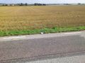
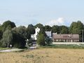
On the road just south of Stora Råby.
Participants
1st Expedition
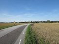
This was a nice day to have some geohashing for lunch. I emailed Llavids in the morning but he could not make it until later so I went by myself. From the map the coordinates looked to be on (or very close to) the road leading from Kyrkheddinge to Lund so it was likely to be an easy geohash.
About lunch time the fog had cleared and left office. I did not turn on the navigation software until a few hundred meters from the geohash and I feared for a while that I would not be able to get the coordinates as my service provider seemed to have serious problems with data traffic. Finally I managed to get the few pieces of data needed to use geohashdroid and parked just next to the hash.
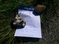
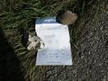
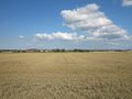
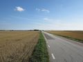
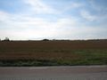
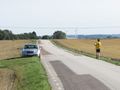
I wrote a note to Llavids and put it on the ground by the roadside. After taking some photographs I left, drove through the geohash at 70 km/h and just after some hundred meters I passed one of many border signs marking the city limits of Lund. From the back of my mind I recollected that there was a series of geocaches placed by these locations so I stopped the car and found the cache at the first place I looked. The landscape was completely flat and the geohash was visible form the cache.
Before heading back do the office desk I grabbed a burger at an American junk food establishment.
Photos
Left a note for Llavids
The geohash with note
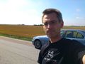
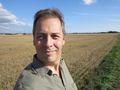
Not really a grin, is it?

Lund city limits
There is a cache hidden in the picture
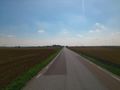
Road heading south
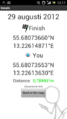
Proof


Achievements
Fasanen earned the Land geohash achievement
|

Fasanen earned the Hash collision achievement
|
Participants
Plans
Try to make it during the day, couldn't make it when Fasanen went there.
2nd Expedition
Had to get there after work. Had cars behind me as I closed up on the geohash so I had to drive by at normal speed. Stopped and returned when I got the chance, returned and found parking spot used for tractors. Walked up to the geohash looking for the marks of Fasanen. Found a note, nice, didn't have to search around with the GPS to find ground zero. Took some photos and said hello to a running man and a bicyclist that went by before returning to Stora Råby, to drive home. Got a phone call and it was my neighbor who called me, and he was leaving work driving just behind me, wondering what I was doing in Stora Råby, his working office. Didn't know it was in Stora Råby, but apparently the geohash was close to his work.
Photos
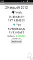
Proof
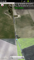
Satellite map
Fasanen note
The grin
North
East
South
West
Up
Råby
Geohash car and runner
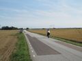
Bicyclist
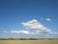
The view


Achievements
Llavids earned the Land geohash achievement
|