Difference between revisions of "2012-09-03 31 -81"
imported>DrCanadianNinja |
m (per Renaming Proposal) |
||
| (8 intermediate revisions by 3 users not shown) | |||
| Line 1: | Line 1: | ||
| + | {{Advert}} | ||
| + | |||
{{meetup graticule | {{meetup graticule | ||
| map=<map lat="31" lon="-81" date="2012-09-03" /> | | map=<map lat="31" lon="-81" date="2012-09-03" /> | ||
| Line 14: | Line 16: | ||
=== Geohashers === | === Geohashers === | ||
| − | * [[user: | + | * [[user:Geoffistopheles|Geoff]] |
=== The Adventure === | === The Adventure === | ||
| Line 35: | Line 37: | ||
Now, in terms of marking it, this was where I faltered earlier in the morning. Where do you place a playing card so that it doesn't get picked up by the grounds crew? At the point won't work, no one would actually go in there for a ball. Just outside would look like trash, as would sitting it at the tee. Eventually, I realized my problem was with the playing card itself - why don't I leave a golf ball? So at the beginning of the round, I wrote out the coordinates on a ball and left it by the yellow tee of the 7th hole. Problem solved! | Now, in terms of marking it, this was where I faltered earlier in the morning. Where do you place a playing card so that it doesn't get picked up by the grounds crew? At the point won't work, no one would actually go in there for a ball. Just outside would look like trash, as would sitting it at the tee. Eventually, I realized my problem was with the playing card itself - why don't I leave a golf ball? So at the beginning of the round, I wrote out the coordinates on a ball and left it by the yellow tee of the 7th hole. Problem solved! | ||
| − | I actually birdied the eighth hole to my own great surprise, but | + | I actually birdied the eighth hole to my own great surprise. As mentioned earlier, my best drives slice to the right, and in this case it means I have to aim for the water. I connect solidly but I don't really get under it, so there's very little vertical movement up. It starts to curve, but I figure it's going to be dead in the water. It hits the middle, skips on the water three times, and at that point I'm laughing far too hard to really watch the ball. I head on over to the last place I found it and hey, it's a ball! Only it's got a nice green stripe on it, so it's not my ball. Confused, I look around for it... and glance at the hole to see it sitting maybe five feet from the hole. There's a small map of the hole that I attached with the weird flight path of the ball, just to get a better idea of what happened, because I still don't. |
| + | |||
| + | By the time I had finished the 9th hole, as mntioned earlier, I had golfed half as many holes as I wanted but just as long as I had planned, so I returned the cart and left for home. | ||
| + | |||
== Gallery == | == Gallery == | ||
<gallery caption="Photo Gallery" widths="200px" heights="200px" perrow="3"> | <gallery caption="Photo Gallery" widths="200px" heights="200px" perrow="3"> | ||
| Line 42: | Line 47: | ||
Image:2012-09-03_31_-81_SeventhHole.jpg|The view of the geohash hole from the yellow tees. | Image:2012-09-03_31_-81_SeventhHole.jpg|The view of the geohash hole from the yellow tees. | ||
Image:2012-09-03_31_-81_GPS.jpg|Success! One day I'll learn how to take pictures without glare. | Image:2012-09-03_31_-81_GPS.jpg|Success! One day I'll learn how to take pictures without glare. | ||
| − | Image:2012-09-03_31_-81_GeohashE.jpg| | + | Image:2012-09-03_31_-81_GeohashE.jpg|View of the geohash towards the road. |
| − | Image:2012-09-03_31_-81_GeohashW.jpg| | + | Image:2012-09-03_31_-81_GeohashW.jpg|View of the geohash towards the course. |
Image:2012-09-03_31_-81_Geohasher.jpg|Hooray! I don't look nearly as tired as I felt there. | Image:2012-09-03_31_-81_Geohasher.jpg|Hooray! I don't look nearly as tired as I felt there. | ||
Image:2012-09-03_31_-81_GolfBall.jpg|Putted to the hashpoint. | Image:2012-09-03_31_-81_GolfBall.jpg|Putted to the hashpoint. | ||
Image:2012-09-03_31_-81_Marker.jpg|Left at the yellow tees of the 7th hole. | Image:2012-09-03_31_-81_Marker.jpg|Left at the yellow tees of the 7th hole. | ||
| + | Image:2012-09-03_31_-81_SeventhHoleMap.jpg|The arrow is pointing towards the geohash offscreen. | ||
| + | Image:2012-09-03_31_-81_EighthHole.jpg|My ridiculous opening drive that led to a birdie. Skipped on the water three times, hit the rough with enough speed that it popped up and landed on the green. | ||
</gallery> | </gallery> | ||
| Line 52: | Line 59: | ||
== Achieveables == | == Achieveables == | ||
Admit One is a possibility, but there's nothing stopping someone from parking on the nearby road and just venturing into the woods. | Admit One is a possibility, but there's nothing stopping someone from parking on the nearby road and just venturing into the woods. | ||
| − | {{ | + | {{Graticule unlocked |
| latitude = 31 | | latitude = 31 | ||
| longitude = -81 | | longitude = -81 | ||
| date = 2012-09-03 | | date = 2012-09-03 | ||
| − | | name = [[user: | + | | name = [[user:Geoffistopheles|Geoff]] |
| image = 2012-09-03_31_-81_Geohasher.jpg | | image = 2012-09-03_31_-81_Geohasher.jpg | ||
| Line 65: | Line 72: | ||
| longitude = -81 | | longitude = -81 | ||
| date = 2012-09-03 | | date = 2012-09-03 | ||
| − | | name = [[user: | + | | name = [[user:Geoffistopheles|Geoff]] |
| image = 2012-09-03_31_-81_GolfBall.jpg | | image = 2012-09-03_31_-81_GolfBall.jpg | ||
| + | }} | ||
| + | {{Last man standing | ||
| + | | latitude = 31 | ||
| + | | longitude = -81 | ||
| + | | date = 2012-09-03 | ||
| + | | name = [[user:Geoffistopheles|Geoff]] | ||
| + | | image = 2012-09-03_31_-81_Geohasher.jpg | ||
}} | }} | ||
{{Minesweeper geohash | {{Minesweeper geohash | ||
| Line 77: | Line 91: | ||
| s = true | | s = true | ||
| se = true | | se = true | ||
| − | | name = [[user: | + | | name = [[user:Geoffistopheles|Geoff]] |
}} | }} | ||
| + | {{Regional geohashing | name = [[user:Geoffistopheles|Geoff]] | region = Camden County, Georgia | count = 2 }} | ||
[[Category:Expeditions]] | [[Category:Expeditions]] | ||
[[Category:Expeditions with photos]] | [[Category:Expeditions with photos]] | ||
[[Category:Coordinates reached]] | [[Category:Coordinates reached]] | ||
| + | {{location|US|GA|CD}} | ||
Latest revision as of 05:32, 20 March 2024
| Have you seen our geohashing marker? We'd love to hear from you! Click here to say "hi" and tell us what you've seen!
Curious about what geohashing is? Read more! |
| Mon 3 Sep 2012 in Waverly, Georgia: 31.1008130, -81.5884483 geohashing.info google osm bing/os kml crox |
Expedition
The Plan
In the trees off the 7th hole in Golf Club at Sanctuary Cove. I've got a tee time for 8:10 AM, which will hopefully let me play the round before the day gets too overbearing. Erica is not a golfer and has no desire to play, so she'll be sitting this one out.
Geohashers
The Adventure
Woke myself up at 6:00, and despite notes to myself urging to leave by 6:30, it was closer to 6:50 before I headed out. The drive was one of those exceedingly boring ones of just getting on I-95 and going north. It was about an hour drive, and the only thing that livened it up was Georgia State Patrol whipping by me at a hundred miles an hour to pull someone over. (Not an exaggeration, I'm pretty sure it was going that fast.)
My plan was to hit the links at 8:10, allocate myself three hours to finish the game and make the geohash, then hit the road to be back by 12:30. Technically, I achieved all three of those goals. First of all, it's imperative to know that I am terrible at golf. My high hopes were that if I could keep my score in double digits, it'd be a smashing success. For the record, par at Sanctuary Cove is 71, so you can see I had really high hopes for myself. I also figured that, considering the amount of stops I'd have to make to hit the ball again, ten minutes per hole was probably a high but accurate guess.
I only played nine holes. The party in front of me was so slow that it took twenty minutes per hole, aka the entire allotted time I had set for myself, just to finish half the game. Par was 36, I scored 54. Not exactly a smashing success, but well enough, I suppose.
It was about as eventful as bad golf can be until I hit the 7th hole. I realized as I was driving up to the tee that this hole was set up perfectly for me to try and actually hit the ball to the geohash. When I drive, I have a wicked slice on the ball, but there were bunkers in front of me as a visual reference and the hashpoint was in the trees to the right! The party in front of me allowed me to play through, so I took aim, fired, and for once, my drive went exactly as I planned it, right into the trees.
Said party was helpful and pointed out my ball hadn't gotten too deep in the trees. I thanked them, picked it up, and continued into the trees. The following exchange took place: "Wait, where are you going?" "Oh, I actually meant to hit it further into the trees, so I'm just taking it there." "Why?" "The internet demands this of me."
By the time I came back from the point, they were long gone. Once again, satellite imagery showed the trees as being much more open than they were. I used my putter to move some of the overgrowth out of the way, which thankfully stopped immediately thereafter and it was a fairly open clearing. I found the spot, took my pictures, then dropped the ball and putted to the hashpoint. Success!
Now, in terms of marking it, this was where I faltered earlier in the morning. Where do you place a playing card so that it doesn't get picked up by the grounds crew? At the point won't work, no one would actually go in there for a ball. Just outside would look like trash, as would sitting it at the tee. Eventually, I realized my problem was with the playing card itself - why don't I leave a golf ball? So at the beginning of the round, I wrote out the coordinates on a ball and left it by the yellow tee of the 7th hole. Problem solved!
I actually birdied the eighth hole to my own great surprise. As mentioned earlier, my best drives slice to the right, and in this case it means I have to aim for the water. I connect solidly but I don't really get under it, so there's very little vertical movement up. It starts to curve, but I figure it's going to be dead in the water. It hits the middle, skips on the water three times, and at that point I'm laughing far too hard to really watch the ball. I head on over to the last place I found it and hey, it's a ball! Only it's got a nice green stripe on it, so it's not my ball. Confused, I look around for it... and glance at the hole to see it sitting maybe five feet from the hole. There's a small map of the hole that I attached with the weird flight path of the ball, just to get a better idea of what happened, because I still don't.
By the time I had finished the 9th hole, as mntioned earlier, I had golfed half as many holes as I wanted but just as long as I had planned, so I returned the cart and left for home.
Gallery
- Photo Gallery

Definitely set up for events and the like.

The opening sign.

The view of the geohash hole from the yellow tees.
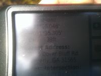
Success! One day I'll learn how to take pictures without glare.
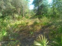
View of the geohash towards the road.
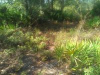
View of the geohash towards the course.

Hooray! I don't look nearly as tired as I felt there.
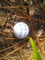
Putted to the hashpoint.
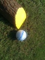
Left at the yellow tees of the 7th hole.
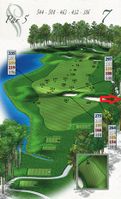
The arrow is pointing towards the geohash offscreen.
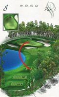
My ridiculous opening drive that led to a birdie. Skipped on the water three times, hit the rough with enough speed that it popped up and landed on the green.


Achieveables
Admit One is a possibility, but there's nothing stopping someone from parking on the nearby road and just venturing into the woods.
Geoff earned the Graticule Unlocked Achievement
|
Geoff earned the Golf Geohash Achievement
|
Geoff earned the Last man standing achievement
|
Geoff achieved level 5 of the Minesweeper Geohash achievement
|
Geoff earned the Regional geohashing achievement
|