Difference between revisions of "2012-09-15 47 -122"
imported>OtherJack m (→Photos) |
imported>FippeBot m (Location) |
||
| (6 intermediate revisions by 2 users not shown) | |||
| Line 22: | Line 22: | ||
== Expedition == | == Expedition == | ||
| − | |||
| − | |||
| − | |||
*Arrived Ikea -- [[User:Thomcat|Thomcat]] [http://www.openstreetmap.org/?lat=47.44331857&lon=-122.22446419&zoom=16&layers=B000FTF @47.4433,-122.2245] 15:47, 15 September 2012 (PDT) | *Arrived Ikea -- [[User:Thomcat|Thomcat]] [http://www.openstreetmap.org/?lat=47.44331857&lon=-122.22446419&zoom=16&layers=B000FTF @47.4433,-122.2245] 15:47, 15 September 2012 (PDT) | ||
...and about 45 minutes after that post (4:33pm) we arrived in front of the hash house, within about 30 seconds of each other. My bike ride was beautiful and straightforward, except for climbing up East Hill in Kent at the very end, which was heinously steep (Google indicates a 500-foot stretch of 16% grade, and a lot more than that in the 12% ballpark.) Thom promptly produced some Swedish candy from the Ikea, which turned out to be a somewhat nicer version of Kit-kats. No one seemed to be home at the house, so Thom went ahead and wandered onto their lawn, which was not watered or anything. This gave me moral cover to do the same, and within a few seconds we had the hashpoint. I forgot to take a GPS shot though - I hope you remembered Thom? | ...and about 45 minutes after that post (4:33pm) we arrived in front of the hash house, within about 30 seconds of each other. My bike ride was beautiful and straightforward, except for climbing up East Hill in Kent at the very end, which was heinously steep (Google indicates a 500-foot stretch of 16% grade, and a lot more than that in the 12% ballpark.) Thom promptly produced some Swedish candy from the Ikea, which turned out to be a somewhat nicer version of Kit-kats. No one seemed to be home at the house, so Thom went ahead and wandered onto their lawn, which was not watered or anything. This gave me moral cover to do the same, and within a few seconds we had the hashpoint. I forgot to take a GPS shot though - I hope you remembered Thom? | ||
| − | After brief conversation back at the vehicles, Thom drove on to his | + | After brief conversation back at the vehicles, Thom drove on to his game night and I headed home via 140th Ave SE, Ezell's chicken, the Cedar River trail (excellent, I'll have to come back sometime!) and the west shore of Lake Washington. Not a bad day. |
-- [[User:OtherJack|OtherJack]] 03:10, 16 September 2012 (EDT) | -- [[User:OtherJack|OtherJack]] 03:10, 16 September 2012 (EDT) | ||
| + | |||
| + | After Ikea (a quick in-out, thank you ma'am) I loaded my flatpack Besta and headed for the geohash. Jack was to be there at 4:30, and I swear I hit every red light in 6km. That aside, we arrived, chatted, and scouted the hashpoint successfully. Geohash droid reported "on the spot" as I uploaded the picture of Jack, coordinates on the image. | ||
| + | |||
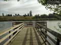
| + | I found the sawed-off post of what was once a fence at the front of the lawn. To this I tacked the Active Geohasher notice. (To whoever is visiting this page, hi!). Leaving the hash site, I went to check out the other thing I spotted on the map - a lake park, complete with dock, and just a bit south. Turns out to be a dog park of sorts - lots of trails, lots of doggie-doo bag dispensers, and a lovely dock with many dragonflies. A few people with dogs off leash, which is fine with me - they were all well behaved. A nice place to have near your house - recommended! | ||
| + | |||
| + | Leaving Clark Lake Park I continued through Puyallup (hello, Fair traffic!) and on to my buddies house for game night. We played one game of Monsters Menace America with the younger kids (Godzilla won) and then two games of Seven Wonders. We tried out a new Cowboy game that looked a lot like the old Avalon Hill game Gunslinger, and chatted about games also, and then called it a night. All but half an Ikea Dark Chocolate bar had been consumed and a fun night had by all. | ||
| + | |||
| + | (Yes, I considered driving south to a 2am geohash in 46, -122, and then my sleep-deprived brain steered me home instead.) | ||
| + | --[[User:Thomcat|Thomcat]] 11:07, 16 September 2012 (EDT) | ||
== Tracklog == | == Tracklog == | ||
| Line 37: | Line 43: | ||
== Photos == | == Photos == | ||
| − | |||
| − | |||
| − | |||
<gallery perrow="5"> | <gallery perrow="5"> | ||
Image:2012-09-15_47_-122_16-41-25-673.jpg | On the spot! [http://www.openstreetmap.org/?lat=47.39099958&lon=-122.17683921&zoom=16&layers=B000FTF @47.3910,-122.1768] | Image:2012-09-15_47_-122_16-41-25-673.jpg | On the spot! [http://www.openstreetmap.org/?lat=47.39099958&lon=-122.17683921&zoom=16&layers=B000FTF @47.3910,-122.1768] | ||
| + | |||
| + | Image:2012-09-15 47 -122 OtherJackGrin.jpg | OtherJack grinning | ||
| + | |||
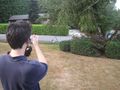
| + | Image:2012-09-15 47 -122 OtherJackShooting.jpg | ||
| + | |||
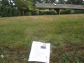
| + | Image:2012-09-15 47 -122 AGMarker.jpg | ||
| + | |||
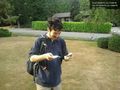
| + | Image:2012-09-15 47 -122 FlatpackAndCandy.jpg | Picked up from Ikea | ||
Image:2012-09-15_47_-122_16-57-34-454.jpg | At Clark Lake Park, just south of the geohash. [http://www.openstreetmap.org/?lat=47.38378494&lon=-122.17388085&zoom=16&layers=B000FTF @47.3838,-122.1739] | Image:2012-09-15_47_-122_16-57-34-454.jpg | At Clark Lake Park, just south of the geohash. [http://www.openstreetmap.org/?lat=47.38378494&lon=-122.17388085&zoom=16&layers=B000FTF @47.3838,-122.1739] | ||
| + | |||
| + | Image:2012-09-15 IMG 3207.JPG | Hash house | ||
| + | |||
| + | Image:2012-09-15 IMG 3208.JPG | Thom grinning | ||
| + | |||
| + | Image:2012-09-15 IMG 3210.JPG | Bike Proof | ||
| + | |||
</gallery> | </gallery> | ||
| − | |||
== Achievements == | == Achievements == | ||
{{#vardefine:ribbonwidth|800px}} | {{#vardefine:ribbonwidth|800px}} | ||
<!-- Add any achievement ribbons you earned below, or remove this section --> | <!-- Add any achievement ribbons you earned below, or remove this section --> | ||
| + | {{Bicycle geohash | ||
| + | | latitude = 47 | ||
| + | | longitude = -122 | ||
| + | | date = 2012-09-15 | ||
| + | | name = [[User:OtherJack|OtherJack]] | ||
| + | | distance = about 45km each way | ||
| − | + | }} | |
| − | |||
| − | |||
[[Category:Expeditions]] | [[Category:Expeditions]] | ||
| − | |||
[[Category:Expeditions with photos]] | [[Category:Expeditions with photos]] | ||
| − | |||
| − | |||
| − | |||
| − | |||
| − | |||
[[Category:Coordinates reached]] | [[Category:Coordinates reached]] | ||
| − | + | {{location|US|WA|KN}} | |
| − | |||
| − | |||
| − | |||
| − | |||
| − | |||
| − | |||
| − | |||
| − | |||
| − | |||
| − | |||
| − | |||
| − | |||
| − | |||
| − | |||
| − | |||
| − | |||
Latest revision as of 06:06, 13 August 2019
| Sat 15 Sep 2012 in Seattle: 47.3909236, -122.1767951 geohashing.info google osm bing/os kml crox |
Location
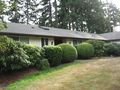
The front yard of a house in Kent.
Participants
Plans
Drive there on Saturday at 4pm, then continue to South Hill for a strategy game night.
- I could bike down, but having to be in the U-district till 2pm means that 4 would be cutting it close. Is 4:30 too late for your schedule? Alternatively I could bus/bike and certainly be there by 4. -- OtherJack 15:24, 14 September 2012 (EDT)
Expedition
- Arrived Ikea -- Thomcat @47.4433,-122.2245 15:47, 15 September 2012 (PDT)
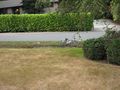
...and about 45 minutes after that post (4:33pm) we arrived in front of the hash house, within about 30 seconds of each other. My bike ride was beautiful and straightforward, except for climbing up East Hill in Kent at the very end, which was heinously steep (Google indicates a 500-foot stretch of 16% grade, and a lot more than that in the 12% ballpark.) Thom promptly produced some Swedish candy from the Ikea, which turned out to be a somewhat nicer version of Kit-kats. No one seemed to be home at the house, so Thom went ahead and wandered onto their lawn, which was not watered or anything. This gave me moral cover to do the same, and within a few seconds we had the hashpoint. I forgot to take a GPS shot though - I hope you remembered Thom?
After brief conversation back at the vehicles, Thom drove on to his game night and I headed home via 140th Ave SE, Ezell's chicken, the Cedar River trail (excellent, I'll have to come back sometime!) and the west shore of Lake Washington. Not a bad day.
-- OtherJack 03:10, 16 September 2012 (EDT)
After Ikea (a quick in-out, thank you ma'am) I loaded my flatpack Besta and headed for the geohash. Jack was to be there at 4:30, and I swear I hit every red light in 6km. That aside, we arrived, chatted, and scouted the hashpoint successfully. Geohash droid reported "on the spot" as I uploaded the picture of Jack, coordinates on the image.
I found the sawed-off post of what was once a fence at the front of the lawn. To this I tacked the Active Geohasher notice. (To whoever is visiting this page, hi!). Leaving the hash site, I went to check out the other thing I spotted on the map - a lake park, complete with dock, and just a bit south. Turns out to be a dog park of sorts - lots of trails, lots of doggie-doo bag dispensers, and a lovely dock with many dragonflies. A few people with dogs off leash, which is fine with me - they were all well behaved. A nice place to have near your house - recommended!
Leaving Clark Lake Park I continued through Puyallup (hello, Fair traffic!) and on to my buddies house for game night. We played one game of Monsters Menace America with the younger kids (Godzilla won) and then two games of Seven Wonders. We tried out a new Cowboy game that looked a lot like the old Avalon Hill game Gunslinger, and chatted about games also, and then called it a night. All but half an Ikea Dark Chocolate bar had been consumed and a fun night had by all.
(Yes, I considered driving south to a 2am geohash in 46, -122, and then my sleep-deprived brain steered me home instead.) --Thomcat 11:07, 16 September 2012 (EDT)
Tracklog
Photos
On the spot! @47.3910,-122.1768
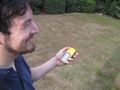
OtherJack grinning
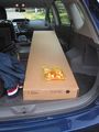
Picked up from Ikea
At Clark Lake Park, just south of the geohash. @47.3838,-122.1739
Hash house

Thom grinning
Bike Proof


Achievements
OtherJack earned the Bicycle geohash achievement
|