Difference between revisions of "2012-09-18 47 -122"
imported>Thomcat ([live picture] Good morning geohash! [http://www.openstreetmap.org/?lat=47.67383744&lon=-122.34789617&zoom=16&layers=B000FTF @47.6738,-122.3479]) |
imported>Thomcat (add photos and details) |
||
| Line 1: | Line 1: | ||
| − | |||
| − | |||
| − | |||
| − | |||
| − | |||
| − | |||
| − | |||
| − | |||
| − | |||
| − | |||
{{meetup graticule | {{meetup graticule | ||
| lat=47 | | lat=47 | ||
| lon=-122 | | lon=-122 | ||
| date=2012-09-18 | | date=2012-09-18 | ||
| + | | graticule_name=Seattle | ||
| + | | graticule_link=Seattle, Washington | ||
}} | }} | ||
| − | |||
__NOTOC__ | __NOTOC__ | ||
== Location == | == Location == | ||
| − | + | On North 62nd street just west of Greenlake. | |
== Participants == | == Participants == | ||
| − | + | *[[User:Thomcat|Thomcat]] | |
| − | |||
== Plans == | == Plans == | ||
| − | + | I can certainly stop again if someone would like to meet. --[[User:Thomcat|Thomcat]] 10:51, 18 September 2012 (EDT) | |
== Expedition == | == Expedition == | ||
| − | + | ''This is probably a couch potato honorable mention for [[User:OtherJack|OtherJack]].'' | |
| − | + | Pulling up the geohash at 6:32 am, I see that it is only 3.8km from my house. As I am ready to go to work, I hop in the car and drive to the spot, checking at a stoplight that sunrise is at 6:51am. Combining the two events, I arrive and have a leisurely minute to leave a nice marker at the spot where geohashdroid landed on the coordinates. Satellite photo shows it to be across the street, where my car is parked in the photo. | |
| − | + | ||
| + | 21 minutes to arrival at the geohash from the announcing of coordinates. I wonder if that's the quickest time to geohash, or if someone has managed sooner? This is strictly a "west of 30" game, because the other guys have the geohash a whole day in advance. | ||
== Photos == | == Photos == | ||
| − | |||
| − | |||
| − | |||
<gallery perrow="5"> | <gallery perrow="5"> | ||
| + | Image:2012-09-18 47 -122 AndroidSunrise.jpg | Android app says Sunrise is at 6:51:29 at this location | ||
| + | Image:2012-09-18 47 -122 Geohasher.jpg | Timed photo, taken while uploading with geohashdroid | ||
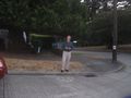
Image:2012-09-18_47_-122_06-53-09-273.jpg | Good morning geohash! [http://www.openstreetmap.org/?lat=47.67383744&lon=-122.34789617&zoom=16&layers=B000FTF @47.6738,-122.3479] | Image:2012-09-18_47_-122_06-53-09-273.jpg | Good morning geohash! [http://www.openstreetmap.org/?lat=47.67383744&lon=-122.34789617&zoom=16&layers=B000FTF @47.6738,-122.3479] | ||
</gallery> | </gallery> | ||
| Line 47: | Line 37: | ||
| − | |||
| − | |||
| − | |||
| − | |||
| − | |||
| − | |||
| − | |||
| − | |||
| − | |||
| − | |||
[[Category:Expeditions]] | [[Category:Expeditions]] | ||
| − | |||
[[Category:Expeditions with photos]] | [[Category:Expeditions with photos]] | ||
| − | |||
| − | |||
| − | |||
| − | |||
| − | |||
[[Category:Coordinates reached]] | [[Category:Coordinates reached]] | ||
| − | |||
| − | |||
| − | |||
| − | |||
| − | |||
| − | |||
| − | |||
| − | |||
| − | |||
| − | |||
| − | |||
| − | |||
| − | |||
| − | |||
| − | |||
| − | |||
| − | |||
| − | |||
Revision as of 14:51, 18 September 2012
| Tue 18 Sep 2012 in Seattle: 47.6738546, -122.3478859 geohashing.info google osm bing/os kml crox |
Location
On North 62nd street just west of Greenlake.
Participants
Plans
I can certainly stop again if someone would like to meet. --Thomcat 10:51, 18 September 2012 (EDT)
Expedition
This is probably a couch potato honorable mention for OtherJack.
Pulling up the geohash at 6:32 am, I see that it is only 3.8km from my house. As I am ready to go to work, I hop in the car and drive to the spot, checking at a stoplight that sunrise is at 6:51am. Combining the two events, I arrive and have a leisurely minute to leave a nice marker at the spot where geohashdroid landed on the coordinates. Satellite photo shows it to be across the street, where my car is parked in the photo.
21 minutes to arrival at the geohash from the announcing of coordinates. I wonder if that's the quickest time to geohash, or if someone has managed sooner? This is strictly a "west of 30" game, because the other guys have the geohash a whole day in advance.
Photos
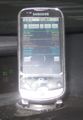
Android app says Sunrise is at 6:51:29 at this location
Timed photo, taken while uploading with geohashdroid

Good morning geohash! @47.6738,-122.3479


