Difference between revisions of "2012-09-18 47 -122"
imported>Thomcat (An expedition message sent via Geohash Droid for Android.) |
imported>FippeBot m (Location) |
||
| (13 intermediate revisions by 2 users not shown) | |||
| Line 1: | Line 1: | ||
| − | |||
| − | |||
| − | |||
| − | |||
| − | |||
| − | |||
| − | |||
| − | |||
| − | |||
| − | |||
{{meetup graticule | {{meetup graticule | ||
| lat=47 | | lat=47 | ||
| lon=-122 | | lon=-122 | ||
| date=2012-09-18 | | date=2012-09-18 | ||
| + | | graticule_name=Seattle | ||
| + | | graticule_link=Seattle, Washington | ||
}} | }} | ||
| − | |||
__NOTOC__ | __NOTOC__ | ||
== Location == | == Location == | ||
| − | + | On North 62nd street just west of Greenlake. | |
== Participants == | == Participants == | ||
| − | + | *[[User:Thomcat|Thomcat]] | |
| − | + | *[[User:OtherJack|OtherJack]] | |
| + | |||
| + | ''This is probably a couch potato honorable mention for [[User:OtherJack|OtherJack]].'' | ||
== Plans == | == Plans == | ||
| − | + | I can certainly stop again if someone would like to meet. --[[User:Thomcat|Thomcat]] 10:51, 18 September 2012 (EDT) | |
| + | :I could make it at any time from about 6:30pm or later. Maybe even a little earlier than that, depends on traffic, bus, etc. getting home from where I am now in Friday Harbor. I will check this page again around 5:30 or 6. I will hit the point at some time regardless of course, can't miss this! -- [[User:OtherJack|OtherJack]] 15:30, 18 September 2012 (EDT) | ||
| + | ::Let's shoot for 7:14pm - then we make it a Fiddler on the Roof hash (Sunrise, Sunset...) --[[User:Thomcat|Thomcat]] 18:03, 18 September 2012 (EDT) | ||
| + | :::I read 5.2km from my house via roads, and google maps even suggests going through 2 alleyways! --[[User:Thomcat|Thomcat]] 20:13, 18 September 2012 (EDT) | ||
| + | :::That works, I'll see you then - and I think it should be easy enough for you to find a good icon picture for your gratuitous ribbon... -- [[User:OtherJack|OtherJack]] 20:42, 18 September 2012 (EDT) | ||
| + | |||
| + | == Expedition #1 == | ||
| + | Pulling up the geohash at 6:32 am, I see that it is only 3.8km from my house. As I am ready to go to work, I hop in the car and drive to the spot, checking at a stoplight that sunrise is at 6:51am. Combining the two events, I arrive and have a leisurely minute to leave a nice marker at the spot where geohashdroid landed on the coordinates. Satellite photo shows it to be across the street, where my car is parked in the photo. | ||
| + | |||
| + | 20 minutes to arrival at the geohash from the announcing of coordinates. I wonder if that's the quickest time to geohash, or if someone has managed sooner? This is strictly a "west of 30" game, because the other guys have the geohash a whole day in advance. | ||
| + | |||
| + | Anyhow, the sun cleared the mountains east of us a bit later than 6:51, and was a blood red due to the smoke in the air from wildfires. By the time I reached work, it was mostly above that haze and could no longer be directly examined for sunspots. | ||
| + | |||
| + | == Expedition #2 == | ||
| + | Hopped on my bike and got out of the house at 7, rode hard to the spot. Took a little more hill on the last bit so I could approach downhill... no OtherJack! A truck parked on my hashmark? | ||
| + | |||
| + | As I made to shake a fist at the heavens, I rode down hill and discovered the truck was parked uphill from my mark, and trundling down the street was [[User:OtherJack|OtherJack]]. It's funny, he kind of looked like a light cycle... --[[User:Thomcat|Thomcat]] 23:15, 18 September 2012 (EDT) | ||
| − | + | ...and indeed I got another Tron hash out of this. A few blocks walking/running down the steep east side of Phinney Ridge trying and failing to make the sunset time, a careful hashdance into and out of the street, a conversation with Thom (and congratulation for his first bike hash in ages), and a nice leisurely walk back up the hill on a different street. When I got home the GPS was still on, thank god, and I saved the track... now I need to figure out what kind of cable I need to get it onto my computer. Don't know when that'll happen but it will. | |
| − | |||
| − | + | This will probably go down as my shortest (in both distance and time) geohash expedition ever. | |
| − | + | ||
| + | -- [[User:OtherJack|OtherJack]] 17:41, 22 September 2012 (EDT) | ||
== Photos == | == Photos == | ||
| − | |||
| − | |||
| − | |||
<gallery perrow="5"> | <gallery perrow="5"> | ||
| + | |||
| + | Image:2012-09-18 47 -122 AndroidSunrise.jpg | Android app says Sunrise is at 6:51:29 at this location | ||
| + | Image:2012-09-18 47 -122 Geohasher.jpg | Timed photo, taken while uploading with geohashdroid | ||
| + | Image:2012-09-18_47_-122_06-53-09-273.jpg | Good morning geohash! [http://www.openstreetmap.org/?lat=47.67383744&lon=-122.34789617&zoom=16&layers=B000FTF @47.6738,-122.3479] | ||
| + | |||
| + | Image:2012-09-18_47_-122_19-19-59-049.jpg | On the spot [http://www.openstreetmap.org/?lat=47.67387306&lon=-122.34789363&zoom=16&layers=B000FTF @47.6739,-122.3479] | ||
| + | |||
| + | Image:2012-09-18 IMG 3214.JPG | ||
| + | Image:2012-09-18 IMG 3215.JPG | ||
| + | Image:2012-09-18 IMG 3216.JPG | ||
| + | Image:2012-09-18 IMG 3218.JPG | Phinney Ridge | ||
| + | Image:2012-09-18 IMG 3219.JPG | Thom's marker lives yet! | ||
| + | |||
| + | |||
</gallery> | </gallery> | ||
| Line 43: | Line 63: | ||
{{#vardefine:ribbonwidth|800px}} | {{#vardefine:ribbonwidth|800px}} | ||
<!-- Add any achievement ribbons you earned below, or remove this section --> | <!-- Add any achievement ribbons you earned below, or remove this section --> | ||
| + | {{Walk geohash | ||
| + | |||
| + | | latitude = 47 | ||
| + | | longitude = -122 | ||
| + | | date = 2012-09-18 | ||
| + | | name = [[User:OtherJack|OtherJack]] | ||
| + | | distance = about 650m (each way) | ||
| + | | image = 2012-09-18_47_-122_19-19-59-049.jpg | ||
| + | }} | ||
| − | + | {{Tron | |
| − | |||
| − | |||
| − | + | | latitude = 47 | |
| − | + | | longitude = -122 | |
| − | [[ | + | | date = 2012-09-18 |
| − | + | | tracklog = (coming) | |
| + | | possessive = his | ||
| + | | name = [[User:OtherJack|OtherJack]] | ||
| − | + | }} | |
| − | + | ||
| − | -- | + | {{Bicycle geohash | latitude = 47 | longitude = -122 | date = 2012-09-18 | name = [[User:Thomcat|Thomcat]] | image = 2012-09-18 IMG 3216.JPG}} |
| − | |||
| − | |||
| − | [ | ||
| − | |||
| − | |||
| − | |||
| − | |||
| + | {{consecutive geohash | ||
| − | + | | count = 2 | |
| − | + | | latitude = 47 | |
| − | - | + | | longitude = -122 |
| − | + | | date = 2012-09-17 | |
| − | + | | name = [[User:Thomcat|Thomcat]] | |
| − | |||
| − | |||
| − | [[ | ||
| − | + | }} | |
| − | |||
| − | |||
| − | |||
| − | |||
| − | + | [[Category:Expeditions]] | |
| + | [[Category:Expeditions with photos]] | ||
| + | [[Category:Coordinates reached]] | ||
| + | {{location|US|WA|KN}} | ||
Latest revision as of 06:10, 13 August 2019
| Tue 18 Sep 2012 in Seattle: 47.6738546, -122.3478859 geohashing.info google osm bing/os kml crox |
Location
On North 62nd street just west of Greenlake.
Participants
This is probably a couch potato honorable mention for OtherJack.
Plans
I can certainly stop again if someone would like to meet. --Thomcat 10:51, 18 September 2012 (EDT)
- I could make it at any time from about 6:30pm or later. Maybe even a little earlier than that, depends on traffic, bus, etc. getting home from where I am now in Friday Harbor. I will check this page again around 5:30 or 6. I will hit the point at some time regardless of course, can't miss this! -- OtherJack 15:30, 18 September 2012 (EDT)
- Let's shoot for 7:14pm - then we make it a Fiddler on the Roof hash (Sunrise, Sunset...) --Thomcat 18:03, 18 September 2012 (EDT)
- I read 5.2km from my house via roads, and google maps even suggests going through 2 alleyways! --Thomcat 20:13, 18 September 2012 (EDT)
- That works, I'll see you then - and I think it should be easy enough for you to find a good icon picture for your gratuitous ribbon... -- OtherJack 20:42, 18 September 2012 (EDT)
- Let's shoot for 7:14pm - then we make it a Fiddler on the Roof hash (Sunrise, Sunset...) --Thomcat 18:03, 18 September 2012 (EDT)
Expedition #1
Pulling up the geohash at 6:32 am, I see that it is only 3.8km from my house. As I am ready to go to work, I hop in the car and drive to the spot, checking at a stoplight that sunrise is at 6:51am. Combining the two events, I arrive and have a leisurely minute to leave a nice marker at the spot where geohashdroid landed on the coordinates. Satellite photo shows it to be across the street, where my car is parked in the photo.
20 minutes to arrival at the geohash from the announcing of coordinates. I wonder if that's the quickest time to geohash, or if someone has managed sooner? This is strictly a "west of 30" game, because the other guys have the geohash a whole day in advance.
Anyhow, the sun cleared the mountains east of us a bit later than 6:51, and was a blood red due to the smoke in the air from wildfires. By the time I reached work, it was mostly above that haze and could no longer be directly examined for sunspots.
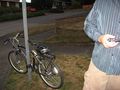
Expedition #2
Hopped on my bike and got out of the house at 7, rode hard to the spot. Took a little more hill on the last bit so I could approach downhill... no OtherJack! A truck parked on my hashmark?
As I made to shake a fist at the heavens, I rode down hill and discovered the truck was parked uphill from my mark, and trundling down the street was OtherJack. It's funny, he kind of looked like a light cycle... --Thomcat 23:15, 18 September 2012 (EDT)
...and indeed I got another Tron hash out of this. A few blocks walking/running down the steep east side of Phinney Ridge trying and failing to make the sunset time, a careful hashdance into and out of the street, a conversation with Thom (and congratulation for his first bike hash in ages), and a nice leisurely walk back up the hill on a different street. When I got home the GPS was still on, thank god, and I saved the track... now I need to figure out what kind of cable I need to get it onto my computer. Don't know when that'll happen but it will.
This will probably go down as my shortest (in both distance and time) geohash expedition ever.
-- OtherJack 17:41, 22 September 2012 (EDT)
Photos
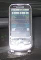
Android app says Sunrise is at 6:51:29 at this location
Timed photo, taken while uploading with geohashdroid

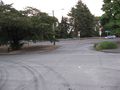
Good morning geohash! @47.6738,-122.3479
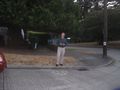
On the spot @47.6739,-122.3479
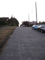
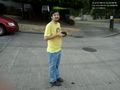
Phinney Ridge
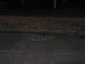
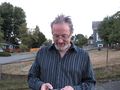
Thom's marker lives yet!


Achievements
OtherJack earned the Walk geohash Achievement
|
OtherJack earned the Tron achievement
|
Thomcat earned the Bicycle geohash achievement
|
Thomcat earned the Consecutive geohash achievement
|