Difference between revisions of "2012-09-22 41 -71"
imported>ChrisG (An expedition message sent via Geohash Droid for Android.) |
imported>FippeBot m (Location) |
||
| (10 intermediate revisions by 2 users not shown) | |||
| Line 1: | Line 1: | ||
| − | |||
<!-- If you did not specify these parameters in the template, please substitute appropriate values for IMAGE, LAT, LON, and DATE (YYYY-MM-DD format) | <!-- If you did not specify these parameters in the template, please substitute appropriate values for IMAGE, LAT, LON, and DATE (YYYY-MM-DD format) | ||
| Line 15: | Line 14: | ||
}} | }} | ||
| − | + | ||
__NOTOC__ | __NOTOC__ | ||
== Location == | == Location == | ||
| − | + | ||
| + | In the west/southbound lane of Route 14/102 in Scituate, Rhode Island, just west of the Clayville Historic District. | ||
== Participants == | == Participants == | ||
| − | + | ||
| − | + | * [[User:ChrisG|ChrisG]] | |
== Plans == | == Plans == | ||
| − | + | ||
| + | I noticed last night that there was a drivable geohash in west central Rhode Island, and I thought I could pull it | ||
| + | off with my morning errands. There's also one in Hartford, Connecticut, but I don't have time to do the double. | ||
| + | With an extra 3 hours, a multihash would have been feasible. | ||
== Expedition == | == Expedition == | ||
| − | + | I already had a morning errand to run - going to get some blueberry honey from a local beekeeper, so I decided to | |
| + | go to the hash before the 4PM appointed time. Seeing how I appear to currently be the only active geohasher in | ||
| + | Rhode Island, I wasn't too worried that I was going to miss someone else. | ||
| + | |||
| + | The drive out to Scituate is relatively scenic once you get out of the urban area. The road crosses the reservoir | ||
| + | that supplies drinking for much of the state - and has some nice rolling hills. I rode much of this about | ||
| + | 14 years and 40 pounds ago. | ||
| + | |||
| + | The hash itself was on Route 14/102 just past the Clayville village, in the middle of the road. I drove through at | ||
| + | the speed limit, then turned around so I could take a couple pictures at the hash point, with my car pulled safely | ||
| + | onto the shoulder. Not much to see here except for a nice granitic boulder outcropping just north of the hash | ||
== Tracklog == | == Tracklog == | ||
| Line 34: | Line 47: | ||
== Photos == | == Photos == | ||
| − | + | ||
| − | + | Now that I'm home, it's possible that I was pointing the wrong direction when I took the pictures. If so, my pic is off by about 10 feet. Sorry about that. I guess you had to be there. | |
| − | + | ||
<gallery perrow="5"> | <gallery perrow="5"> | ||
| + | Image:2012-09-22_41_-71_11-39-40-349.jpg | Speed Racer Hash near Clayville Village [http://www.openstreetmap.org/?lat=41.77550317&lon=-71.68643852&zoom=16&layers=B000FTF @41.7755,-71.6864] | ||
| + | Image:2012-09-22_41_-71_12-42-40-128.jpg | Large boulder near the hashpoint. | ||
</gallery> | </gallery> | ||
== Achievements == | == Achievements == | ||
{{#vardefine:ribbonwidth|800px}} | {{#vardefine:ribbonwidth|800px}} | ||
| − | |||
| + | {{Speed racer | ||
| + | | latitude = 41 | ||
| + | | longitude = -71 | ||
| + | | date = 2012-09-22 | ||
| + | | name = ChrisG | ||
| + | | speed = 50 mph | ||
| + | }} | ||
| + | {{Land geohash | ||
| + | | latitude = 41 | ||
| + | | longitude = -71 | ||
| + | | date = 2012-09-22 | ||
| + | | name = ChrisG | ||
| + | }} | ||
| − | |||
| − | |||
| − | |||
| − | |||
| − | |||
| − | |||
| − | |||
| − | |||
[[Category:Expeditions]] | [[Category:Expeditions]] | ||
| − | + | ||
[[Category:Expeditions with photos]] | [[Category:Expeditions with photos]] | ||
| − | |||
| − | |||
| − | |||
| − | |||
| − | |||
[[Category:Coordinates reached]] | [[Category:Coordinates reached]] | ||
| − | + | {{location|US|RI|PR}} | |
| − | |||
| − | |||
| − | |||
| − | |||
| − | |||
| − | |||
| − | |||
| − | |||
| − | |||
| − | |||
| − | |||
| − | |||
| − | |||
| − | |||
| − | |||
| − | |||
| − | |||
Latest revision as of 06:14, 13 August 2019
| Sat 22 Sep 2012 in 41,-71: 41.7755541, -71.6864571 geohashing.info google osm bing/os kml crox |
Location
In the west/southbound lane of Route 14/102 in Scituate, Rhode Island, just west of the Clayville Historic District.
Participants
Plans
I noticed last night that there was a drivable geohash in west central Rhode Island, and I thought I could pull it off with my morning errands. There's also one in Hartford, Connecticut, but I don't have time to do the double. With an extra 3 hours, a multihash would have been feasible.
Expedition
I already had a morning errand to run - going to get some blueberry honey from a local beekeeper, so I decided to go to the hash before the 4PM appointed time. Seeing how I appear to currently be the only active geohasher in Rhode Island, I wasn't too worried that I was going to miss someone else.
The drive out to Scituate is relatively scenic once you get out of the urban area. The road crosses the reservoir that supplies drinking for much of the state - and has some nice rolling hills. I rode much of this about 14 years and 40 pounds ago.
The hash itself was on Route 14/102 just past the Clayville village, in the middle of the road. I drove through at the speed limit, then turned around so I could take a couple pictures at the hash point, with my car pulled safely onto the shoulder. Not much to see here except for a nice granitic boulder outcropping just north of the hash
Tracklog
Photos
Now that I'm home, it's possible that I was pointing the wrong direction when I took the pictures. If so, my pic is off by about 10 feet. Sorry about that. I guess you had to be there.
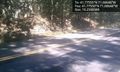
Speed Racer Hash near Clayville Village @41.7755,-71.6864
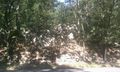
Large boulder near the hashpoint.


Achievements

ChrisG earned the Land geohash achievement
|