Difference between revisions of "2012-09-24 45 -122"
imported>Kydlt |
imported>Benjw (expedition cats) |
||
| Line 45: | Line 45: | ||
[[Category:Expeditions]] | [[Category:Expeditions]] | ||
| − | + | <!--[[Category:Expeditions with photos]]--> | |
| − | [[Category:Expeditions with photos]] | + | [[Category:Coordinates not reached]] |
| − | + | [[Category:Not reached - Mother Nature]] | |
| − | [[Category: | ||
Revision as of 04:22, 26 September 2012
| Mon 24 Sep 2012 in 45,-122: 45.6304091, -122.0137938 geohashing.info google osm bing/os kml crox |
Location
Below Beacon Rock.
Participants
Plans
This one is as close to my house as a Portland grid can be. Its down between HWY 14 and the RR tracks, so two possible approaches. Bing sattelite photo looks promissing, but that clear area could be blackberries 10 ft tall. So let's run down this morning.
Expedition
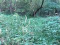
Fail. I parked up above on Hwy 14, and walked the road looking down. Steep, thick trees and undergrowth. There were crosses beside the road where the Road God took some souls. Not a good sign. So then I went back east to the point where some power lines cut from the road down to the RR tracks. Slid down that hill and headed downstream on the tracks. Dropped down of the RR grade and into the woods. Where it wasn't thick trees it was swamp or blackberrys. I tried several deer trails into the the berrys. The closest I got was 280 ft where I got to the deer remains that I suppose the blackberrys killed. So i came home.
Tracklog
Photos
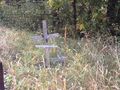
I don't think that I want to go down here.
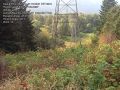
SO I guess htat I'll go down here.
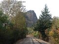
On the RR tracks, I am now below the hash. Beacon Rock looms.
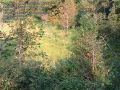
If it looks like grass it's probably swamp.
Blackberry bushes taller than me, with large thorns.

If she couldn't get thru the thorns I'm not going to try anymore.


