Difference between revisions of "2012-09-29 66 25"
imported>Isopekka (Created page with "thumb|left {{meetup graticule | lat=66 | lon=25 | date=2012-09-29 }} == Location == Again in the forest, about 6 km from my home as me...") |
imported>FippeBot m (Location) |
||
| (2 intermediate revisions by one other user not shown) | |||
| Line 15: | Line 15: | ||
| − | Again in the forest, about 6 km from my home as measured from the map, in | + | Again in the forest, about 6 km from my home as measured from the map, in Pahkamaa. |
| Line 43: | Line 43: | ||
<gallery perrow=4> | <gallery perrow=4> | ||
| − | Image:2012-09-29 15.11.45.jpg| 200 m to the Hash."No | + | Image:2012-09-29 15.11.45.jpg| 200 m to the Hash."No trespassing, shooting training area", but... |
Image:2012-09-29 15.21.58.jpg| Hashpoint seen in the left part of the picture, only 20 meters from the forest road. | Image:2012-09-29 15.21.58.jpg| Hashpoint seen in the left part of the picture, only 20 meters from the forest road. | ||
Image:2012-09-29 15.17.24.jpg| The Proof. | Image:2012-09-29 15.17.24.jpg| The Proof. | ||
| Line 81: | Line 81: | ||
[[Category:Expeditions with photos]] | [[Category:Expeditions with photos]] | ||
[[Category:Coordinates reached]] | [[Category:Coordinates reached]] | ||
| + | {{location|FI|10}} | ||
Latest revision as of 06:21, 13 August 2019

| Sat 29 Sep 2012 in 66,25: 66.5718737, 25.7560506 geohashing.info google osm bing/os kml crox |
Contents
Location
Again in the forest, about 6 km from my home as measured from the map, in Pahkamaa.
Participants
Expedition
- By car total 12 km
- Walking total 0.4 km
- Expedition took 1 h
- Physical effort (1-5): 1
I could drive very close to the Hash. The hashpoint situated close a shooting training area, where somebody was training with rifle. But no problem, I saw no bullets flying. So I walked about 200 m to the Hash. I was at the hashpoint about 3:30 p.m. I took small walk with my dogs and returned to the hashpoint at 4:00 p.m. and had my lonely Official Saturday Meetup. Nobody seen there, of course, because in the whole Finland there are only few hashers. Nice trip, typical autumn weather, some rain, some sun.
Photos
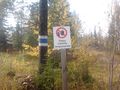
200 m to the Hash."No trespassing, shooting training area", but...
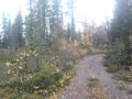
Hashpoint seen in the left part of the picture, only 20 meters from the forest road.
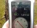
The Proof.
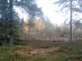
View from the Hash.
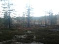
Nearby.


Achievements
isopekka earned the Land geohash achievement
|
isopekka earned the xkcd Nullaturion achievement
|
Geohashing Expeditions and Plans on This Day
Expeditions and Plans
| 2012-09-29 | ||
|---|---|---|
| Singapore, Singapore | Cyazlars | Along Jalan Setia 3/1, Taman Setia Indah, Johor Bahru, Malaysia. |
| Tecate, Mexico | LucasBrown | Atop a ridge near the head of the Tiujana River, just north of the Mexican ... |
| Sacramento, California | Chandru | Anderson Road between Catalina Drive and F Street, North Davis. |
| Portland, Oregon | Jim | On the side of Hwy 30 west of Portland |
| Seattle, Washington | Thomcat, OtherJack | Probable paper company land on the Kitsap. |
| Stuttgart, Germany | User:DarkMark, User:M-o-D | In a corn field between Stuttgart and Ulm. |
| Rovaniemi, Finland | isopekka | Again in the forest, about 6 km from my home as measured from the map, in P... |