Difference between revisions of "2012-10-04 55 37"
imported>Vb (An expedition message sent via Geohash Droid for Android.) |
m |
||
| (24 intermediate revisions by 3 users not shown) | |||
| Line 1: | Line 1: | ||
| − | |||
| − | |||
| − | |||
| − | |||
| − | |||
| − | |||
| − | |||
| − | |||
| − | |||
| − | |||
{{meetup graticule | {{meetup graticule | ||
| lat=55 | | lat=55 | ||
| Line 19: | Line 9: | ||
== Location == | == Location == | ||
<!-- where you've surveyed the hash to be --> | <!-- where you've surveyed the hash to be --> | ||
| + | Small strait separating a small island on a Moskva river. Strogino [[2012-09-28_55_37|again]]. | ||
== Participants == | == Participants == | ||
<!-- who attended: If you link to your wiki user name in this section, your expedition will be picked up by the various statistics generated for geohashing. You may use three tildes ~ as a shortcut to automatically insert the user signature of the account you are editing with. | <!-- who attended: If you link to your wiki user name in this section, your expedition will be picked up by the various statistics generated for geohashing. You may use three tildes ~ as a shortcut to automatically insert the user signature of the account you are editing with. | ||
--> | --> | ||
| + | [[User:Vb|vb]] | ||
== Plans == | == Plans == | ||
<!-- what were the original plans --> | <!-- what were the original plans --> | ||
| + | [[User:January First-of-May|January First-of-May]]: Are you going for today's hash? I certainly won't ... but it is within the Ring Road, and from the satellite layer of Google Maps it looks like it's just barely reachable (i.e. right at the edge of the river). | ||
| + | |||
| + | [[User:Vb|vb]]: Strogino again. And looks like a fun place to go. Unfortunately I'm not in the city today. Possibly I'll be back not too late today but most probably not. | ||
== Expedition == | == Expedition == | ||
<!-- how it all turned out. your narrative goes here. --> | <!-- how it all turned out. your narrative goes here. --> | ||
| − | + | Fortunately though [[User:Vb|vb]] was returning to the city almost exactly from the direction of the hash, so he made it. However he had to break his habit of no using other means than subway and walking to reach the hash - used a bus. | |
| − | |||
| − | |||
== Photos == | == Photos == | ||
| Line 38: | Line 31: | ||
--> | --> | ||
<gallery perrow="5"> | <gallery perrow="5"> | ||
| + | |||
| + | Image:2012-10-04_55_37_17-58-58-621.jpg | The hash is out there. 600m [http://www.openstreetmap.org/?lat=55.82990000&lon=37.39440000&zoom=16&layers=B000FTF @55.8299,37.3944] | ||
| + | |||
| + | Image:2012-10-04_55_37_18-40-20-811.jpg | 120m to the hash [http://www.openstreetmap.org/?lat=55.83270000&lon=37.39510000&zoom=16&layers=B000FTF @55.8327,37.3951] | ||
| + | |||
| + | Image:2012-10-04_55_37_18-39-34-803.jpg | 14m - the hash is in the water [http://www.openstreetmap.org/?lat=55.82590000&lon=37.40200000&zoom=16&layers=B000FTF @55.8259,37.4020] | ||
| + | |||
| + | Image:2012-10-04 18.33.56.jpg | 12m to the hash - Geohashdroid turns green. [http://www.openstreetmap.org/?lat=55.82580000&lon=37.40200000&zoom=16&layers=B000FTF @55.8258,37.4020] | ||
| + | |||
| + | Image:2012-10-04_55_37_18-37-46-583.jpg | 12m to the hash - Geohashdroid turns green. [http://www.openstreetmap.org/?lat=55.82580000&lon=37.40200000&zoom=16&layers=B000FTF @55.8258,37.4020] | ||
| + | |||
| + | Image:2012-10-04_55_37_18-38-47-496.jpg | 12m - climbed the tree to get closer[http://www.openstreetmap.org/?lat=55.82580000&lon=37.40200000&zoom=16&layers=B000FTF @55.8258,37.4020] | ||
| + | |||
| + | Image:2012-10-04_55_37_18-45-03-000.jpg | 120m from the hash. [http://www.openstreetmap.org/?lat=55.82600000&lon=37.40020000&zoom=16&layers=B000FTF @55.8260,37.4002] | ||
| + | |||
| + | Image:2012-10-04_55_37_18-48-13-184.jpg | 160m from the hash, work of beavers. [http://www.openstreetmap.org/?lat=55.82600000&lon=37.40020000&zoom=16&layers=B000FTF @55.8260,37.4002] | ||
</gallery> | </gallery> | ||
| − | == | + | == Retro 2013-04-24 == |
| − | + | ||
| − | + | [[User:Vb|vb]]: I was attending an event held at the conference center seen in one of the photos above, and used the occasion to return to the hash. Made some photos and additional GPS measurements. This time geohashdroid congratulated me several times with reaching the location (to GPS precision of the device) even on the bank of the river. I'll add more about it later. | |
| + | |||
| + | The weather was cloudy but worm at first. Then ice-cold rain, with some ice indeed, happened. After I finished with the hash, it became worm and sunny again. | ||
| + | === Retro photos === | ||
| − | < | + | <gallery perrow="5"> |
| − | + | Image:2012-10-04 55 37 retro P1000525.jpg | |
| − | |||
| − | + | Image:2012-10-04 55 37 retro P1000573.jpg | close to the hash | |
| − | |||
| − | |||
| − | |||
| − | + | Image:2012-10-04 55 37 retro P1000576.jpg | a fieldfare (probably) - not far away from the hash (also [https://www.youtube.com/watch?v=TUx50vhkag0 video]) | |
| − | |||
| − | -- | ||
| − | |||
| − | |||
| − | |||
| − | |||
| − | |||
| − | |||
| − | [ | ||
| + | Image:2012-10-04 55 37 retro P1000587.jpg | a starling (probably) - not far away from the hash | ||
| + | </gallery> | ||
| − | + | == Achievements == | |
| − | + | {{#vardefine:ribbonwidth|800px}} | |
| − | -- | + | <!-- Add any achievement ribbons you earned below, or remove this section --> |
| − | |||
| − | |||
| − | |||
| − | |||
| − | |||
| − | |||
| − | |||
| − | |||
| − | |||
| − | |||
| − | + | [[Category: Expeditions]] | |
| + | [[Category: Coordinates reached]] | ||
| + | [[Category: Expeditions with photos]] | ||
| + | [[Category: Radio Yerevan]] | ||
| + | [[Category: Retro meetup]] | ||
| + | [[Category: Retro coordinates reached]] | ||
| + | {{location|RU|MOW}} | ||
Latest revision as of 19:09, 11 September 2021
| Thu 4 Oct 2012 in 55,37: 55.8258864, 37.4022196 geohashing.info google osm bing/os kml crox |
Location
Small strait separating a small island on a Moskva river. Strogino again.
Participants
Plans
January First-of-May: Are you going for today's hash? I certainly won't ... but it is within the Ring Road, and from the satellite layer of Google Maps it looks like it's just barely reachable (i.e. right at the edge of the river).
vb: Strogino again. And looks like a fun place to go. Unfortunately I'm not in the city today. Possibly I'll be back not too late today but most probably not.
Expedition
Fortunately though vb was returning to the city almost exactly from the direction of the hash, so he made it. However he had to break his habit of no using other means than subway and walking to reach the hash - used a bus.
Photos
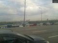
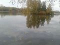
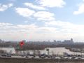
The hash is out there. 600m @55.8299,37.3944
120m to the hash @55.8327,37.3951
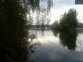
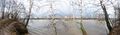
14m - the hash is in the water @55.8259,37.4020
12m to the hash - Geohashdroid turns green. @55.8258,37.4020
12m to the hash - Geohashdroid turns green. @55.8258,37.4020
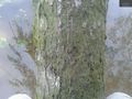
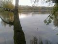
12m - climbed the tree to get closer@55.8258,37.4020
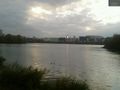
120m from the hash. @55.8260,37.4002
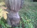
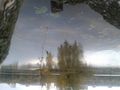
160m from the hash, work of beavers. @55.8260,37.4002


Retro 2013-04-24
vb: I was attending an event held at the conference center seen in one of the photos above, and used the occasion to return to the hash. Made some photos and additional GPS measurements. This time geohashdroid congratulated me several times with reaching the location (to GPS precision of the device) even on the bank of the river. I'll add more about it later.
The weather was cloudy but worm at first. Then ice-cold rain, with some ice indeed, happened. After I finished with the hash, it became worm and sunny again.
Retro photos
close to the hash

a fieldfare (probably) - not far away from the hash (also video)
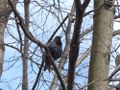
a starling (probably) - not far away from the hash


