Difference between revisions of "2012-10-13 42 -89"
imported>Swensonj (→Expedition: success!) |
m (Replacing tracklog = File:2012-10-13 42 -89 Tron.png with tracklog = {{canonicalurl:File:2012-10-13 42 -89 Tron.png}}) |
||
| (10 intermediate revisions by 4 users not shown) | |||
| Line 10: | Line 10: | ||
== Participants == | == Participants == | ||
| − | [[User:swensonj|SwensonJ]] | + | [[User:swensonj|SwensonJ]] and son |
== Plans == | == Plans == | ||
| Line 16: | Line 16: | ||
== Expedition == | == Expedition == | ||
| − | + | This was a straightforward trip. To make things more interesting, my son and I were aiming for the [[Tron achievement]]. | |
| + | |||
| + | The trip took about 40 minutes from Platteville: we arrived at 3:45 p.m. The hash is maybe 100m from the road. A quick walk across alfalfa, and a short GPS dance, were all we needed. We stayed until 4 p.m., but as we weren't expecting anyone else, bailed out right afterward. | ||
| + | |||
| + | The trip home was much longer in miles, but not many more minutes, because we spent a lot of it on the divided highway. We stopped at the toy store in Mineral Point, though, so we didn't get home until about 5:15. We attentively got off the highway one exit early and circled around our house to approach it from the north and finish off the [[Tron achievement|Tron]] in style. | ||
| + | |||
| + | ===edit=== | ||
| + | |||
| + | Only later did we realize that, by completing a geohash in Lafayette County, Wisconsin, we had satisfied [[User:Dvdwinter9|David's]] [[A Tale of Two Hashes achievement|Tale of Two Hashes]] [[2012-03-03_40_-86|challenge]]! [[User:Swensonj|Swensonj]] 23:18, 24 November 2012 (EST) | ||
== Photos == | == Photos == | ||
| Line 23: | Line 31: | ||
--> | --> | ||
<gallery perrow="5"> | <gallery perrow="5"> | ||
| + | Image:2012-10-13 42 -89 RoadSign.jpg | "Roller Coaster Road" was well named! | ||
| + | Image:2012-10-13 42 -89 Proof.jpg | We made it! | ||
| + | Image:2012-10-13 42 -89 Grin.jpg | SwensonJ at hash | ||
| + | Image:2012-10-13 42 -89 Kid.jpg | SwensonJ's son at hash | ||
| + | Image:2012-10-13 42 -89 Time.jpg | We were there for the 4 p.m. Saturday meetup... | ||
| + | Image:2012-10-13 42 -89 Tron.png | ...and went home through Mineral Point, WI, to finish the [[Tron achievement]] | ||
</gallery> | </gallery> | ||
| + | |||
== Achievements == | == Achievements == | ||
{{#vardefine:ribbonwidth|800px}} | {{#vardefine:ribbonwidth|800px}} | ||
| − | + | {{land geohash | |
| + | |||
| + | | latitude = 42 | ||
| + | | longitude = -89 | ||
| + | | date = 2012-10-13 | ||
| + | | name = SwensonJ | ||
| + | | image = 2012-10-13_42_-89_Proof.jpg | ||
| + | |||
| + | }} | ||
| + | {{consecutive geohash | ||
| + | |||
| + | | count = 2 | ||
| + | | latitude = 43 | ||
| + | | longitude = -89 | ||
| + | | date = 2012-10-12 | ||
| + | | name = SwensonJ | ||
| + | |||
| + | }} | ||
| + | {{Minesweeper geohash | ||
| + | | graticule = Dubuque, Iowa | ||
| + | | ranknumber = 4 | ||
| + | | n = true | ||
| + | | ne = true | ||
| + | | e = true | ||
| + | | w = true | ||
| + | | name = SwensonJ | ||
| − | + | }} | |
| − | + | {{Tron | |
| − | + | | latitude = 42 | |
| − | + | | longitude = -89 | |
| − | + | | date = 2012-10-13 | |
| − | + | | tracklog = {{canonicalurl:File:2012-10-13 42 -89 Tron.png}} | |
| − | + | | possessive = his | |
| − | + | | name = SwensonJ | |
| − | + | | image = 2012-10-13_42_-89_Tron.png | |
| − | |||
| − | |||
| − | |||
| + | }} | ||
| + | {{A Tale of Two Hashes | ||
| − | -- | + | | latitude = 42 |
| − | + | | longitude = -89 | |
| − | + | | date = 2012-10-13 | |
| − | + | | user2 = Dvdwinter9 | |
| − | + | | place = Lafayette | |
| − | + | | name = SwensonJ | |
| − | + | | image = 2012-10-13_42_-89_Grin.jpg | |
| − | |||
| − | + | }} | |
| − | |||
| − | |||
| − | |||
| − | |||
| − | + | [[Category:Expeditions]] | |
| + | [[Category:Expeditions with photos]] | ||
| + | [[Category:Coordinates reached]] | ||
| + | {{location|US|WI|LF}} | ||
Latest revision as of 11:47, 19 February 2020
| Sat 13 Oct 2012 in 42,-89: 42.6545215, -89.9964695 geohashing.info google osm bing/os kml crox |
Location
Farmland east of Darlington, Wisconsin, off County Highway M
Participants
SwensonJ and son
Plans
This is about as close to my home (Platteville, WI) as a hash can be in the Rockford, Illinois graticule. I'm trying for the XKCD meetup: Saturday at 4 p.m.
Expedition
This was a straightforward trip. To make things more interesting, my son and I were aiming for the Tron achievement.
The trip took about 40 minutes from Platteville: we arrived at 3:45 p.m. The hash is maybe 100m from the road. A quick walk across alfalfa, and a short GPS dance, were all we needed. We stayed until 4 p.m., but as we weren't expecting anyone else, bailed out right afterward.
The trip home was much longer in miles, but not many more minutes, because we spent a lot of it on the divided highway. We stopped at the toy store in Mineral Point, though, so we didn't get home until about 5:15. We attentively got off the highway one exit early and circled around our house to approach it from the north and finish off the Tron in style.
edit
Only later did we realize that, by completing a geohash in Lafayette County, Wisconsin, we had satisfied David's Tale of Two Hashes challenge! Swensonj 23:18, 24 November 2012 (EST)
Photos
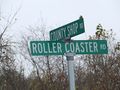
"Roller Coaster Road" was well named!
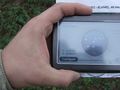
We made it!
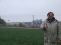
SwensonJ at hash
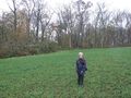
SwensonJ's son at hash
We were there for the 4 p.m. Saturday meetup...
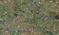
...and went home through Mineral Point, WI, to finish the Tron achievement


Achievements
SwensonJ earned the Land geohash achievement
|
SwensonJ earned the Consecutive geohash achievement
|
SwensonJ achieved level 4 of the Minesweeper Geohash achievement
|
SwensonJ earned the Tron achievement
|
