Difference between revisions of "2012-10-17 33 -117"
From Geohashing
imported>LucasBrown (→Expedition) |
|||
| (7 intermediate revisions by 3 users not shown) | |||
| Line 1: | Line 1: | ||
| − | |||
| − | |||
| − | |||
| − | |||
| − | |||
| − | |||
| − | |||
| − | |||
| − | |||
| − | |||
{{meetup graticule | {{meetup graticule | ||
| lat=33 | | lat=33 | ||
| Line 15: | Line 5: | ||
}} | }} | ||
| − | |||
__NOTOC__ | __NOTOC__ | ||
== Location == | == Location == | ||
| − | + | * Looks like a good one for San Diego GeoHashers since ours is once again floating in Mexican waters. ({{egl|2012-10-17|32|-117}}). It is on Camino Del Norte in 4S Ranch. Maybe a good one for a Speed Racer Achievement -- [[User:Mathgeek|Mathgeek]] 11:19, 17 October 2012 (PDT) | |
| − | |||
| − | * Looks like a good one for San Diego GeoHashers since ours is once again floating in Mexican waters. ( | ||
== Participants == | == Participants == | ||
| − | |||
| − | |||
* - [[User:Mathgeek|Mathgeek]] | * - [[User:Mathgeek|Mathgeek]] | ||
| + | * - [[User:LucasBrown|LucasBrown]] | ||
== Plans == | == Plans == | ||
| − | |||
| − | |||
* - I might be able to drive over there after dropping the GeoDude off at baseball practice... after 5:00 pm. -- [[User:Mathgeek|Mathgeek]] | * - I might be able to drive over there after dropping the GeoDude off at baseball practice... after 5:00 pm. -- [[User:Mathgeek|Mathgeek]] | ||
== Expedition == | == Expedition == | ||
| − | |||
| − | |||
| − | |||
*Arrived... Dodged a few cars... Grabbed a geocache... Now I'm going to head back to the car and earn the Speed Racer achievement. :) -- [[User:Mathgeek|Mathgeek]] [http://www.openstreetmap.org/?lat=33.01688765&lon=-117.11236328&zoom=16&layers=B000FTF @33.0169,-117.1124] 17:43, 17 October 2012 (PDT) | *Arrived... Dodged a few cars... Grabbed a geocache... Now I'm going to head back to the car and earn the Speed Racer achievement. :) -- [[User:Mathgeek|Mathgeek]] [http://www.openstreetmap.org/?lat=33.01688765&lon=-117.11236328&zoom=16&layers=B000FTF @33.0169,-117.1124] 17:43, 17 October 2012 (PDT) | ||
| − | + | [[User:LucasBrown|LucasBrown]] reached the hashpoint at about 21:15 PDT. | |
| − | |||
| − | |||
| − | |||
== Photos == | == Photos == | ||
| − | |||
| − | |||
| − | |||
<gallery perrow="5"> | <gallery perrow="5"> | ||
| − | |||
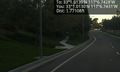
Image:2012-10-17_33_-117_17-32-18-998.jpg | Here I am... Dodging traffic. [http://www.openstreetmap.org/?lat=33.01688906&lon=-117.11238741&zoom=16&layers=B000FTF @33.0169,-117.1124] | Image:2012-10-17_33_-117_17-32-18-998.jpg | Here I am... Dodging traffic. [http://www.openstreetmap.org/?lat=33.01688906&lon=-117.11238741&zoom=16&layers=B000FTF @33.0169,-117.1124] | ||
| − | |||
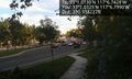
Image:2012-10-17_33_-117_17-36-32-744.jpg | View of the nearby geocache. (GC1NF28) [http://www.openstreetmap.org/?lat=33.01688411&lon=-117.11238493&zoom=16&layers=B000FTF @33.0169,-117.1124] | Image:2012-10-17_33_-117_17-36-32-744.jpg | View of the nearby geocache. (GC1NF28) [http://www.openstreetmap.org/?lat=33.01688411&lon=-117.11238493&zoom=16&layers=B000FTF @33.0169,-117.1124] | ||
| − | |||
Image:2012-10-17_33_-117_17-39-09-263.jpg | View of the hash site from the cache location (GC1NF28). [http://www.openstreetmap.org/?lat=33.01720773&lon=-117.11331756&zoom=16&layers=B000FTF @33.0172,-117.1133] | Image:2012-10-17_33_-117_17-39-09-263.jpg | View of the hash site from the cache location (GC1NF28). [http://www.openstreetmap.org/?lat=33.01720773&lon=-117.11331756&zoom=16&layers=B000FTF @33.0172,-117.1133] | ||
| − | |||
Image:2012-10-17_33_-117_17-56-00-712.jpg | The geohybrid and I around the corner after blazing through the hash site. [http://www.openstreetmap.org/?lat=33.01624100&lon=-117.11171555&zoom=16&layers=B000FTF @33.0162,-117.1117] | Image:2012-10-17_33_-117_17-56-00-712.jpg | The geohybrid and I around the corner after blazing through the hash site. [http://www.openstreetmap.org/?lat=33.01624100&lon=-117.11171555&zoom=16&layers=B000FTF @33.0162,-117.1117] | ||
| − | |||
Image:2012-10-17_33_-117_21-22-04-613.jpg | ([[User:LucasBrown|LucasBrown]]) Map at the hashpoint | Image:2012-10-17_33_-117_21-22-04-613.jpg | ([[User:LucasBrown|LucasBrown]]) Map at the hashpoint | ||
| − | |||
Image:2012-10-17_33_-117_21-22-36-050.jpg | ([[User:LucasBrown|LucasBrown]]) Geohash Droid details page at the hashpoint | Image:2012-10-17_33_-117_21-22-36-050.jpg | ([[User:LucasBrown|LucasBrown]]) Geohash Droid details page at the hashpoint | ||
</gallery> | </gallery> | ||
| Line 64: | Line 33: | ||
== Achievements == | == Achievements == | ||
{{#vardefine:ribbonwidth|800px}} | {{#vardefine:ribbonwidth|800px}} | ||
| − | |||
{{Speed racer | latitude = 33 | longitude = -117 | date = 2012-10-17 | name = Mathgeek | image = 2012-10-17 33 -117 17-56-00-712.jpg }} | {{Speed racer | latitude = 33 | longitude = -117 | date = 2012-10-17 | name = Mathgeek | image = 2012-10-17 33 -117 17-56-00-712.jpg }} | ||
{{Hash collision | latitude = 33 | longitude = -117 | date = 2012-10-17 | name = Mathgeek | link = http://www.geocaching.com/seek/cache_details.aspx?wp=GC1NF28 | id = GC1NF28 | distance = 300 ft }} | {{Hash collision | latitude = 33 | longitude = -117 | date = 2012-10-17 | name = Mathgeek | link = http://www.geocaching.com/seek/cache_details.aspx?wp=GC1NF28 | id = GC1NF28 | distance = 300 ft }} | ||
| − | |||
| − | |||
| − | |||
| − | + | {{Speed racer | latitude = 33 | longitude = -117 | date = 2012-10-17 | name = LucasBrown}} | |
| − | + | {{Consecutive geohash | count = 2 | latitude = 33 | longitude = -117 | date = 2012-10-17 | name = LucasBrown}} | |
| − | |||
| − | -- | ||
| − | |||
[[Category:Expeditions]] | [[Category:Expeditions]] | ||
| − | |||
[[Category:Expeditions with photos]] | [[Category:Expeditions with photos]] | ||
| − | |||
[[Category:Expedition without GPS]] | [[Category:Expedition without GPS]] | ||
| − | |||
| − | |||
| − | |||
[[Category:Coordinates reached]] | [[Category:Coordinates reached]] | ||
| − | + | {{location|US|CA|SD}} | |
| − | |||
| − | |||
| − | |||
| − | |||
| − | |||
| − | |||
| − | |||
| − | |||
| − | |||
| − | |||
| − | |||
| − | |||
| − | |||
| − | |||
| − | |||
| − | |||
| − | |||
Latest revision as of 16:55, 26 March 2020
| Wed 17 Oct 2012 in 33,-117: 33.0168831, -117.1123793 geohashing.info google osm bing/os kml crox |
Location
- Looks like a good one for San Diego GeoHashers since ours is once again floating in Mexican waters. (2012-10-17 32 -117). It is on Camino Del Norte in 4S Ranch. Maybe a good one for a Speed Racer Achievement -- Mathgeek 11:19, 17 October 2012 (PDT)
Participants
- - Mathgeek
- - LucasBrown
Plans
- - I might be able to drive over there after dropping the GeoDude off at baseball practice... after 5:00 pm. -- Mathgeek
Expedition
- Arrived... Dodged a few cars... Grabbed a geocache... Now I'm going to head back to the car and earn the Speed Racer achievement. :) -- Mathgeek @33.0169,-117.1124 17:43, 17 October 2012 (PDT)
LucasBrown reached the hashpoint at about 21:15 PDT.
Photos

Here I am... Dodging traffic. @33.0169,-117.1124
View of the nearby geocache. (GC1NF28) @33.0169,-117.1124
View of the hash site from the cache location (GC1NF28). @33.0172,-117.1133

The geohybrid and I around the corner after blazing through the hash site. @33.0162,-117.1117
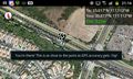
(LucasBrown) Map at the hashpoint
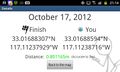
(LucasBrown) Geohash Droid details page at the hashpoint


Achievements

Mathgeek earned the Speed racer achievement
by passing through the (33, -117) geohash on 2012-10-17 at the maximum legal speed.

Mathgeek earned the Hash collision achievement
|
LucasBrown earned the Speed racer achievement
by passing through the (33, -117) geohash on 2012-10-17 at the maximum legal speed.
LucasBrown earned the Consecutive geohash achievement
|