Difference between revisions of "2012-10-21 33 -116"
From Geohashing
imported>LucasBrown |
imported>LucasBrown (→Photos) |
||
| Line 14: | Line 14: | ||
== Photos == | == Photos == | ||
<gallery perrow="5"> | <gallery perrow="5"> | ||
| − | Image:2012-10-21_33_-116_17-19-08-430.jpg | Geotrash: a mylar baloon was found | + | Image:2012-10-21_33_-116_17-19-08-430.jpg | Geotrash: a mylar baloon was found 1.2km west of the hashpoint |
Image:2012-10-21_33_-116_17-20-01-403.jpg | View down the California Riding and Hiking Trail | Image:2012-10-21_33_-116_17-20-01-403.jpg | View down the California Riding and Hiking Trail | ||
Image:2012-10-21_33_-116_17-21-18-268.jpg | 971 meters from the hashpoint... close enough. | Image:2012-10-21_33_-116_17-21-18-268.jpg | 971 meters from the hashpoint... close enough. | ||
Revision as of 00:31, 22 October 2012
| Sun 21 Oct 2012 in 33,-116: 33.0883282, -116.4197975 geohashing.info google osm bing/os kml crox |
Location
Near the California Riding and Hiking Trail in the Anza-Borrego Desert State Park
Participants
Photos

Geotrash: a mylar baloon was found 1.2km west of the hashpoint
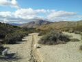
View down the California Riding and Hiking Trail
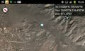
971 meters from the hashpoint... close enough.


Achievements
LucasBrown earned the GeoTrash Geohash Achievement
|