Difference between revisions of "2012-10-29 47 -122"
imported>OtherJack (planninging) |
imported>FippeBot m (Location) |
||
| (6 intermediate revisions by 2 users not shown) | |||
| Line 13: | Line 13: | ||
== Participants == | == Participants == | ||
* [[User:Thomcat|Thomcat]] | * [[User:Thomcat|Thomcat]] | ||
| − | |||
| − | |||
| − | |||
| − | |||
== Expedition == | == Expedition == | ||
| − | + | Everything running behind schedule, including my planned 5:30, er 6:00, er 7:00. Anyhow, just down the road to Seattle and a road which runs up and over the freeway. One of several, this is one of the the busiest, so traveling in early evening is probably for the best. | |
| − | == | + | Wasn't sure how I was going to shoot a speed racer at night using Geohash Droid, so it was also probably for the best that I hit a red light. As I pulled up, the GPS drifted to just over a meter away, green and with message - quickly I shot pictures with my Canon. Now for the "upload to wiki" feature. |
| − | + | ||
| + | Up the street and around for another pass (electric power only) and I punched in my message for the next time. Alas, the GPS now thought I was driving through the parking lot, or at least on the sidewalk. Since I couldn't back up (much), I had to go for "send" at some distance away (although on the same spot as before!). | ||
| + | |||
| + | *On the spot! -- [[User:Thomcat|Thomcat]] [http://www.openstreetmap.org/?lat=47.61700837&lon=-122.33285283&zoom=16&layers=B000FTF @47.6170,-122.3329] 19:19, 29 October 2012 (PDT) | ||
| + | |||
| + | Up the hill for a quick visit to Half Price Books, then back through with one more pass. Is it too dark to shoot a picture of me mug and upload it? It turns out yes, definitely (see third picture below). This time the GPS was absolutely sure I was traveling through the parking lot. I might have done better outside the car, but I definitely crossed the spot multiple times. | ||
== Photos == | == Photos == | ||
| − | |||
| − | |||
| − | |||
<gallery perrow="5"> | <gallery perrow="5"> | ||
| + | Image:2012-10-29 47 -122 Hashpoint.jpg | Geohashdroid in the green | ||
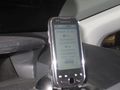
| + | Image:2012-10-29 47 -122 Hashpoint2.jpg | Alternate view | ||
| + | Image:2012-10-29_47_-122_19-45-47-386.jpg | [http://www.openstreetmap.org/?lat=47.61712769&lon=-122.33308680&zoom=16&layers=B000FTF @47.6171,-122.3331] | ||
</gallery> | </gallery> | ||
| − | |||
| − | |||
| − | |||
| − | |||
| − | |||
| − | |||
| − | |||
| − | |||
[[Category:Expeditions]] | [[Category:Expeditions]] | ||
| − | |||
[[Category:Expeditions with photos]] | [[Category:Expeditions with photos]] | ||
| − | |||
| − | |||
| − | |||
| − | |||
| − | |||
[[Category:Coordinates reached]] | [[Category:Coordinates reached]] | ||
| − | + | {{location|US|WA|KN}} | |
| − | |||
| − | |||
| − | |||
| − | |||
| − | |||
| − | |||
| − | |||
| − | |||
| − | |||
| − | |||
| − | |||
| − | |||
| − | |||
| − | |||
| − | |||
| − | |||
| − | |||
Latest revision as of 06:42, 13 August 2019
| Mon 29 Oct 2012 in Seattle: 47.6170564, -122.3328913 geohashing.info google osm bing/os kml crox |
Location
The middle of Boren Ave near Stewart on Seattle's Capitol Hill.
Participants
Expedition
Everything running behind schedule, including my planned 5:30, er 6:00, er 7:00. Anyhow, just down the road to Seattle and a road which runs up and over the freeway. One of several, this is one of the the busiest, so traveling in early evening is probably for the best.
Wasn't sure how I was going to shoot a speed racer at night using Geohash Droid, so it was also probably for the best that I hit a red light. As I pulled up, the GPS drifted to just over a meter away, green and with message - quickly I shot pictures with my Canon. Now for the "upload to wiki" feature.
Up the street and around for another pass (electric power only) and I punched in my message for the next time. Alas, the GPS now thought I was driving through the parking lot, or at least on the sidewalk. Since I couldn't back up (much), I had to go for "send" at some distance away (although on the same spot as before!).
- On the spot! -- Thomcat @47.6170,-122.3329 19:19, 29 October 2012 (PDT)
Up the hill for a quick visit to Half Price Books, then back through with one more pass. Is it too dark to shoot a picture of me mug and upload it? It turns out yes, definitely (see third picture below). This time the GPS was absolutely sure I was traveling through the parking lot. I might have done better outside the car, but I definitely crossed the spot multiple times.
Photos
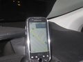
Geohashdroid in the green
Alternate view


