Difference between revisions of "2012-10-30 48 8"
imported>RecentlyChanged (→Participants) |
imported>RecentlyChanged (→Achievements) |
||
| Line 63: | Line 63: | ||
| name = RecentlyChanged | | name = RecentlyChanged | ||
| + | }} | ||
| + | {{Two to the N achievement | ||
| + | | count = 0 | ||
| + | | date = 2012-10-30 | ||
| + | | latitude = 48 | ||
| + | | longitude = 8 | ||
| + | | name = RCs older sis | ||
}} | }} | ||
Revision as of 17:52, 23 February 2016
| Tue 30 Oct 2012 in 48,8: 48.2965765, 8.0338569 geohashing.info google osm bing/os kml crox |
Location
Somewhere near the street on my way back home.
Participants
- RecentlyChanged and his sister
Plans
I decided spontaneous to visit the Hashpoint on my way from Karlsruhe back home.
Expedition
I found the right street without my (new) GPS-device and a place to park my car. Then I took my device out of the back of my car, but I hadn't saved the Geohash as waypoint, only the coordinates which I deleted by mistake. I thought I find the place without because I've seen it on GMaps, but ... yes you can see it on the Tracklog. I was wrong.
So this was my first failed Geohash Expedition.
Tracklog
http://www.everytrail.com/view_trip.php?trip_id=1864506&code=27d5ae3f59e0590a5f1eaf9106ce6b80
Photos
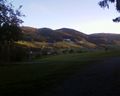
A view from the Hilltop near by...
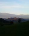
and another one on my way back down
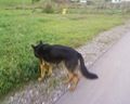
And a funny dog which always jumped on us, and lost interest at the moment I want to take the Photo

Of course I dont forget my Stupid Grin...

and I told my sister to do so too


Achievements
RecentlyChanged earned the Blinded by Science Consolation Prize
|
RecentlyChanged earned the Drag-along achievement
|
